

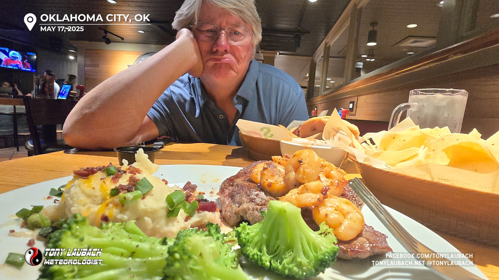
After three successful tornado chases in the prior four days, I had picked up Ed from the OKC airport after he flew in from Denver to finally join me during this legendary week. He was a couple hours behind the Pauls Valley tornado earlier that afternoon, so he had to endure a dinner date watching me enjoy a victory steak for the tornadoes I saw (alone) the last few days. But our turn was coming…
Sunday morning we awakened from our slumber at our hotel near the airport, gassed up at Casey’s nearby, and proceeded north up I-35 to Kansas. Our initial target was Great Bend, Kansas, and our route was quick, but was rather cool and cloudy. We were northbound by 10am and rolled into Great Bend shortly before 2:30pm, and the conditions hadn’t changed. Still cool, still cloudy. We grabbed gas and lunch; stopping at the local Wendy’s where short staffing held our lunch stop up nearly 20 minutes. Plenty of time to look over current data, and realizing this Great Bend target was not looking too hot.
Upon discussion while waiting for our “fast food”, we decided NOT to repeat history and sit and wait for something to happen here. Meanwhile, reports from Colorado near the KS state line of tornadoes meant that conditions out west were supportive and visible satellite showed clearing about 90 miles to our west. So with lunch FINALLY acquired, we quickly decided we were going to dive southwest on US-56 and aim for the Dodge City area where some agitated cumulus were developing. Moments after making that turn, I flipped us north on a dirt road to connect back with K-96 west of Great Bend and said I was going to “drive west til we see the sun”, and so we did.
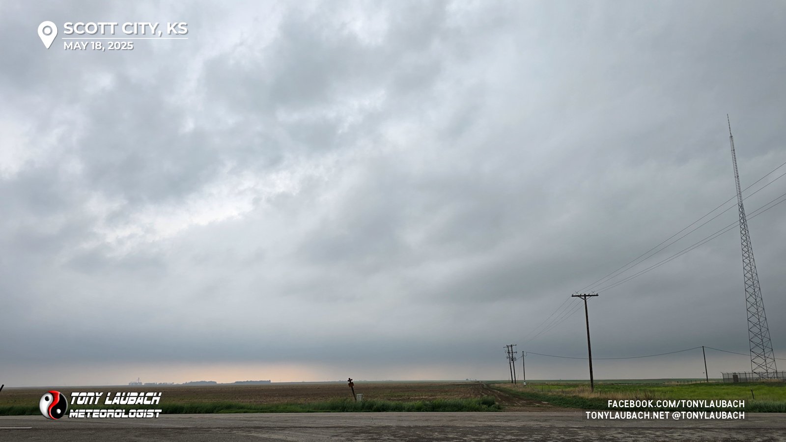
West we went through Rush Center, Ness City, and as we approached Dighton, SUN! We made it. A surface analysis showed an arcing dryline, curving from west-east to almost north-south with a few blips starting to pop. With Scott City being a bigger town, we opted to hop over there for a final fill-up. We topped off, cleaned and Rain-X’d the windows, and left ourselves with about 10 minutes before the action began to get started.
About this time, our blips were becoming full-fledged storms, with the western storm becoming tornadic. Our focus was the eastern storm as it was not going to be sucking in the air of a sibling like the western storm. We decided to roll the dice on the cell to our immediate west (the eastern cell), figuring it might choke off the western cell, and even if the western cell survived, it was coming toward our north route (US-83) anyway.
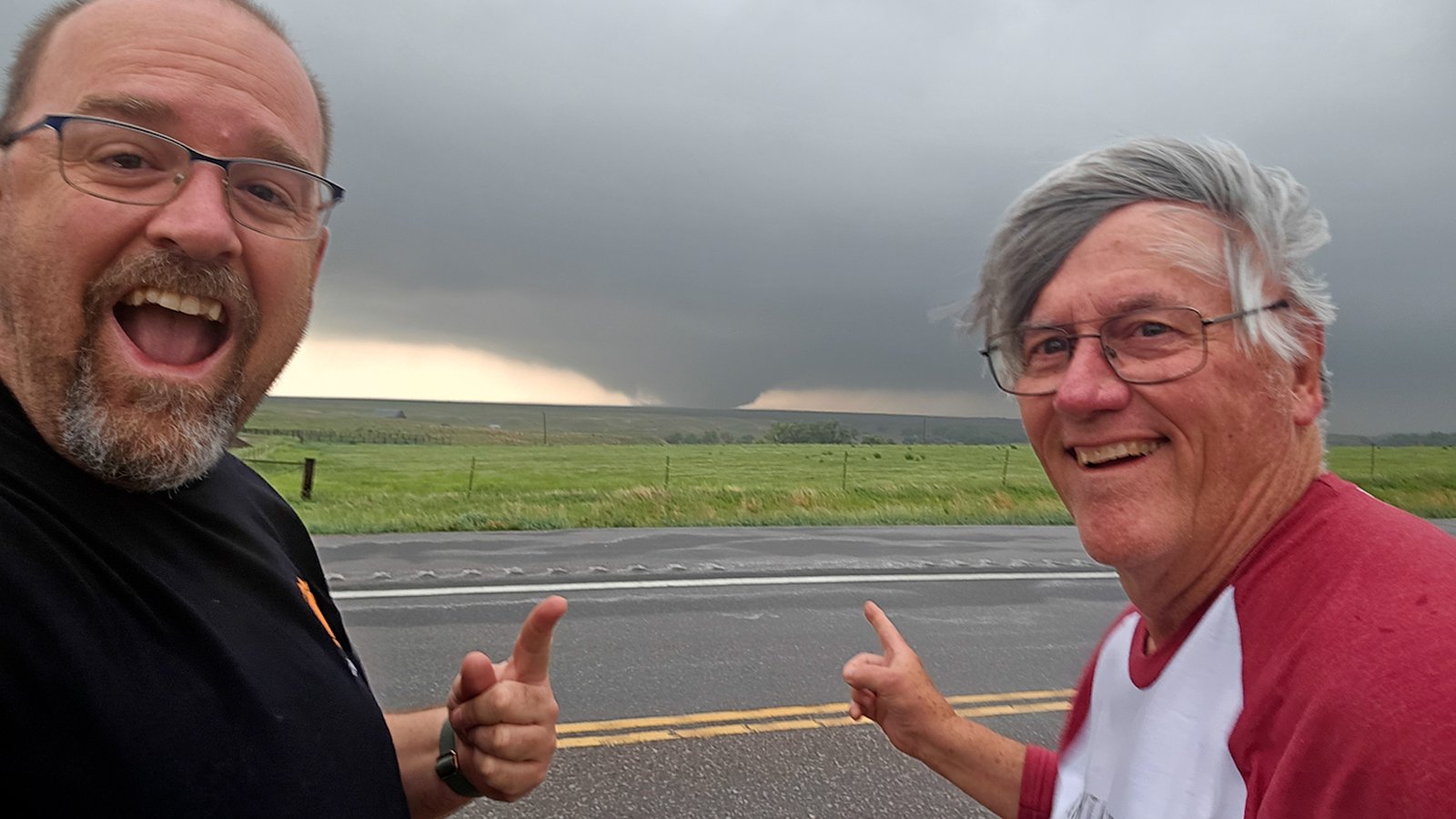
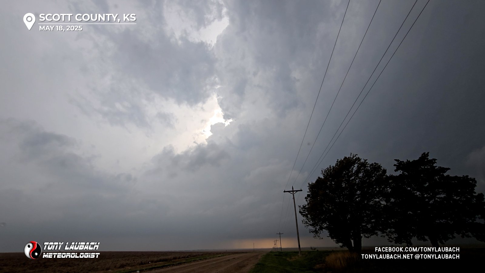
We drifted a few miles north to maintain a view of the base… inflow was massive and while the view of the updraft wasn’t great due to clouds, we would occasionally see a massive barber pole in the breaks. The storm was far enough west where we didn’t have the greatest contrast, it quickly became evident ‘something’ was happening.
We crawled up US-83, staying with this cell as it slowly drifted north/northeast west of the highway. The storm was rapidly intensifying by this point.
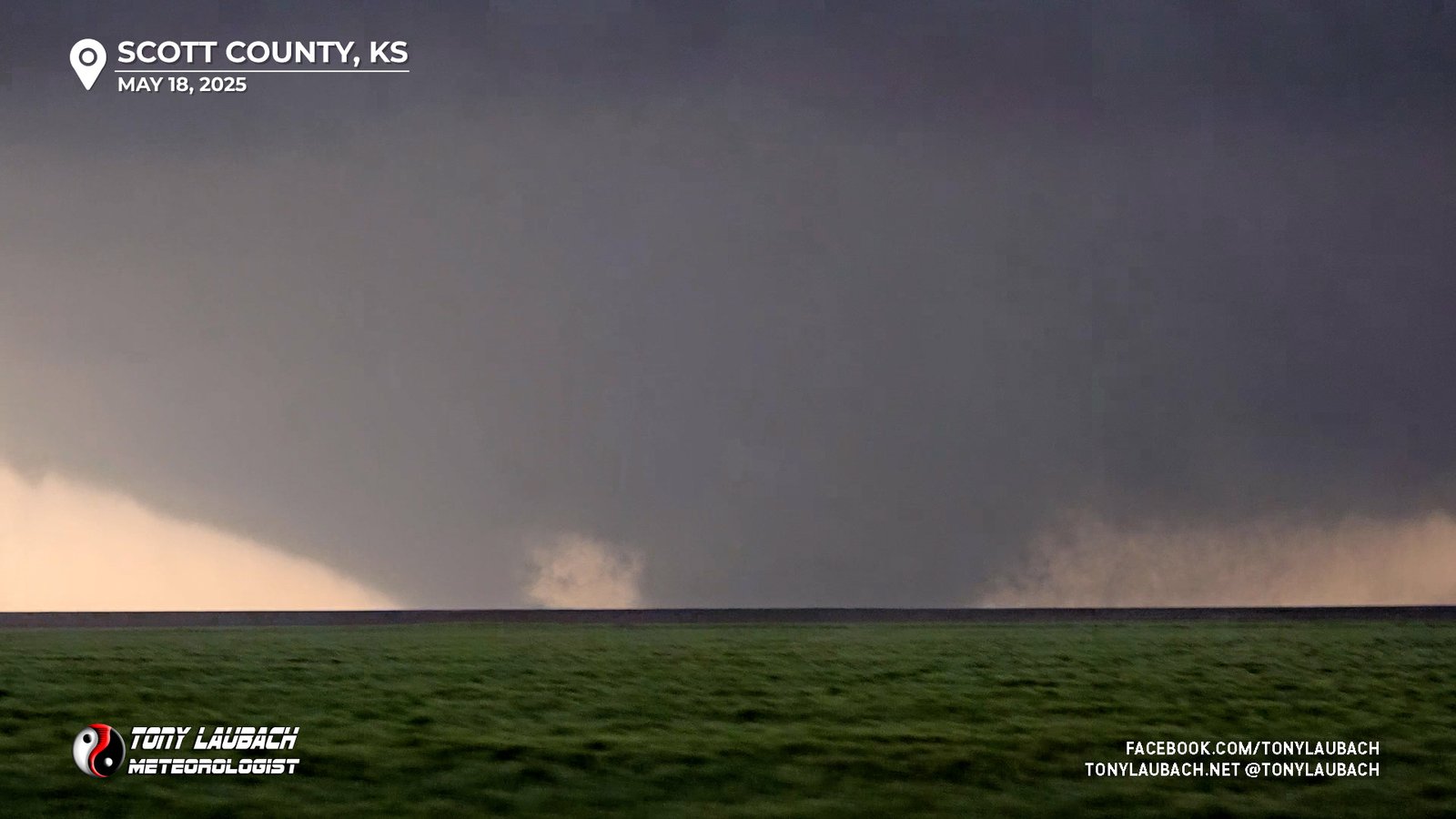
I was relaying info via NWS chat to Dodge City’s NWS office, giving them a textual play-by-play as several funnels would tease their way down, when finally, the first tornado, a briefy, dropped shortly after 5:30pm north of Scott City.
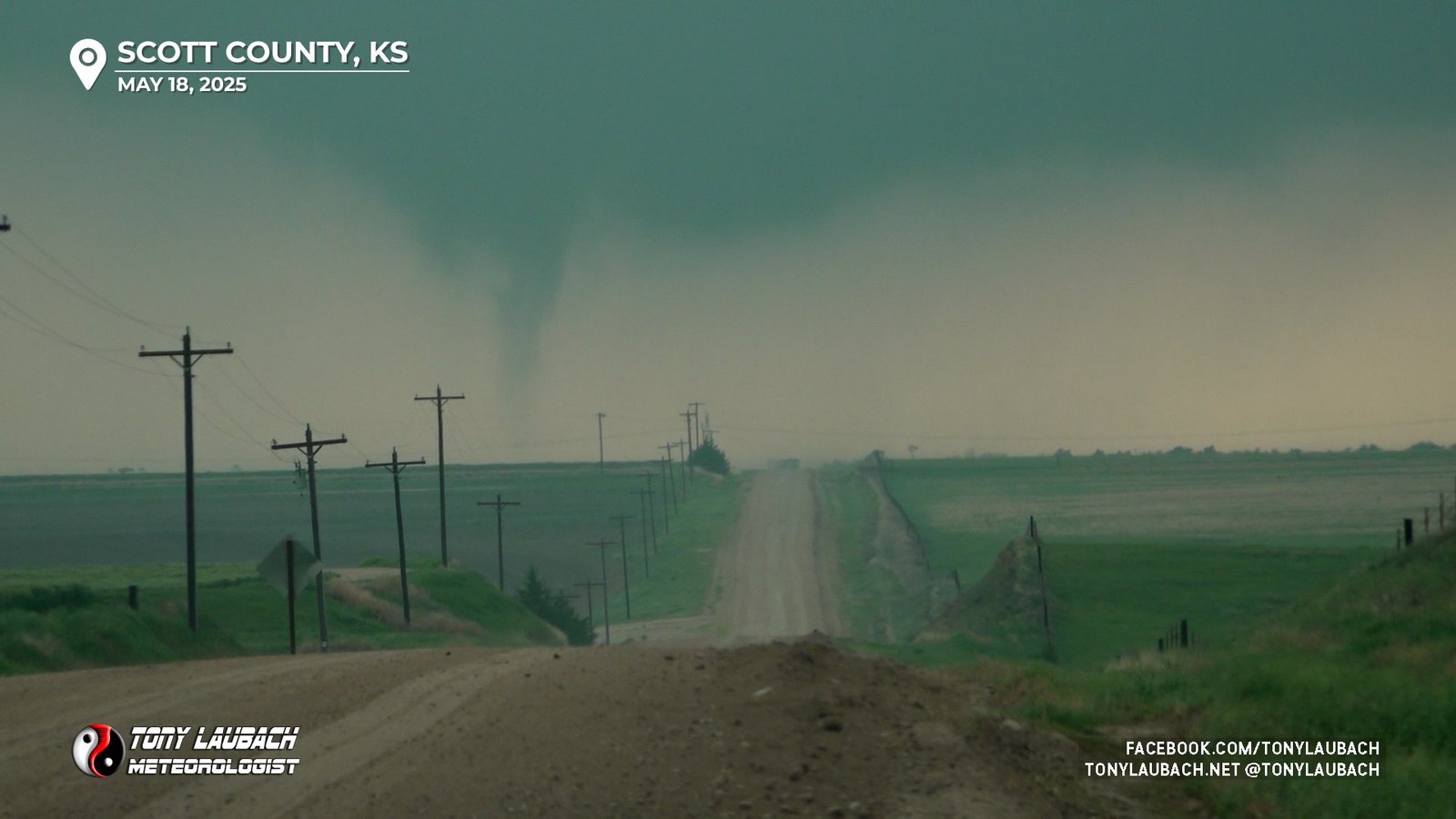
Most of the east/west dirt roads branching off US-83 were very muddy and we did not want to chance getting stuck in a greedy move to try and get further west and ultimately closer, so we decided to stick with the pavement that was the highway, sliding north with the storm as it continued to spin away to our west.
The storm, which started getting some wheels to it, began to move a bit more quickly (seemingly), more likely just cause we let it get north of us a bit, so we were on the move northbound when a new area of circulation got organized and quickly started to develop a funnel cloud.
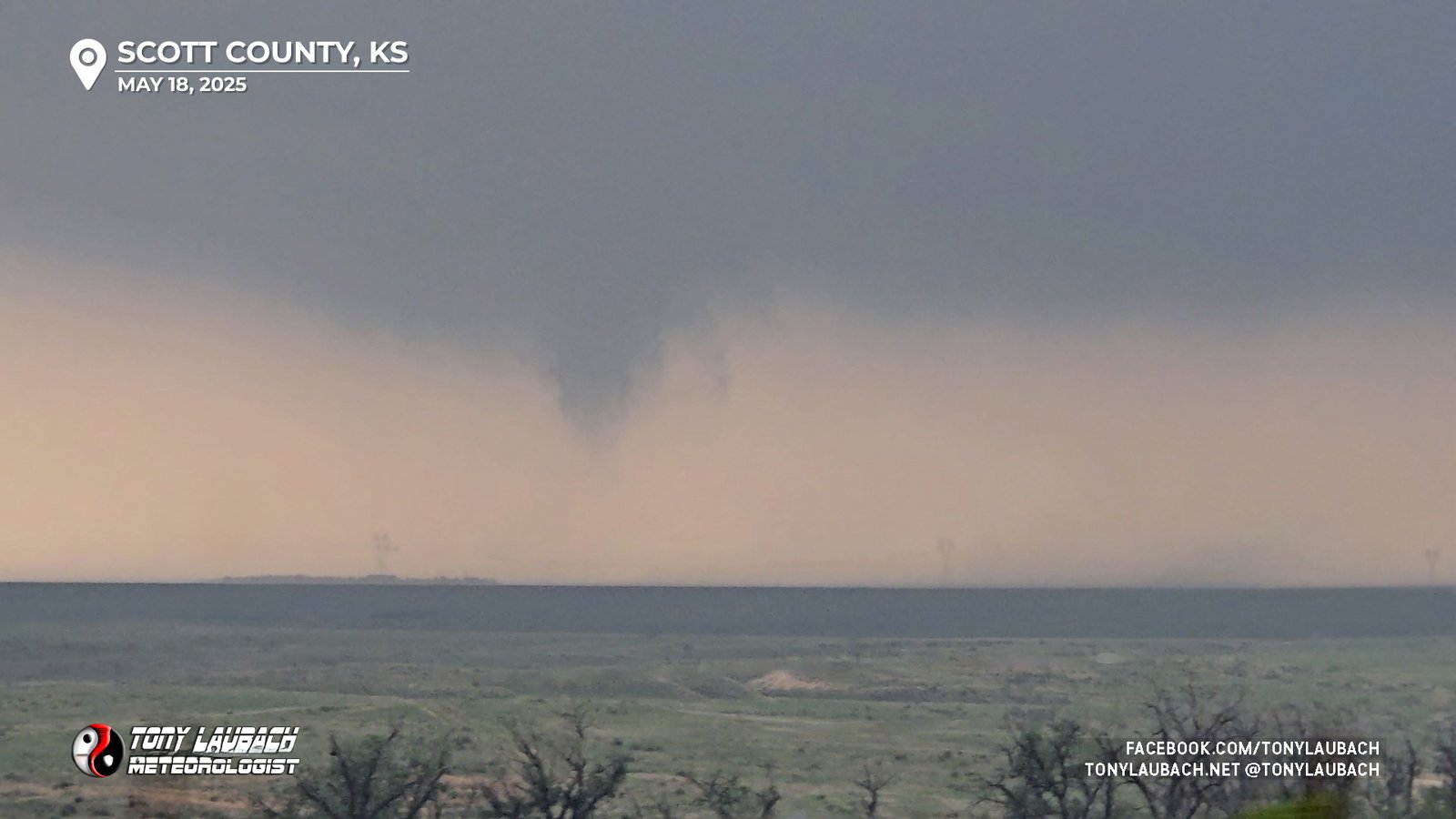
As this area as organizing, and likely making ground contact, a second area of rotation to the north of that also began to twist down a funnel, and within moments, we had two distinct tornadic circulations touching down simultaneously.
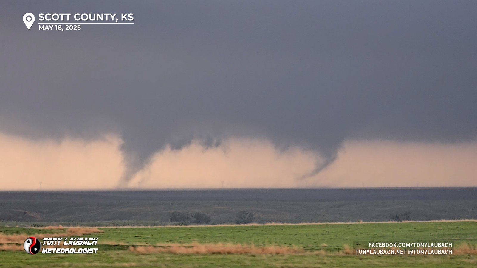
The south funnel would dissipate as the northern funnel took over, growing quickly in size as the storm blasted north.
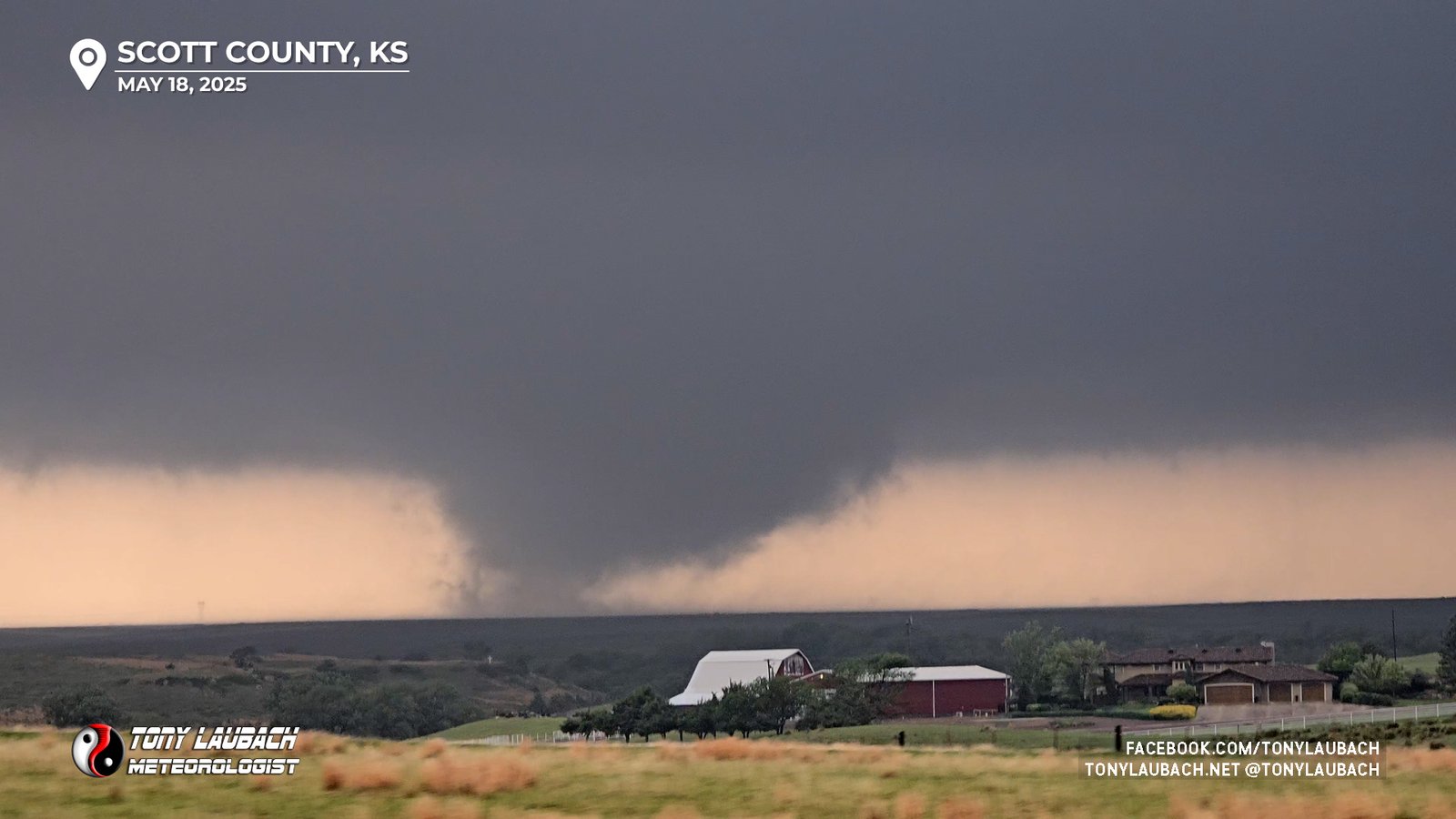
It took a few minutes before our third tornado really became established. While the funnel was growing wider, it was still somewhat disorganized at the ground and hadn’t fully condensed to the width the funnel was indicating it would be. We put a couple more miles on before we pulled off the highway to get a stationary view as the tornado finally became fully established as the long-track wedge it was to become.
And so began about a 15-minute show that we watched along US-83. We’d move a few miles north, stop again for shots, then continue north, watching as this massive wedge churned away across northern Scott County.

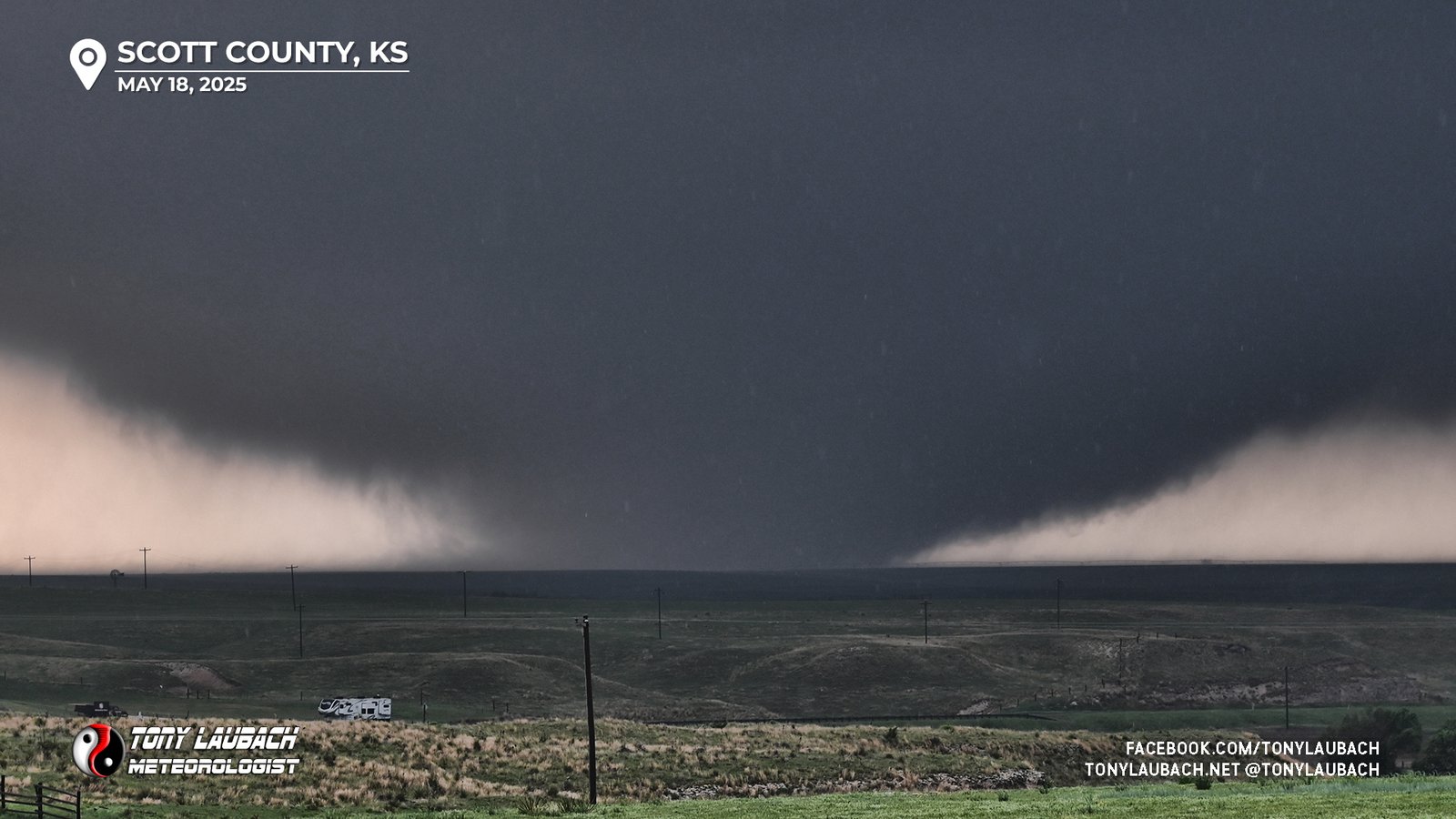
We crossed north of the county line into southeastern Gove County, still tracking this large tornado as it was slowly approaching US-83 while on its (mostly) north/northeasterly track. We found a great elevated view point at a historic marker south of Elkader where the approaching wedge was front lit by sunrays peaking ahead of the supercell as it neared the highway.
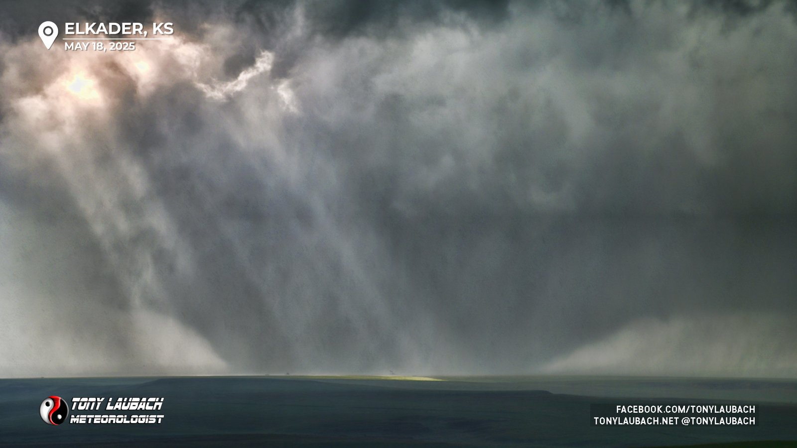
This was our longest stop to observe this tornado, and we were deciding how to proceed. The core of this storm was starting to approach our highway to our north between us and Oakley, and it had some very large hail. Of course with the storm’s core would follow the tornadic part of the storm, which would also move across the highway. And as we noted earlier, roads off the main highway were not in great shape, so once the storm crossed east of 83, we’d lose it and have no real way to keep up with it.
But…
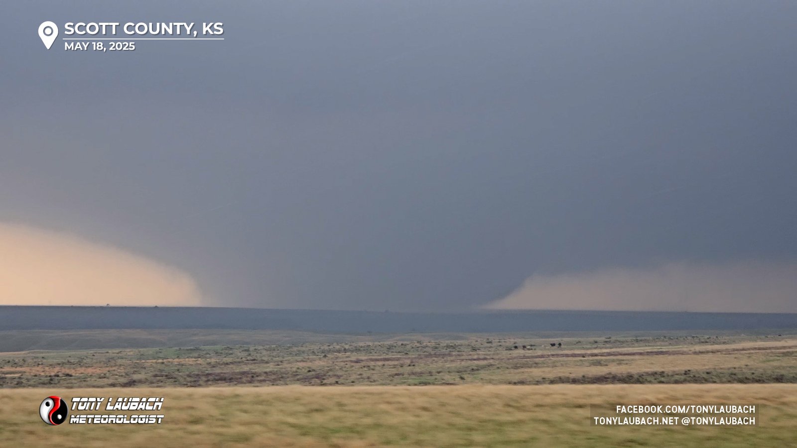
Another cell had developed south of us near Scott City and was ALSO moving north/northeast just to the east of the path from our storm, and it was tornado-warned in the time we were discussion this option. We decided to watch our wedge move out of sight, what we figured to be getting blocked by precip. Keep that in mind, it’s important to the story coming up.
So we left it, yes, we actually left a WEDGE IN PROGRESS…
So we dove back south about 10 minutes or so to near K-4 and US-83, getting in view of the business end of this new cell to our south. When we arrived in view, there was not a tornado ongoing, but that would change pretty quick, although not as dramatically as the initial show prior.

This is where I almost blew the chase, certainly THIS part of the chase. On our initial roll through here, I remembered seeing a westerly state highway which lead to Lake Scott State Park (K-95). I thought this would be an ideal route to at least keep us closer as the northeasterly dogleg on US-83 would push us about two miles further east when it eventually straightened out again.
We agreed on the this route, and when we hit the junction there near Camp Christy, we detoured onto K-95 as a fifth tornado began to organize to our west as we made the turn back to the north, but as we were getting cameras out to film the developing tornado, we dropped into what felt like a canyon in Kansas, and lost all visibility to the west. Service here went non-existent, so neither of us could get a satellite view of the road ahead. We decided to press on, me growing more and more frustrated as the canyon saw no end as we approached the lake, and there was obviously a tornado TRYING to develop that we no longer had any idea if it was there or not.
We debated about doubling back, but decided it would take about the same amount of time to get back to US-83 and circled back up as it would to just proceed; K-95 would turn back east and connect again with US-83 east of the lake, and we felt confident the path of this tornado would remain west of the highway long enough where we weren’t concerned about getting rolled by it, so I pressed the gas a bit and we got to the turn east and as we climbed out of the canyon, we watched as the tornado roped-out. Our fifth tornado that we assumed we saw the start and end of, but nothing in between.
I was annoyed to say the least… but the chase went on. From the north junction of K-95 and US-83, we got service back and took a moment to gather up some new radar data. Our original tornadic storm was STILL very much tornadic south of I-70 to our north. And our current storm was not currently producing a tornado and was looking much leaner compared to the monster brother to the north. We were under the impression that our original storm was STILL producing the monster tornado we watched move out of sight earlier near Elkader, and it had just BARELY crossed the highway to about halfway between us and Oakley (about 15 miles-ish to our north).
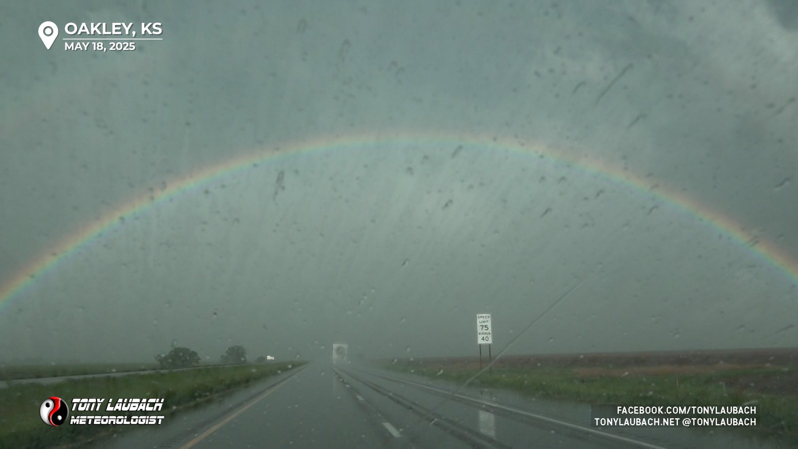
We didn’t waste a ton of time in discussion; our present storm had a meager radar appearance and was not producing a tornado. And our former storm was within range, had a monster hook/couplet on radar and was likely producing the same tornado (so we thought). Our choice was clear, lets beat it to I-70. We gunned north, rolling through some quarter-sized hail of the southern storm’s core. The thought, get to Oakley, and get east on I-70 to try and meet it.
We weren’t sure if we could get EAST of the tornado’s path, so we figured we’d be viewing this from the west. The thought was to let it cross to our east, then sneak south of it to get a view as it got north of I-70. That was the plan, and a decent one on paper, but little did we know what we were signing up for.

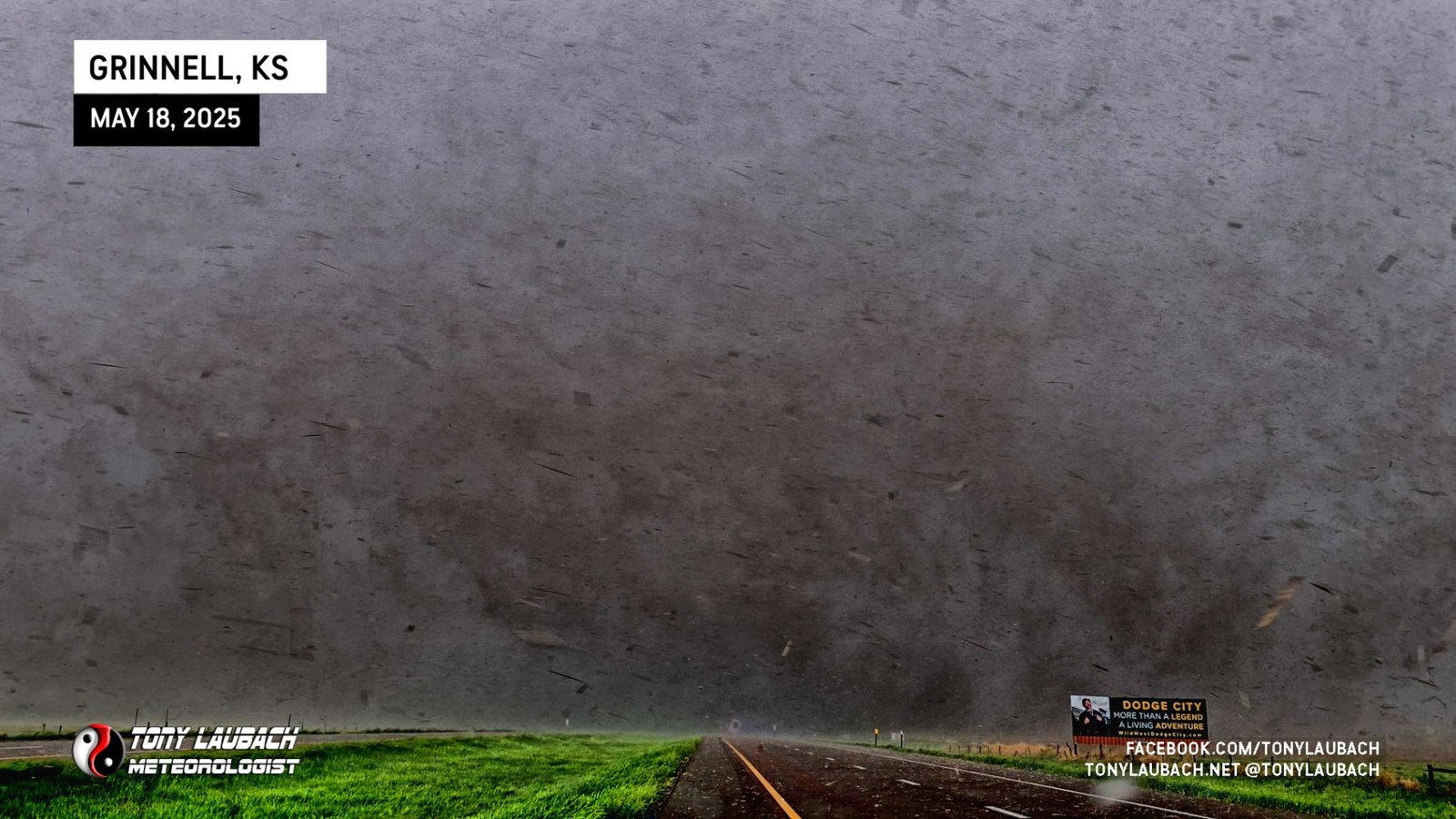
As we got onto I-70, we had about 10 miles to the Grinnell exit, and that was kinda the goal. We wanted to get the best time on the 75mph interstate getting east to see if we could beat the couplet, but it became very evident very quickly that we were NOT going to do that. Clearly, at least according to radar, there was STILL a tornado going on, and we were both marveling over how long this thing had been going and were thinking are we about to make a SECOND intercept of a same tornado after leaving the storm and seeing two others?
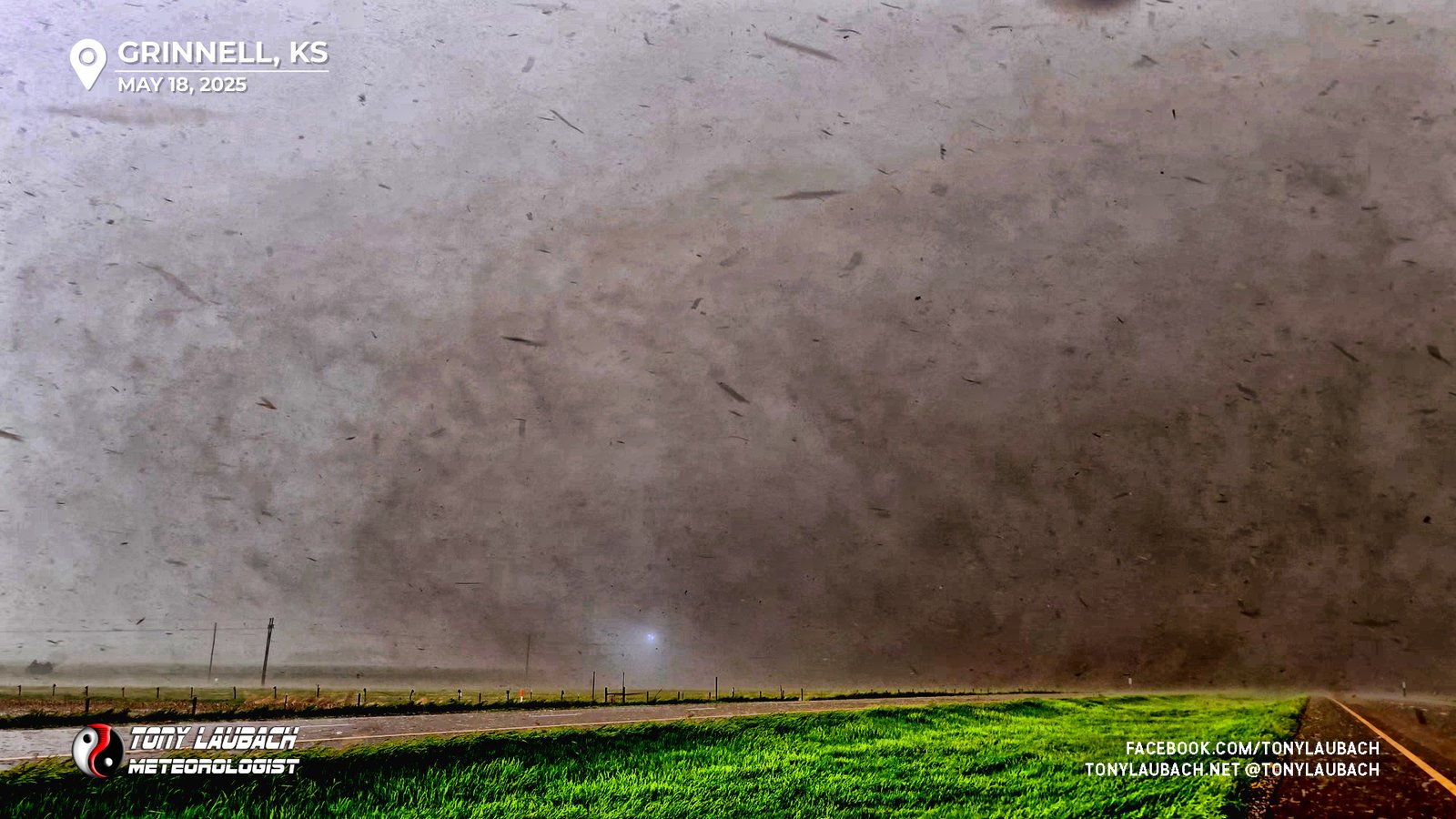
As we neared Mile Marker 84 a couple miles east of the Grinnell exit, visibility became very low, and multiple vehicles were pulled over on both sides of the interstate. We slowed to a crawl, monitoring wind and keeping our heads on a swivel. Radar indicated the circulation was just south, if not right on I-70 by this point. With visibility low, we figured we were on the back end of the RFD as winds were screaming north to south over us.
With the left shoulder clear, we went ahead and pulled off, drifting about 5-10mph to the east. Suddenly, we found ourselves getting hammered by heavy amounts of field debris (corn husks, etc). With no view of an actual tornado, we knew one was there, but I assumed, based on radar timing and wind direction, that it was on and/or just barely north of I-70. I was scanning to my 10-o’clock looking for any signs of the tornado among the flying corn. Ed, though, had the view.
“TORNADO! There is it, STOP!”
I was wrong, the tornado was immediately south of the interstate, and with about 50 more yards of eastward movement, the visibility suddenly improved and there it was, right on the road in front of us.
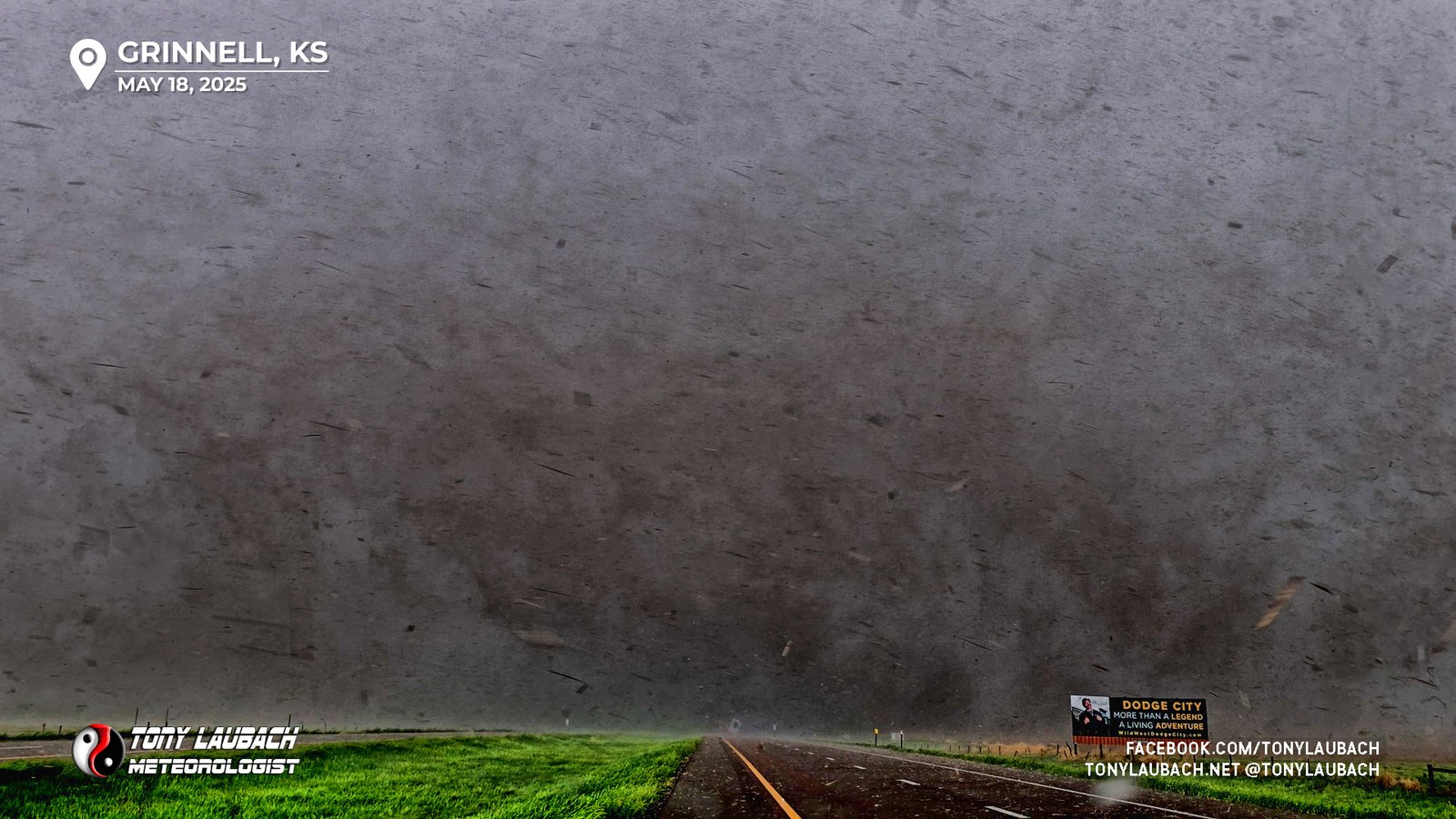
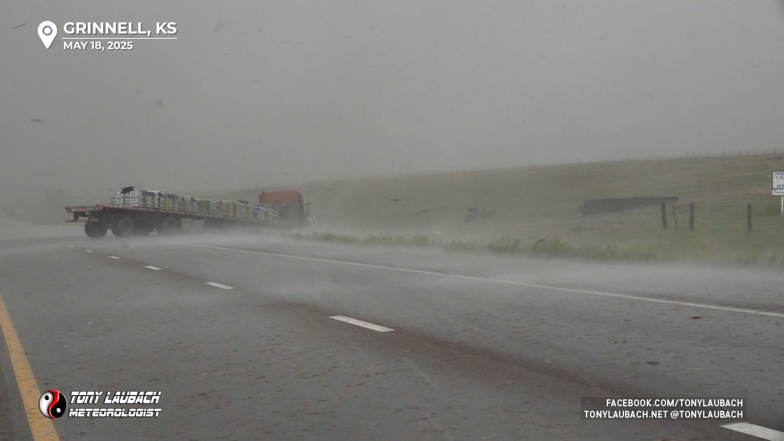
We came to a stop, being pelted with the field debris. Unfortunately a semi truck cruising east did not, and somehow did not bother to notice what was now glaringly obvious in front of him, and just before he disappeared into the tornado, we watched him get tipped and throw off the interstate.

We were helpless to do anything at that point; we couldn’t proceed until the tornado had crossed, but we were sure he was dead. Our last view of the semi before it vanished from sight was it being lofted off the embankment into the field on the south side of the highway. The tornado took what seemed like an eternity to cross, and we continued to watch as it made its way into the west side of Grinnell. It was a horrifying feeling knowing that town was about to get badly hit with this thing.
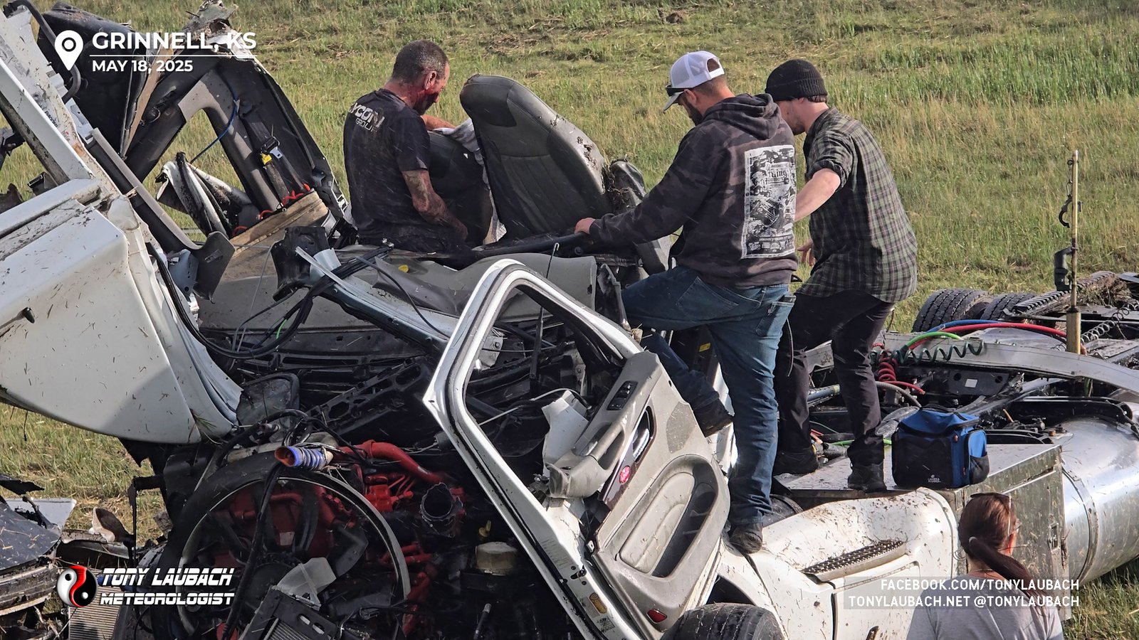
With debris still raining down on us, but the tornado now having cleared the interstate, or immediate priority was the truck driver. We made our way up slowly, approaching another semi that had pulled off on the right shoulder just in front of the tornado and it looked like it was smacked on the front end by what we assumed to be the semi we saw get thrown.
I was on the phone with 9-1-1 letting them know of the semis that were hit by the tornado and explaining that we witnessed one get thrown and the driver was likely injured and that Grinnell was also being impacted. We got around the red semi and pulled off in front of it. The precip and wind were dying down and we got our first view.
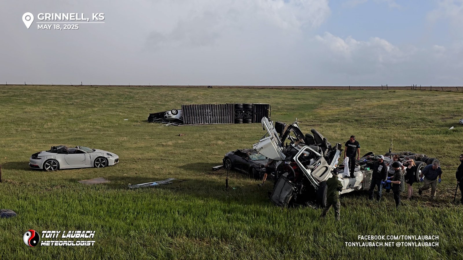
It was utterly horrifying… in the field was the mangled mess of the tossed semi; the driver completely exposed, bloodied and slumped over in what was left of his cab, completely mangled from the tornado. Honestly, we thought he was dead. What was even worse, it wasn’t the only vehicle in the field. About six other cars were scattered about, all mangled or flattened. My first though, oh my God, everybody’s dead.
I carry basic first-aid supplies in the car, and we immediately got out, unloaded the trunk to get to that gear and got ourselves ready. As we were gearing up, others began to arrive. I grabbed a towel and torniquet among other things and ran immediately first to the driver. He was alert, but injured. I checked on him, and he was buckled in and couldn’t get himself free. I told him not to move as responders were on the way (we could hear sirens and other people began to flock down). I couldn’t assess a safe way to climb up to him, so I tossed him my towel seeing as he was moving around and alert.
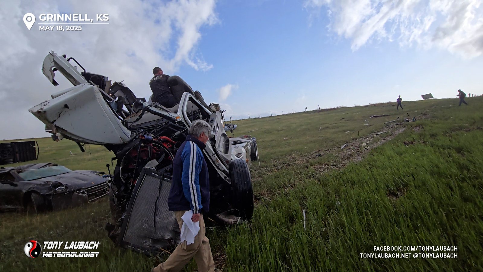
With him accounted for, I turned my attention to the nearest vehicle to the truck. I took a deep breath to brace for myself for what I thought I was about to see. When I got to the passenger side of the car and looked in, the vehicle was empty. In the moment, I didn’t make the connection, but suddenly the truck driver began yelling “those are my cars” and Ed connected the dots.
While we were eastbound prior to the tornado, we passed this truck and the trailer had a graphic on it saying something about luxury cars. Ed realized about that time that the six cars that were strew across the field were cars in his trailer that were ejected, likely when the trailer impacted the red semi parked on the shoulder.
I let out an IMMENSE sigh of relief… I turned my focus back to the truck driver after a quick visual scan of the other vehicles, seeing they all were basically the same model cars. By this point, an off-duty nurse had arrived among many others. The truck driver, still up in his cab, was telling his story as a couple folks were trying to climb up to him to no avail.
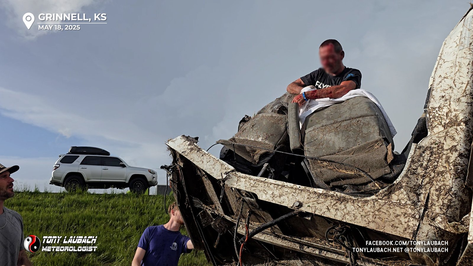
It’s worth mentioning as we were assisting down in the field, the tornado was udnergoing an INCREDIBLE sun-lit rope-out to our immediate north, but as we were occupied with helping out, neither of us got a shot of that. By the time we had cleared ourselves, it was long gone. But I remember vividly seeing my new vehicle silhouetted in the sun with the beautiful white rope-out going on behind it looking up at it from the bottom of the embankment.
Once the scene was secured by emergency officials, we pulled out of the area. Crews were already well established in Grinnell, so we didn’t want to get in the way of operations there. We went ahead and cleared the area. Other storms southeast of us were severe, potentially tornadic, so we figured that was probably the best move. It was a half-assed effort east toward Hays to get on those as we were still kinda reeling from the experience in Grinnell. The storms, fortunately, began to weaken as they neared the interstate, and with no additional effort from us, we continued on to Salina where we bunked down for the night.
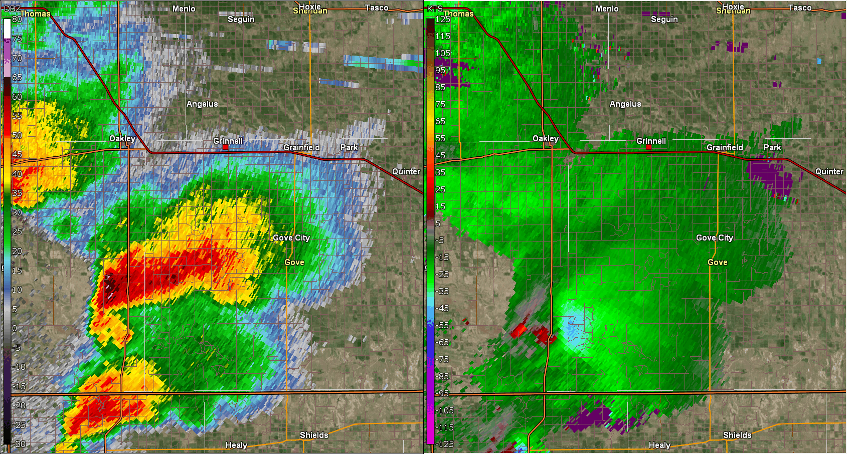
The radar animation below highlights the Grinnell tornado, but in the first few frames, you can see in the velocity scan on the right the end of the Scott Lake tornado we mostly missed while in the Canyon. The northern cell (Grinnell) had a very strong velocity couplet we assumed was the original wedge we intercepted prior to Scott Lake, but what ended up happening was when we saw the initial wedge disappear, it likely had dissipated, the storm cycled as it crossed US-83 to our north while we were playing with the Scott Lake stuff, and the Grinnell tornado would touch down a few miles south of I-70/Grinnell likely as we exited Oakley. This would ultimately be our sixth and final tornado of the day, even as we thought it was still the initial wedge.
The intercept at Grinnell easily ranks in the top intercepts for me, certainly one of the most, if not THE most intense intercept of my career. The tornado was rated EF-3, the strongest of the day in our neck of the woods. While the tornado itself was memorable, it was the moments immediately following that stick out the most to me. Thank God that was not worse. The truck driver survived by the fact that had that tornado impacted something more significant and was hurling around larger debris, there’s no way he would’ve survived. Only because the tornado was only hurling lighter field debris did he survive being exposed like that. Grinnell itself was significantly impacted, mainly on the west side. From the interstate, it looked bad, but fortunately everyone impacted survived.
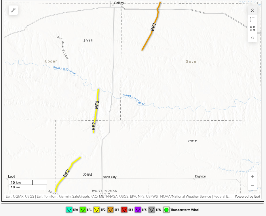
The initial wedge and the Scott Lake tornado were both EF-2. The others were unrated as they either hit nothing or were super brief. In total, Ed and I witnessed six tornadoes on the two Scott/Grinnell supercells. A helluva end to what was a legendary stretch of chasing, and the biggest day in Kansas since probably 2016 if you include what happened later in the evening outside Greensburg.
A lot of chasers busted this day as many targeted south-central Kansas and waited too long to make a play on the Oklahoma tornadoes. A few managed the after dark stuff near Greensburg. We made a very smart and timely call, despite the delayed lunch, to get west out of Great Bend and “keep going til we see sun”. We didn’t wait for the clearing, we went straight to it, and I’d argue we had the storm of the day despite the picturesque nature of Oklahoma. A shocker of an event in that area considering where most of the early targets were set up. None-the-less, May 18 will be a day never soon forgotten by either of us.