
A pretty no-brainer target in northeast Colorado as most hi-rez models had this pinned for nearly two days. Of course, one can’t assess the QUALITY of the storms that would come out of this ahead of time, and boy this one certainly did not dissappoint.
Left home shortly before noon and made the hour drive over to Brush for lunch and a little work before finishing my trip to my target of Sterling. Despite most models initiating the storm near Kimball, I opted to sit tight south of that point knowing the storm(s) would be moving south and I’d rather be ahead than trying to navigate in/around a core I knew would have large enough hail to make a mess.
Killed a couple hours in Sterling as several storms developed east of Cheyenne, but it was the one that formed south of Kimball that would be the game. Ed Grubb met with me and we caravanned up CO-113, not quite getting to Peetz, then took a series of dirt roads back west to get a better view of the target storm that was over near CO-71.

We followed it southward as it cycled a couple times, eventually getting back to Sterling and ducking further south on US-138 to Atwood, setting up just south of the I-76/CO-63 junction. We figured this was gonna be target highway for the first part of the day.
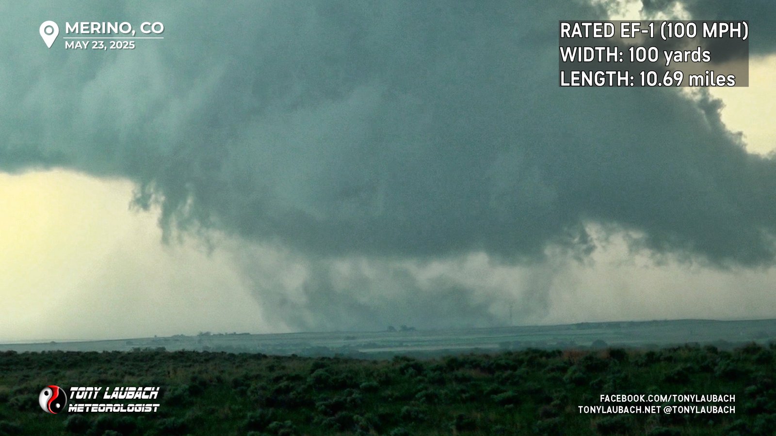
We set up and watched the storm make its approach. Several times prior to this, the storm would spit out gustnadoes, but eventually did pull itself together to form a weaker looking tornado (perhaps landspout) toward Merino.

We observed this for several minutes, waiting for it to get on our side of I-76. This particular feature lessened, and ground circulation became much more diffuse. Shortly after this, another such feature developed. As it was much closer, it had more obvious cloud-based rotation to it, although the ground circulation wasn’t as condensed.

Whether this was the same circulation or different remains to be seen; I consider this to be a continuation of the one we saw near Merino, but one could easily convince me this was a separate.
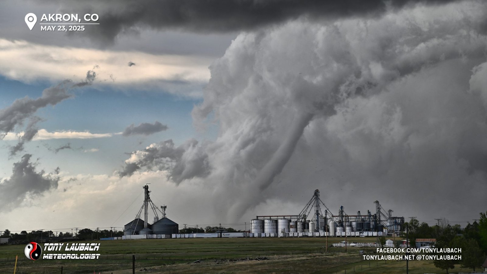
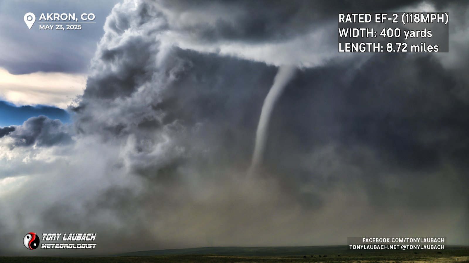
At this point, Ed and I got separated; me diving south in hopes that I could set myself up closer to Akron so I could make the east run ahead of the core to get east out of Akron to a manageable north/south road. As I was doing this, I happened to catch a glance in one of my side mirrors of what looked to be a HUGE tornado now ongoing to my north. I immediately flipped around and fled back to the north to close some of the distance I had put between me and this now new tornado.

I didn’t have the greatest contrast, and this was one of the few times my naked eye was observing this better than any camera I could put on it, but with a little work (okay, a lot), I was able to bring about some definition to what was otherwise mediocre captures. I probably drove five, maybe six miles or so to close the gap, watching this MASSIVE dust whirl and associated clouds merry-go-around like mad to my north.

As I got toward the end of my run, the actual tornado started to reveal itself out from behind this massive dust wall. I was on a bit of a hill overlooking the road to my north and I saw an endless number of vehicles dotted along the route. Figuring there’d be limited places to safely pull over and not wanting to get stuck someplace where the large hail core or (even worse) the tornado would catch me, I decided to take the vantage point I had and do my best, which turns out wasn’t too shabby at all.


As the tornado neared CO-63 to my north, it once again pulled the veil of dust across itself, masking it from view. I quickly turned myself back around to the south and rolled into Akron, well ahead of the chaser congo line. I got about a mile south of Akron when once again, my side mirror revealed the tornado (I assume it to be the same one). I immediately pulled off into the nearest pull-out and had a very cool view overlooking the town as the tornado roped out to its immediate north.

The rope-out was something else, and I had a good view as it did. I sat until the last bit of the funnel vanished, then once again proceeded south. There was some irony for me along this stretch south of Akron as this was the area I witnessed 19 tornadoes on back in 2023, and I eventually arrived to the very spot I saw for the twins showing, waiting for the storm to cycle and make its next approach.
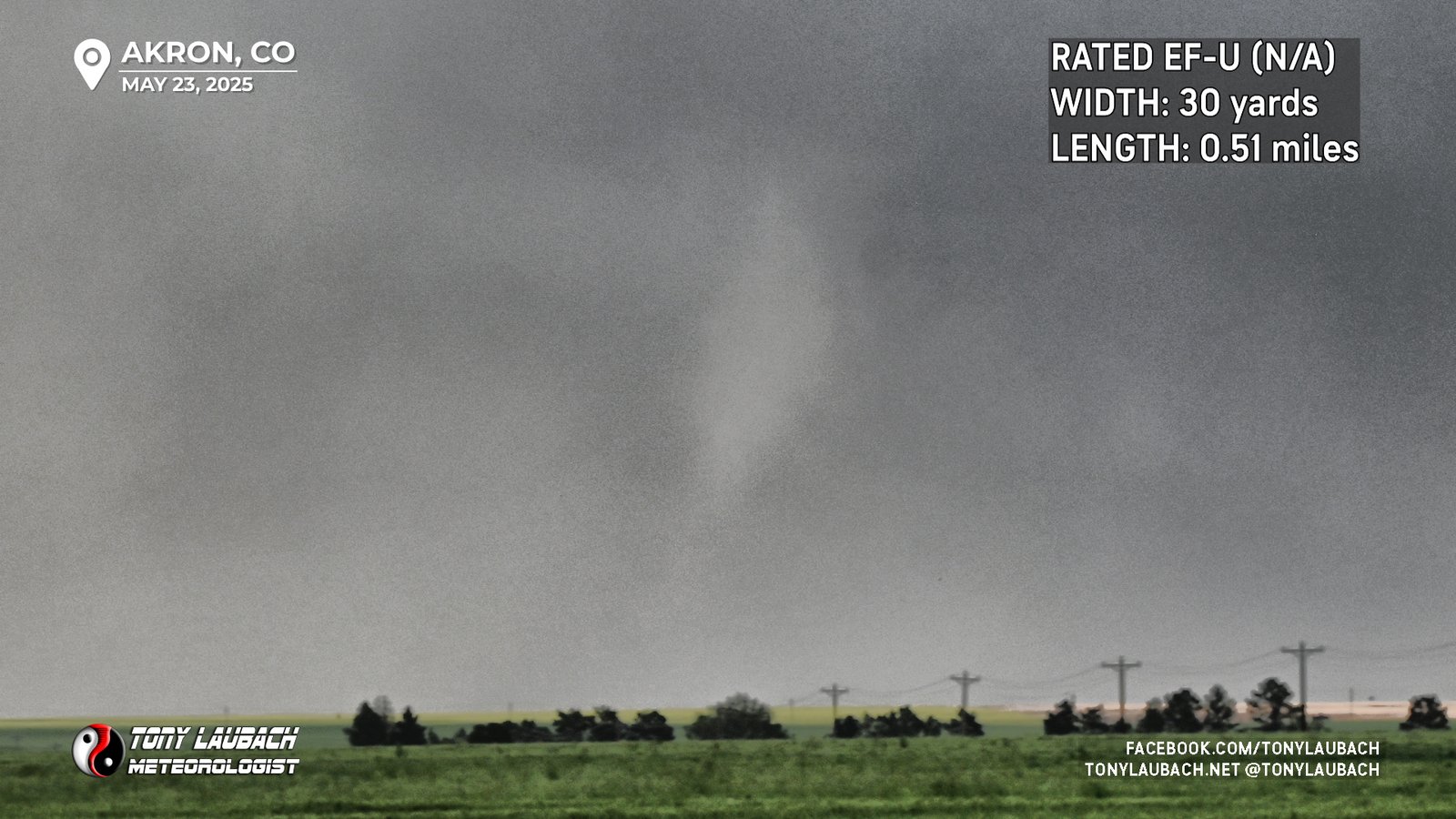
By this point, the storm was presenting itself less on radar, but a brief tornado did touch down well to my north that my video couldn’t get to save its life. But my Nikon, and again with some tedious work, could bring out just enough to prove it was there.

This didn’t last long, and based on reports I was seeing, it was pretty weak and didn’t offer anything too spectacular. But the storm was now pushing in a more easterly direction, so I jumped back north and re-met Ed. We headed east on CR-37, a dirt road about 3-4 miles south of US-34 to try and get back ahead of the notch/hook area. We got south of Platner as the storm was both visually and on radar, showing signs of weakening. We enjoyed the rainbow on the backside of the storm with Dave Mayhew before we all parted ways, me getting back up to US-34 and making the short drive home with a Taco Bell stop in Fort Morgan along the way.


The National Weather Service in Boulder surveyed the three tornadoes giving each a rating based on the damaged observed. The Merino tornado was confirmed to be one single tornado as opposed to two correcting my previous assessment.
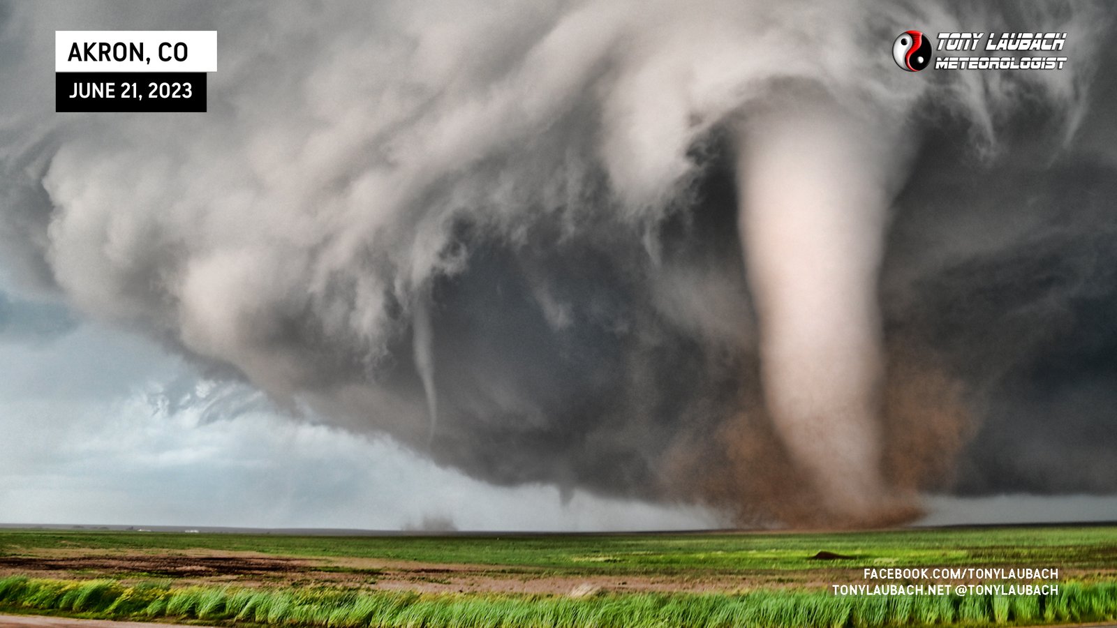
I am a few days away from getting a coating of Line-X on the new ride, so I’ve been out-of-character avoiding hail cores, and I was probably a bit too eager to get ahead of the storm as to avoid the large core within (and I have heard some stories of significant vehicle damage from some of that hail, so I am happy I did). I’d say I easily could’ve been closer or better positioned and likely stay unscathed, thus allowing me better opportunities for much better images. I’d be lying if I said some of my underwhelmingness stems from my last several chases offering some INCREDIBLE imagery, so I felt a bit meh when compared to such recent successes (and of course comparing to what others have of this tornado), but it definitely does not take anything away from the day as a whole. An incredible Colorado tornado, reminding me very much of Yuma 2023, that I managed to get a couple wall-worthy shots. In the end, it’s a steak-worthy day with absolutely no complaints on my end, even if I stick my nose up at the imagery I collected. Haha
It’s been an incredible run for me since getting the new ride… she is 5 out of 7 chases with 16 tornadoes, many of those being exceptionally high quality. This also marks my first Colorado tornadoes of the season, a late start here, but I wishfully assume I’ll add to that count as we get into our peak season here in the High Plains.
I will say, Akron 2023 was world’s better, so this offered up a nice consolation prize to the MANY folks who were on this storm. But while this was fantastic (again, probably on the level of Yuma 2023), this was not Akron 2023… sorry, not sorry folks…