


Two things right off the bat… first, this was the single most dumb lucked-into tornado of my career. Nothing leading up to this intercept was planned and by pure chance and amazing timing, did I roll up on this.
Secondly, this was NOT the Cheyenne Wells storm that every chaser had been pursuing prior. That supercell moved up from the Lamar area and passed just to the west and north of Cheyenne Wells, leading most everyone up toward I-70 and Burlington. This tornado came out of a developing line of cells to the south of that cell, eventually crossing US-385 south of Cheyenne Wells. Two very separate storms.
I started the day in Garden City after what was essentially a non-chase the night before. I departed the area around noon, heading due west toward Syracuse in extreme western Kansas. There, I took some time to set up the car, gas up, and do my usual pre-chase prep work. Meanwhile, a tornado watch went up for the CO/KS border area as storms began to fire across northeast New Mexico and southeast Colorado.

 The first storm I went after was a juicy meatball that was producing some hefty hail near Springfield, Colorado. I drove south to Johnson City, then cut due west from there on a paved county road, crossing the border into Colorado and stopping at Lycan where CO-89 and CO-116 met. The storm, as if it sensed my arrival, immediately collapsed, leaving nothing but light rain to fall as it moved into Kansas as a puff of its former self. I took CO-89 north to Holly, then cut back east to Syracuse.
Other storms were forming across eastern Colorado, including several in the La Junta/Lamar area. Meanwhile to my north, a large cluster of storms started to get some steam. Being I was ultimately needing to go north, I jumped on K-27 and went through Tribune on my way to Sharon Springs. About the time I arrived, a tornado had been reported southwest of Colby. Still concerned about the haul to get far enough west on the Colorado storms, I thought it would be more convenient to try and catch the I-70 stuff as it would start my drive home.
At this point, I was seeing the biggest issue I thought would hinder today coming to light. Too many storms too soon, and it was evident, even as the Colorado storms had only produced a couple brief little tornadoes to this point. I was sitting in 55-degree air, and all the good storms in Colorado were making a run at very worked-over and cold air in the wake of these storms.
So yes, this was day ending number one for me. But I stopped in Winona (south of Levant) to reconsider the west play. To this point, I had limited myself to Kansas for work, but those storms were continuing their run at Kansas, and even if the air was crap, they’d pose a threat. A phone chat with my Chief Met helped push me back to the west.
I rolled through Sharon Springs and was planning to stop in Weskan as to not give up the KS-27 route to catch the storm north. But that cell was taking its sweet time. Storm speeds had slowed, and I figured I’d be waiting til next Tuesday for that thing to get into Kansas, so I crossed the border and headed toward Cheyenne Wells.
At this point, I was seeing a bunch of small convection forming ahead of the supercell’s inflow, so I started to grow concerned whether this storm would survive. As I approached Cheyenne Wells, I got myself introduced to what became known as the Chaser Conga Line. Dozens, if not hundreds of chasers were scattered around town. Originally, I was going to drop a bit south on US-385, but seeing the crowds, I wondered if I got stuck in that if I’d get out in a timely manner. With that in mind, I opted for the west side of town where passed the northbound US-385 junction, so I would have a very clear return to the highway and right of way access to whatever route I needed back to the east.
I found a parking area a few miles west of US-385NB and met up with long time friend and fellow Colorado chaser, Eric Treece. We chatted for a bit as the storm approached from the south, but standing outside in the very cold inflow, we both were pretty poo-poo on this storm. By this point, I was now in my second round of calling it a day.


So getting a little low on fuel and the way-outside-chance of intercepting a quality storm moving into southwest Kansas, I decided I’d take the south route home to Wichita, with my target fuel stop in Tribune. I decided to part ways with this storm as it continued to move northeast into even chillier air (mid 50’s along I-70). I began my southbound run from Cheyenne Wells on US-385, passing the back-end of the conga line of chasers as they streamed into town from the south.


As I got a couple miles south, I kept seeing what was a developing wall cloud with the storm. It was enough to get me to turn around and hold for a few moments to observe. While further away, I still had a pretty good view. The rotation became very rapid, so I decided to grab a waist and join the conga line. By this point, most of the chaser crowd was either in town or making their final drive up to Burlington. I didn’t have much issue getting back to town.


I did follow this storm a few miles north of Cheyenne Wells, but visually, the storm was quickly losing the spunk it was trying to harness, so I pulled off the highway and decided it was time to go with my Tribune plan. I was on the phone with the station and chatting with them about my plan, telling them I was going to take US-385 as it was more direct as opposed to US-40 which had a northwest vector to Sharon Springs.
So once again, I was southbound. By this point, most of the chaser conga line was northbound out of Cheyenne Wells, with a large handful jockeying for fueling positions as the few gas stations in town. I turned south on US-385 and was once again calling it a day in my head.
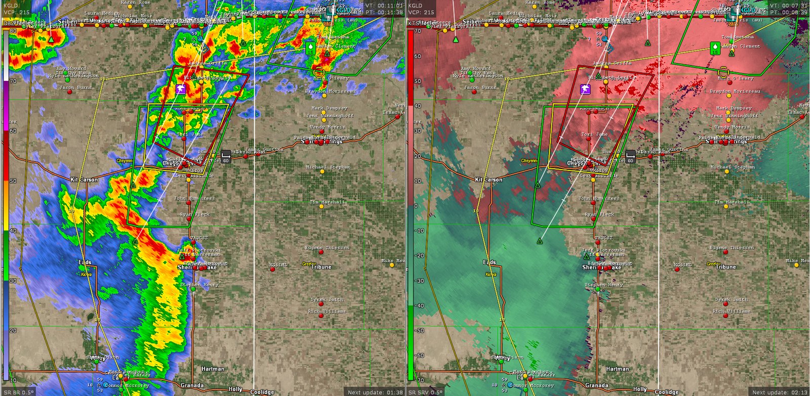
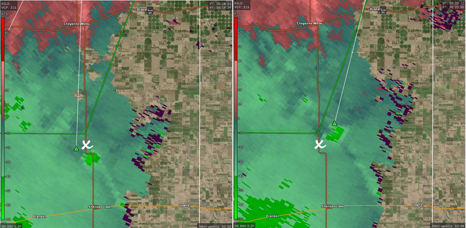
So I’m driving, seeing the developing line of storms to my southwest. A little appendage had started to developed ahead of the line to my south. Now I truthfully hadn’t given this any real thought as it was the first scan to show this feature. While it had a look on reflectivity, there was no apparent rotation with it, so I just assumed it was some crud developing ahead of the line.
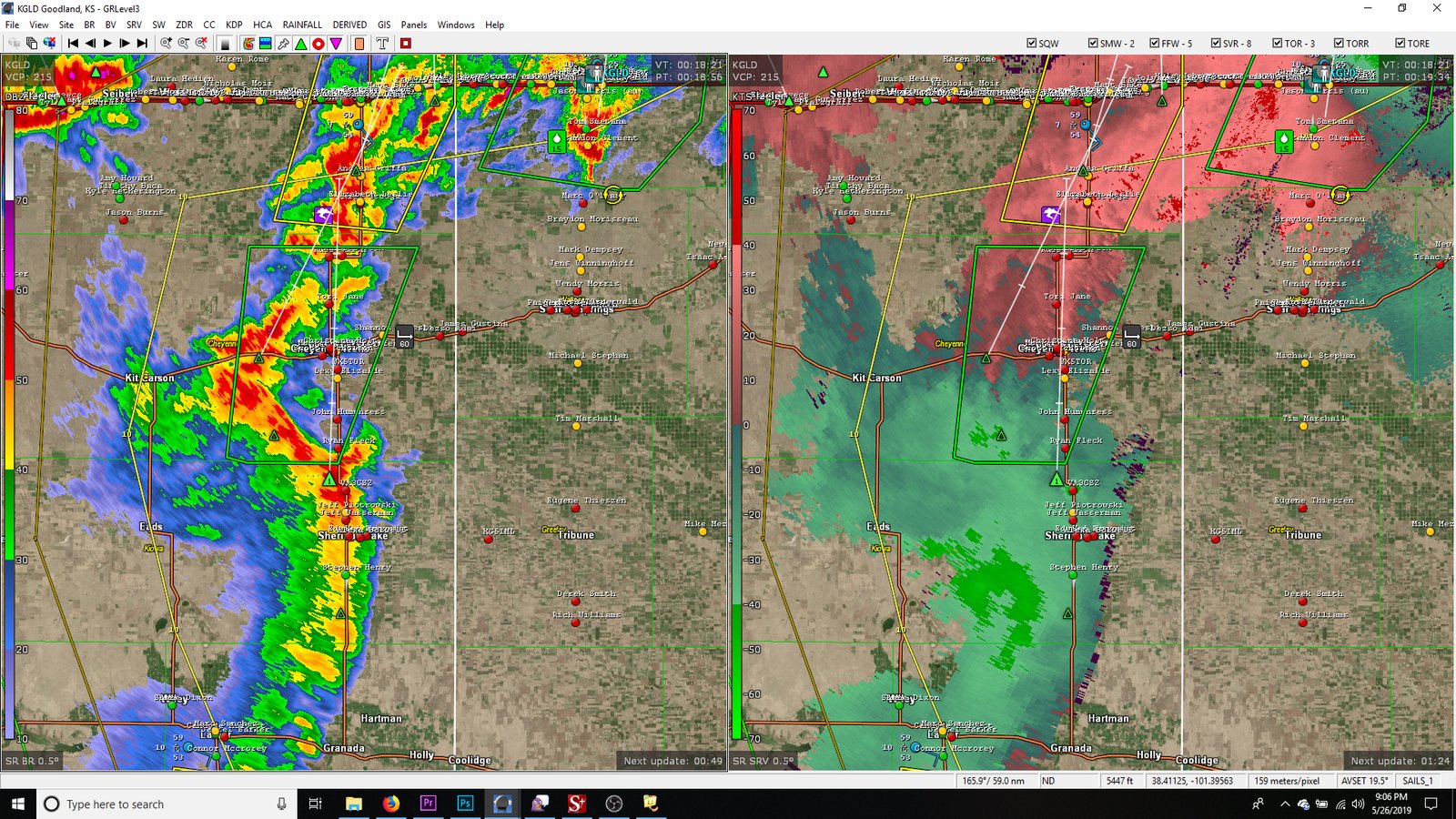
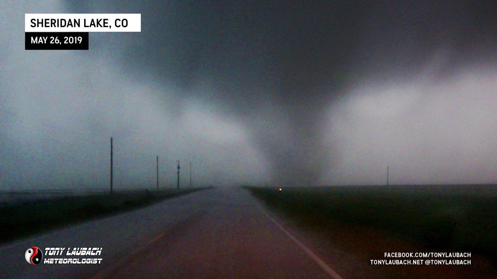
Obviously at this point, I was driving through that appendage into the rain. As I continued south of the county line, I observed a darkening area in the rain off to my southwest. My first thought was rain curtain, but realizing quickly I was in the rain and that this shape appeared a little too perfect, I began to suspect.
I slowed down (a lot), and as the tornado and I closed distance, I could make out the circulation and the rising motion in the vortex. It was a tornado. Seeing movement from my right to left, I knew it was going to cross the highway harmlessly to my immediate south. I crawled to the intersection of CR-Z and US-385 (8 miles north of Sheridan Lake), stopping to observe the tornado in the field next to me. The contrast was exceptionally low, but the motion with this tornado was pretty cool to see up-close. It moved to my east into the field next to me, then eventually continued northeast and quickly vanished back into the rain.


I had a view of this tornado for roughly 90 seconds, and as quickly as it appeared to my south, it disappeared to my northeast. I do not know how long that tornado continued after I lost visual, but based on radar analysis, I do not imagine it held out very long as the velocity signature was present for only a couple scans, disappearing shortly after my encounter.
I pulled into the farm lot after the tornado cleared and took a few moments to make my report, tweeting an image to the NWS to which prompted a tornado warning as the storm moved into Cheyenne County, Colorado.
Once the line had cleared me, I continued with my plan, heading east out of Sheridan Lake toward Tribune. The line of storms that produced that tornado continued to my northeast and I was beneath a pretty cool whale’s mouth. I stopped for a shot before continuing into Tribune for fuel and food.

After a lengthy stop to get fuel, food, and edit some video, I headed south for my THIRD roll through Syracuse, then turning east out of there for Garden City. Meanwhile, a line of storms was developing to the south and moving northeast. It was also starting to fill in on me as I arrived into Garden City. The line intensified very fast, and reports of winds over 70mph were starting to trickle in from the south (Liberal hit 77mph).
Initially, I was hoping to just get ahead of the line, but it was hauling fast enough where there was no chance. It started to catch me as I rolled through Cimarron. Power went out in town as I was going through, and I saw power flashes to my southwest. Those power flashes on the leading edge of the line basically chased me into Dodge City where I got parked in a hotel parking lot on the far west side less than two minutes before the line arrived. One more very bright power flash and the entire west side of town was without power. Winds hit me that were in the neighborhood of 60mph, and they lasted a few minutes.


I ventured around town to assess any damage and saw very little. Some of the roads were a little flooded, but even that was relatively minor all things considered.


Opting to not have to drive in a downpour the rest of the way, I let the line get about 30 miles ahead of me and continued home, pacing the line as it rolled into Wichita. I got home around 2:30am, 690 miles in a 14.5 hour stint of time.
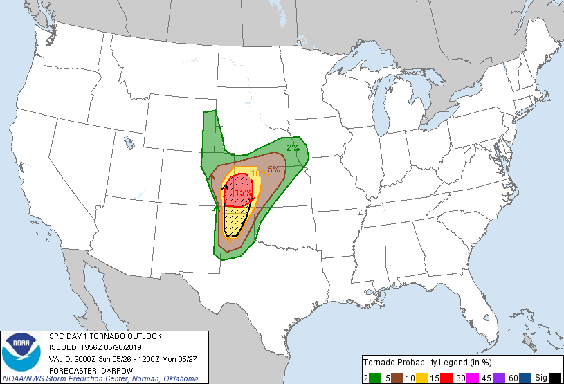
In an era of chasing that we’re in, to be the ONLY person to witness a tornado is exceptionally rare and a very cool bragging right. Particularly on a SPC-issued moderate risk day within a 15% hatched tornado bubble where hundreds if not thousands of other storm chasers were running around. To add some icing to that cake, most chasers had just vacated this area within 30 minutes of this tornado, most of them arriving in Cheyenne Wells (north of the tornado) after pursing the Lamar storm into the area. What I observed, by complete dumb luck and timing, occurred in developing storms south of that. Aside from one northbound car passing me in the early stages of me seeing the tornado, there was not a single other vehicle anywhere in sight. I was truly the ONLY person to witness and document this tornado. That badge I’ll wear with pride considering how many chasers were easily within 30 miles of this.
This chase won’t make any top 10 list (except maybe dumbest luck tornado), but it was a very cool experience and a nice payoff for what had been a frustrating stint over the week prior. This was definitely an experience tornado as visually it was a true needle in the haystack. I was happy to turn the imagery I did given the conditions. Overall, this setup largely under-performed across the main risk area. The storm of the day was easily down across New Mexico and around Lubbock later that evening. Up in the main area, just a few weak tornadoes occurred, this one being as weak as any of them, likely nothing more than a very wet circling wind. Still, it capped off a very long day with an exceptionally memorable tornado, one that I will forever be the ONLY one to have been there for 😀


