
TONY'S TORNADO CHASES
A List of My Best Tornado Chases
This is a collection of my best tornado chases throughout my storm chasing career. These date all the way back to 2003 and include some of the most prolific tornado events in storm chasing history!
MY TOP 5 TORNADO CHASE DAYS
CLICK HERE TO SEE MY FULL TORNADO LIST
A cyclic tornadic supercell from New Mexico produced a family of tornadoes on its way to Lubbock, including a monster, career tornado near Morton, Texas.
• TORNADOES: 10
• MAX HAIL: None
• FLOODING: Observed
• Lightning Imagery: Not Captured
In Progress
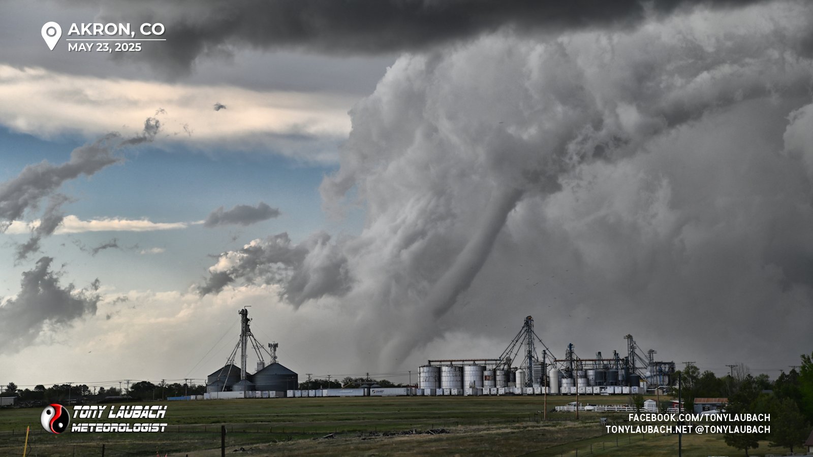
Chase Log: May 23, 2025
Three Eastern Colorado Tornadoes During Akron 2.0!
Northeast Colorado (339 miles)
On a chase that reminded me a lot of Yuma 2023, I saw several tornadoes, including a long-lived, very photogenic tornado near Akron in northeast Colorado.
• TORNADOES: 3
• MAX HAIL: None
• FLOODING: Observed
• Lightning Imagery: Not Captured
Full Write-Up

Chase Log: May 18, 2025
The Intercept Of a Lifetime on a Kansas Tornado Outbreak!
Northwest Kansas (654 miles)
In one of the largest tornado outbreaks to hit Kansas in the last decade, we had one of our most intense tornado encounters of our careers. And oh yeah, wedge-fest to boot!
• TORNADOES: 6
• MAX HAIL: 1.00
• FLOODING: Observed
• Lightning Imagery: Not Captured
Full Write-Up
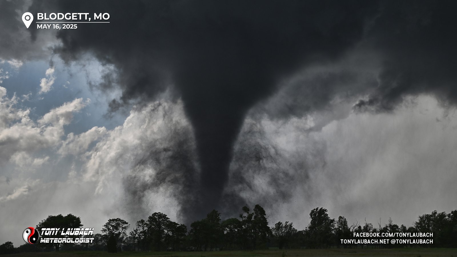
Chase Log: May 16, 2025
My Best Ever Tornado Chase/Encounter in Southeast Missouri!
Southeast Missouri (611 miles)
Incredible intercept of a large, high-contrast tornado that crossed I-55 north of Sikeston; one of three tornadoes I would document in southeast Missouri in this localized tornado outbreak.
• TORNADOES: 3
• MAX HAIL: 0.88"
• FLOODING: Observed
• Lightning Imagery: Not Captured
Full Write-Up

Chase Log: May 14, 2025
Western Nebraska Spout-Fest On The New Ride's First Chase!
Western Nebraska (851 miles)
Spout-fest in western Nebraska as I observed three of the multiple landspout tornadoes that dropped from a slow-moving supercell west of North Platte.
• TORNADOES: 3
• MAX HAIL: 1.00"
• FLOODING: Observed
• Lightning Imagery: Not Captured
In Progress
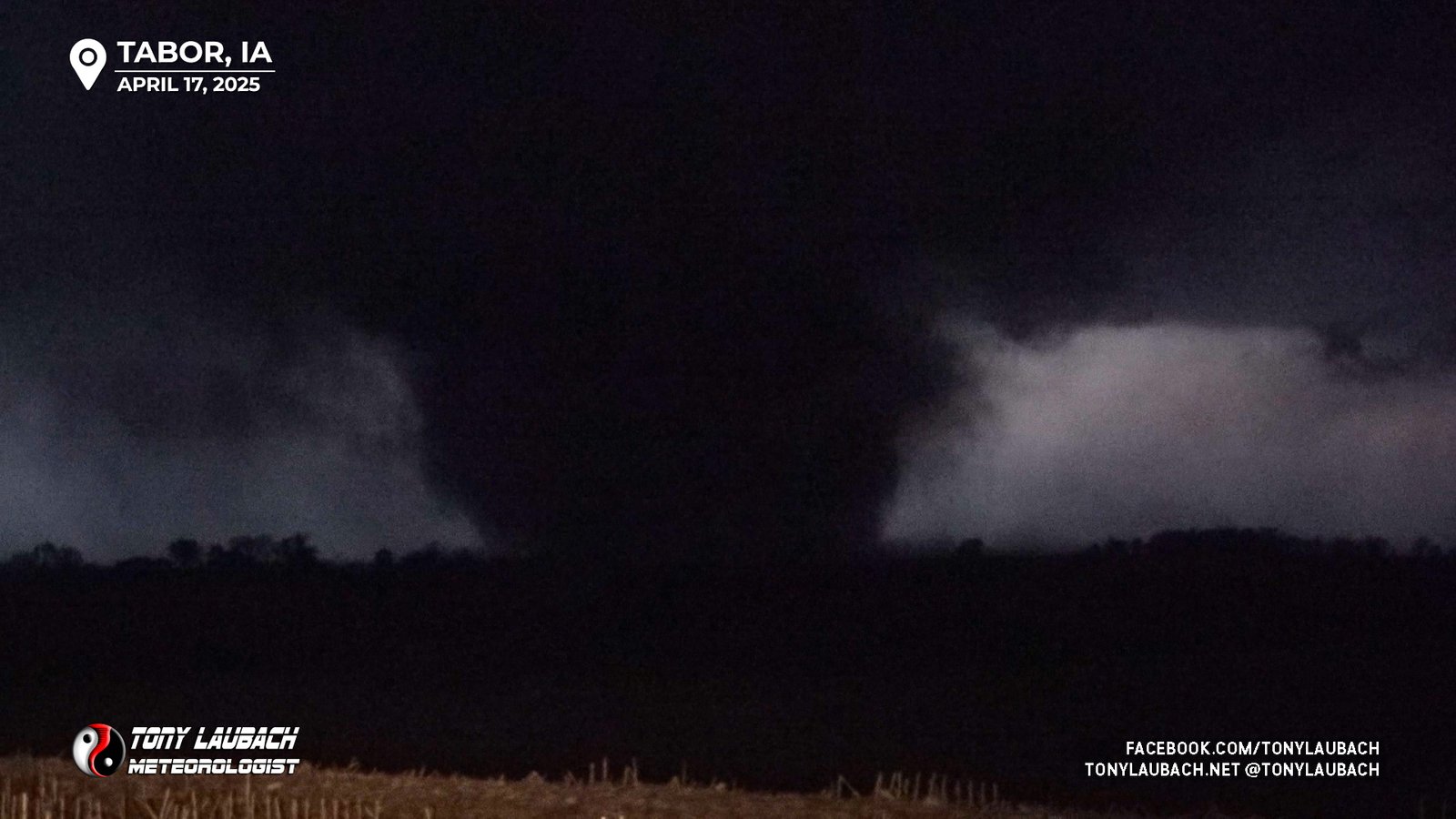
Chase Log: April 17, 2025
The Massive Iowa Tornado Didn't Get Me, But The Hail Did!
Southeast NE/Southwest IA (757 miles)
A 'Hailuva' chase that included two weak landspout tornadoes and a large tornado after sunset in southwest Iowa. But monster hail in both states yielded the biggest remembrance of this day.
• TORNADOES: 3
• MAX HAIL: 4.00"
• FLOODING: Observed
• Lightning Imagery: Not Captured
In Progress
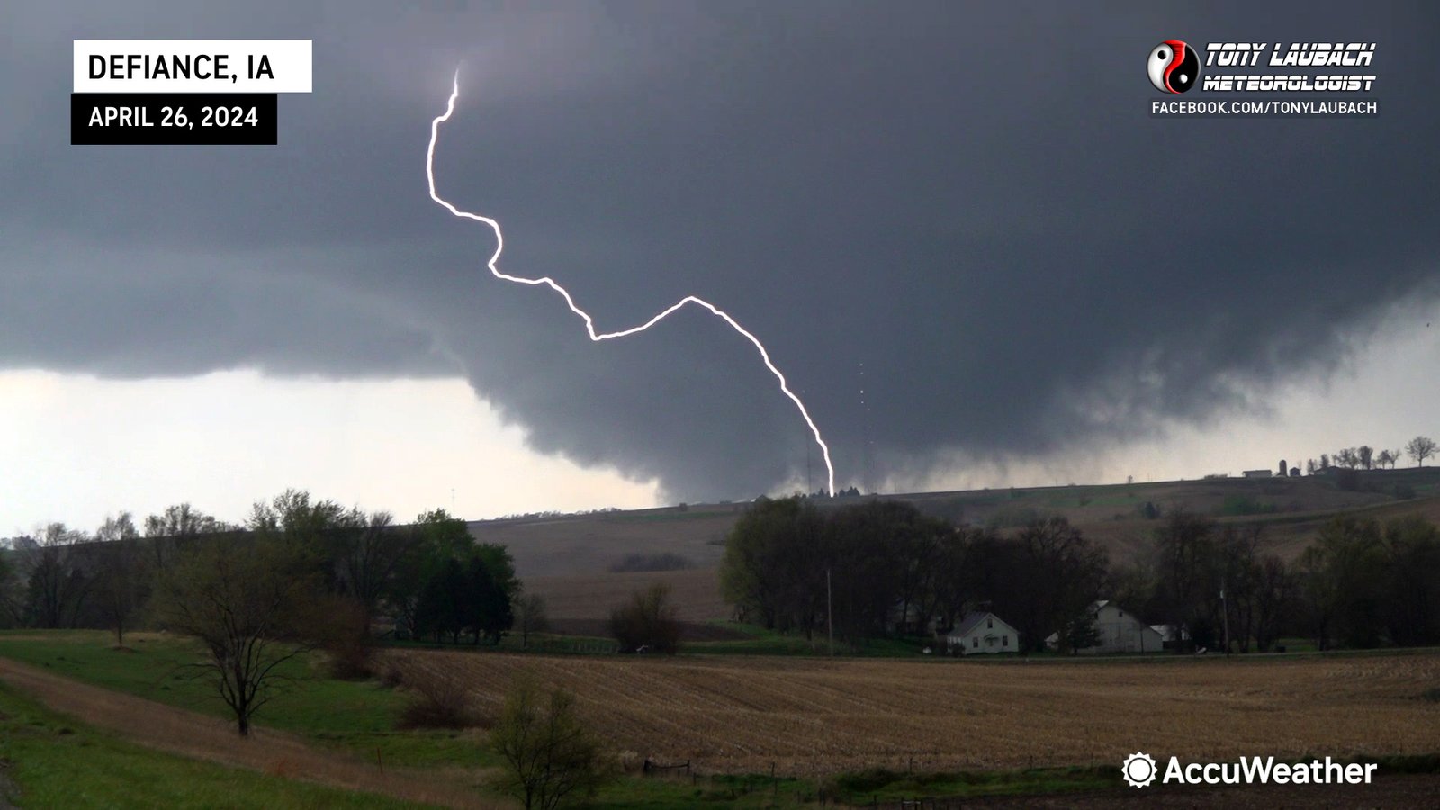
Ed Grubb and myself chased the largest tornado outbreak of 2024, documenting 8 tornadoes across Nebraska and Iowa, and covered a large tornado live for 30 minutes straight.
• TORNADOES: 8
• MAX HAIL: 1.50"
• FLOODING: Observed
• Lightning Imagery: Not Captured
Full Write-Up

Chase Log: August 8, 2023
Northeast Colorado (551 miles)
In a season full of incredible tornado chases, why not have another one! Incredibly photogenic tornado intercept near Yuma that I did a live standup in front of.
• TORNADOES: 4
• MAX HAIL: 3.00"
• FLOODING: Observed
• Lightning Imagery: Not Captured
Full Write-Up
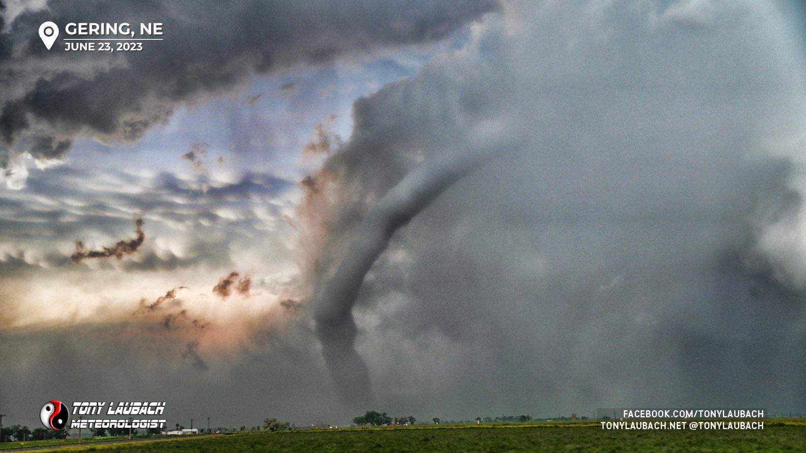
Chase Log: June 23, 2023
Eastern WY/Western NE (449 miles)
In any other year, this would've been a top day, but two days after Akron, this SEVEN tornado day was just going through the motions, but added to an already career season!
• TORNADOES: 7
• MAX HAIL: 2.00"
• FLOODING: Observed
• Lightning Imagery: Not Captured
Full Write-Up
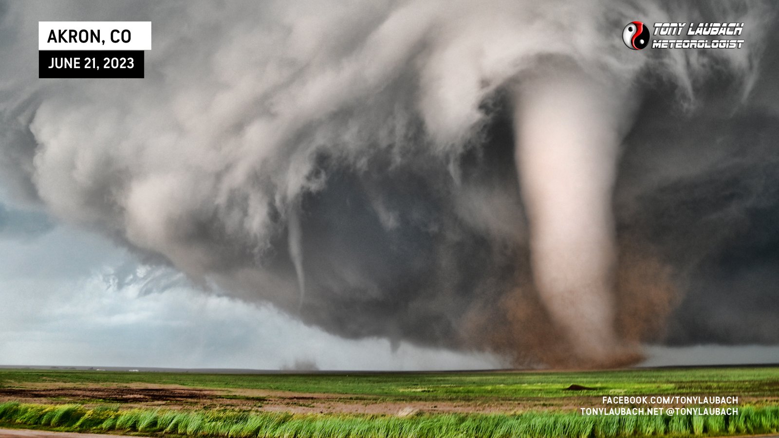
Chase Log: June 21, 2023
I Saw 19 Tornadoes in Colorado on the Best Tornado Chase Ever!
Northeast Colorado (383 miles)
The tornado chase of my lifetime, hands-down the all-time number 1! One of the most beautiful tornadoes ever photographed, one of nearly THREE dozen to touch down on this historic Colorado day.
• TORNADOES: 19
• MAX HAIL: 2.75"
• FLOODING: Observed
• Lightning Imagery: Not Captured
Full Write-Up
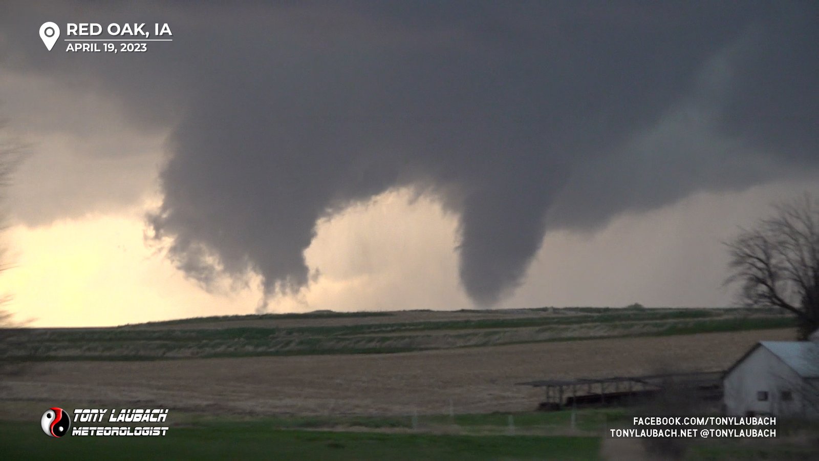
Chase Log: April 19, 2023
Southwest Iowa (0 miles)
Another Iowa chase, another Iowa tornado! This part of a trifecta that included monster hail and some great lightning photography!
• TORNADOES: 1
• MAX HAIL: 2.50"
• FLOODING: Observed
• Lightning Imagery: Captured
Full Write-Up
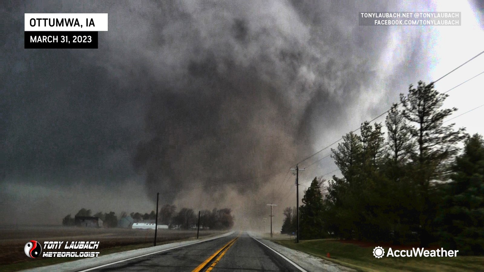
Chase Log: March 31, 2023
Southeast Iowa (755 miles)
Any shred of my Iowa curse left was absolutely annihilated when Ed Grubb and I had a top 10 career tornado intercept outside Radar O'Reilly's hometown of Ottumwa on a massive, close-range EF-3 monster!
• TORNADOES: 1
• MAX HAIL: None
• FLOODING: Observed
• Lightning Imagery: Not Captured
Full Write-Up
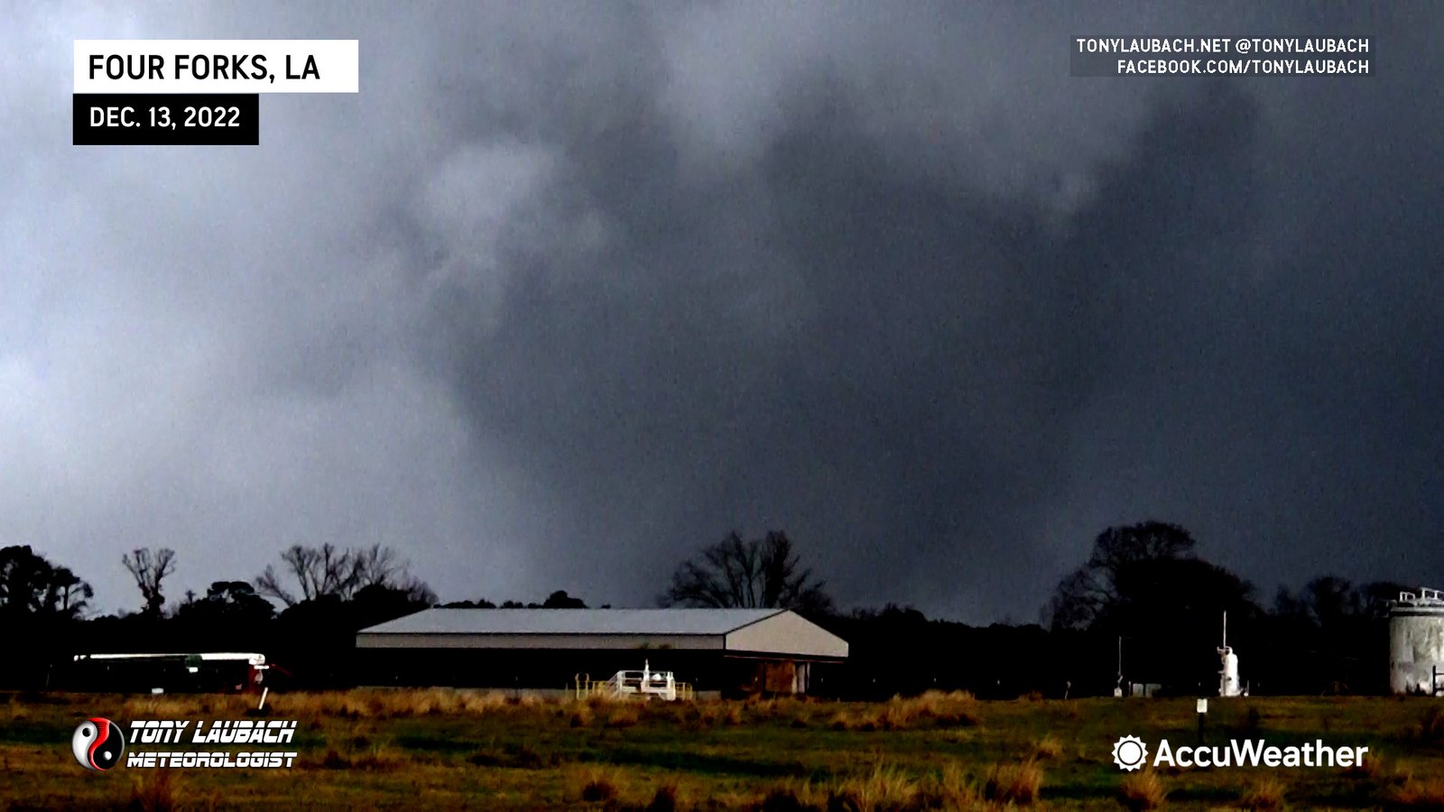
Chase Log: December 13, 2022
Eastern TX/Northern LA (683 miles)
This chase was full of firsts as Ed Grubb and I documented our first ever December tornadoes, including our first Louisiana tornado near Four Forks.
• TORNADOES: 2
• MAX HAIL: None
• FLOODING: Observed
• Lightning Imagery: Not Captured
Full Write-Up

Chase Log: November 4, 2022
Northeast Texas (2,234 miles)
A large November tornado outbreak across northeast Texas brought an incredible, close-range intercept of a large, very photogenic EF-2 tornado southwest of the town of Sulphur Springs for Ed Grubb and I.
• TORNADOES: 1
• MAX HAIL: 1.00"
• FLOODING: Observed
• Lightning Imagery: Not Captured
Full Write-Up
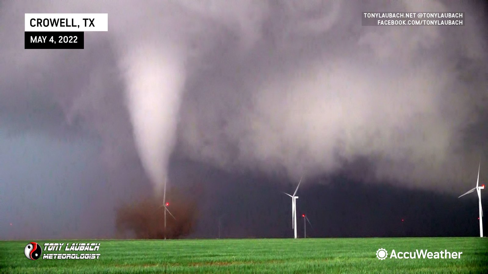
Chase Log: May 4, 2022
Northwest Texas (873 miles)
Ed Grubb and myself chased a pair of Texas tornadoes, one a beautiful cone that ripped through a windfarm near Crowell. We documented damage the following day in Lockett.
• TORNADOES: 2
• MAX HAIL: None
• FLOODING: Observed
• Lightning Imagery: Not Captured
Full Write-Up
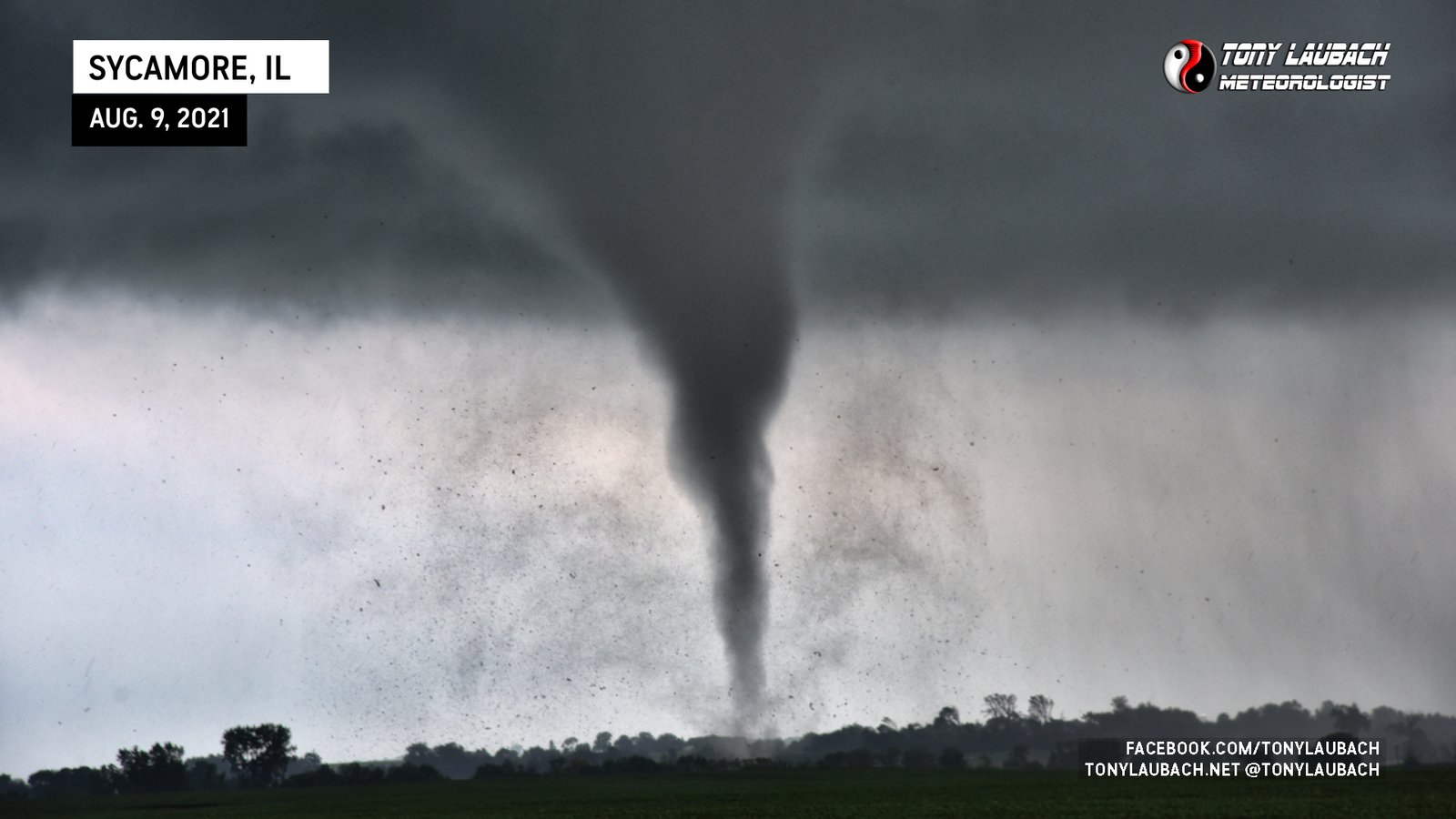
Chase Log: August 9, 2021
Northern Illinois (491 miles)
A rather low-end setup yielded my best ever Illinois tornado chase day; half a dozen very photogenic tornadoes all within a few hours of each other on an localized northern IL outbreak day.
• TORNADOES: 6
• MAX HAIL: None
• FLOODING: Observed
• Lightning Imagery: Not Captured
Full Write-Up
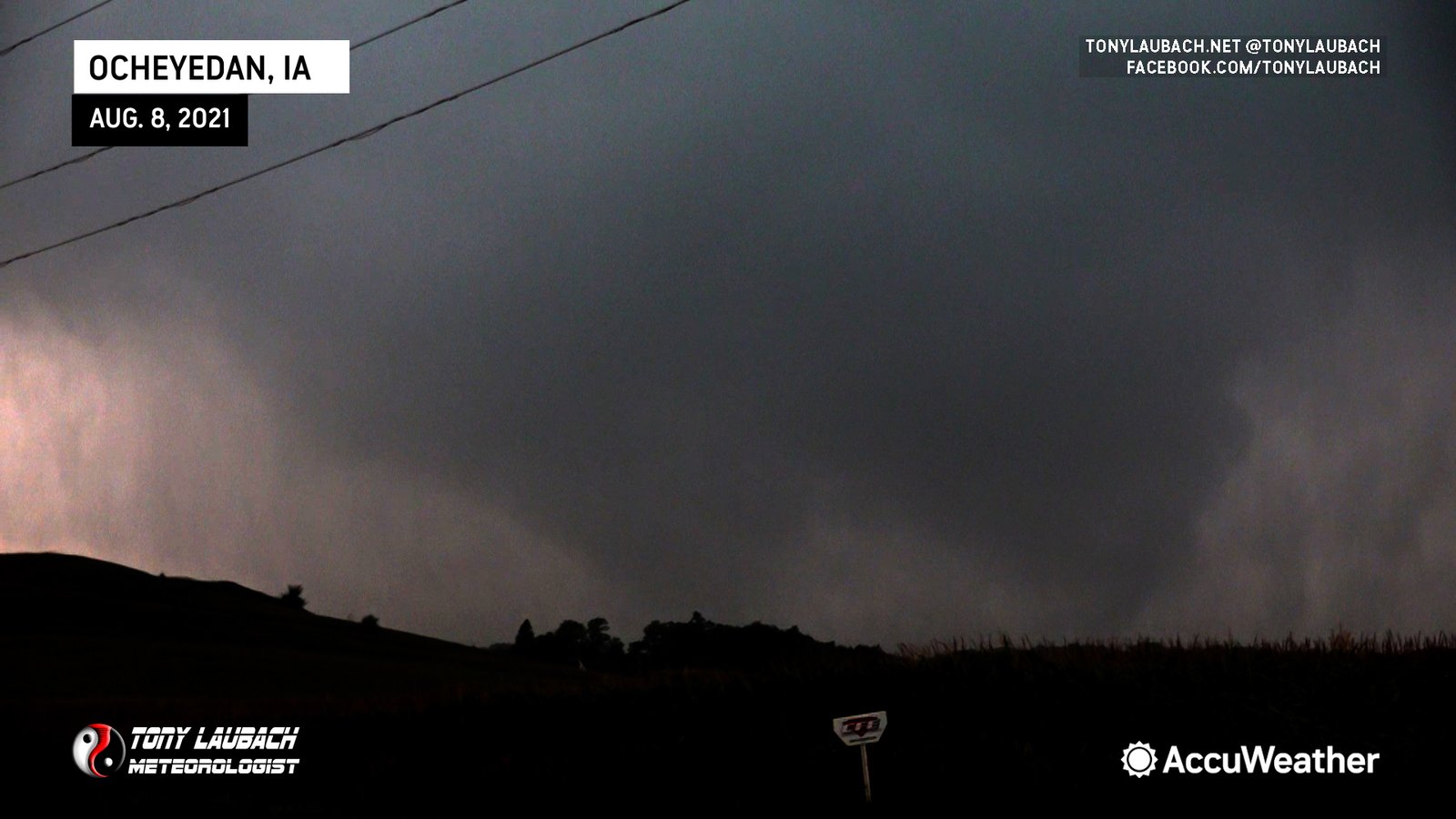
Chase Log: August 8, 2021
Northwest Iowa (544 miles)
After over two decades of a brutal Iowa jinx, I finally saw my first legit tornado in the state, rolling right up a weak EF-0 tornado on the south side of Ocheyedan, Iowa.
• TORNADOES: 1
• MAX HAIL: None
• FLOODING: Observed
• Lightning Imagery: Not Captured
Full Write-Up
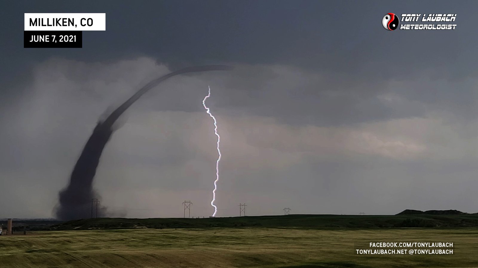
Chase Log: June 7, 2021
Northern Colorado (7 miles)
On a day where it was nearly Meteorologically impossible, an 11,000-foot tall landspout touched down near my home less than two hours after we closed on the house. My wife spotted it first!
• TORNADOES: 1
• MAX HAIL: None
• FLOODING: Observed
• Lightning Imagery: Not Captured
Full Write-Up
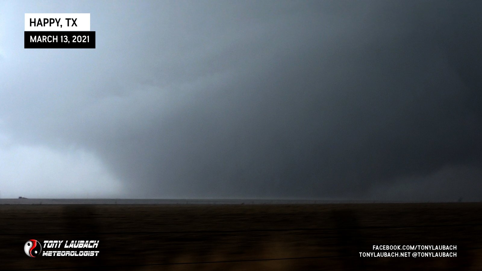
Chase Log: March 13, 2021
Texas Panhandle (877 miles)
A very long day between weathermanning shifts landed me my biggest ever March tornado near Happy, Texas; a 1000-yard wide EF-2 wedge!
• TORNADOES: 2
• MAX HAIL: 1.00"
• FLOODING: Observed
• Lightning Imagery: Not Captured
Full Write-Up
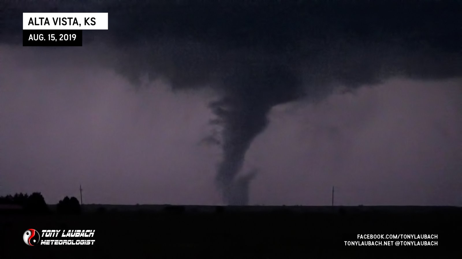
Chase Log: August 15, 2019
Northeast Kansas (417 miles)
A late season chase outside the KAKE viewing area yielded a couple nice early evening tornadoes and a few good lightning photos to round out the summer season.
• TORNADOES: 2
• MAX HAIL: None
• FLOODING: Observed
• Lightning Imagery: Not Captured
Full Write-Up

Chase Log: May 26, 2019
Eastern CO/Southwest KS (690 miles)
I was literally the only person on the planet to see this one tornado and it was not long after EVERY OTHER CHASER had cleared the area.
• TORNADOES: 1
• MAX HAIL: None
• FLOODING: Observed
• Lightning Imagery: Not Captured
Full Write-Up
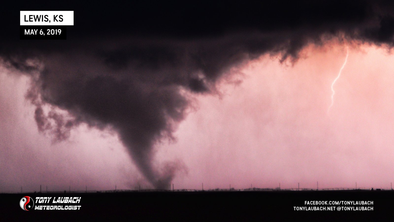
Chase Log: May 6, 2019
Central Kansas (424 miles)
After literally the most beautiful supercell/lightning photos I had ever shot came my best ever nighttime tornado photo on a chase that was full of wall-hangers! Easily my favorite chase of 2019!
• TORNADOES: 1
• MAX HAIL: None
• FLOODING: Not Observed
• Lightning Imagery: Not Captured
Full Write-Up

Chase Log: May 5, 2019
Central Kansas (197 miles)
Intercepted a rain-wrapped tornado near Alden, Kansas and tracked the storm to literally my house and got clobbered with golfball sized hail.
• TORNADOES: 1
• MAX HAIL: 1.75"
• FLOODING: Observed
• Lightning Imagery: Not Captured
In Progress
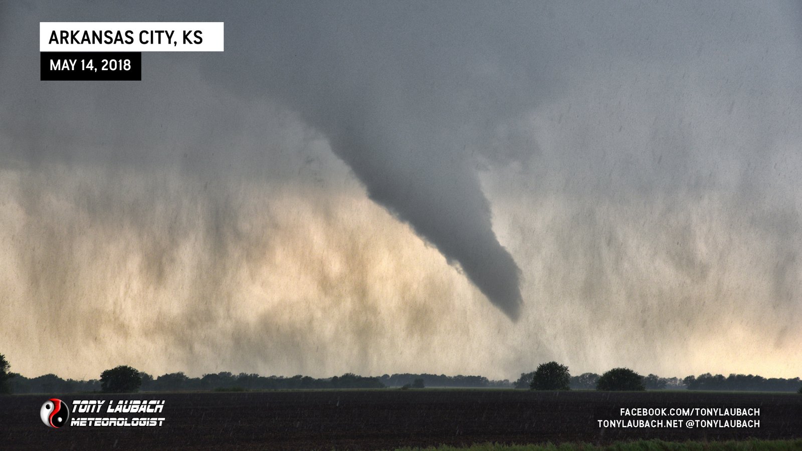
Chase Log: May 14, 2018
Southeast Kansas (140 miles)
My first tornado as a Wichita resident and I put it live on KAKE-TV! But my chase ended abruptly when I was t-boned when a lady ran a stop sign in Arkansas City.
• TORNADOES: 1
• MAX HAIL: 2.00"
• FLOODING: Observed
• Lightning Imagery: Not Captured
In Progress
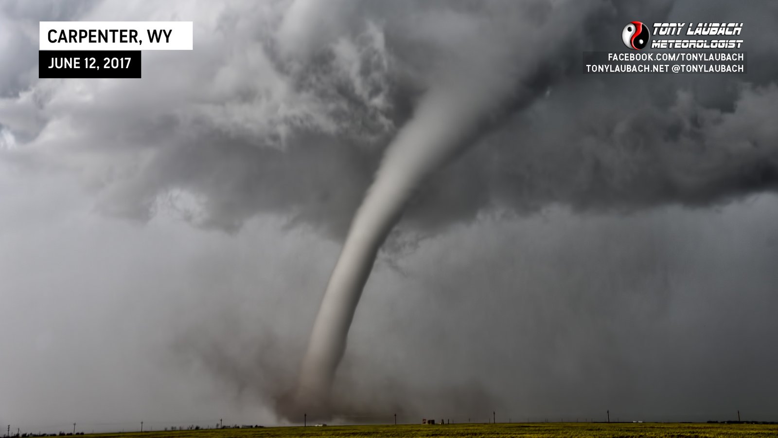
Chase Log: June 12, 2017
CO/WY/NE Tri-State Area (1,373 miles)
One of the most photogenic tornadoes on one of the best chases of my career! Huge hail and amazing tornadoes in Colorado, Wyoming, and Nebraska on a rare Moderate Risk day!
• TORNADOES: 3
• MAX HAIL: 3.00"
• FLOODING: Observed
• Lightning Imagery: Not Captured
Full Write-Up

Chase Log: May 16, 2017
TX Panhandle/Western OK (1,315 miles)
Documented a beautiful supercell and tornado near the TX/OK border and got involved with other tornadic storms in western Oklahoma.
• TORNADOES: 1
• MAX HAIL: 1.75"
• FLOODING: Observed
• Lightning Imagery: Not Captured
In Progress
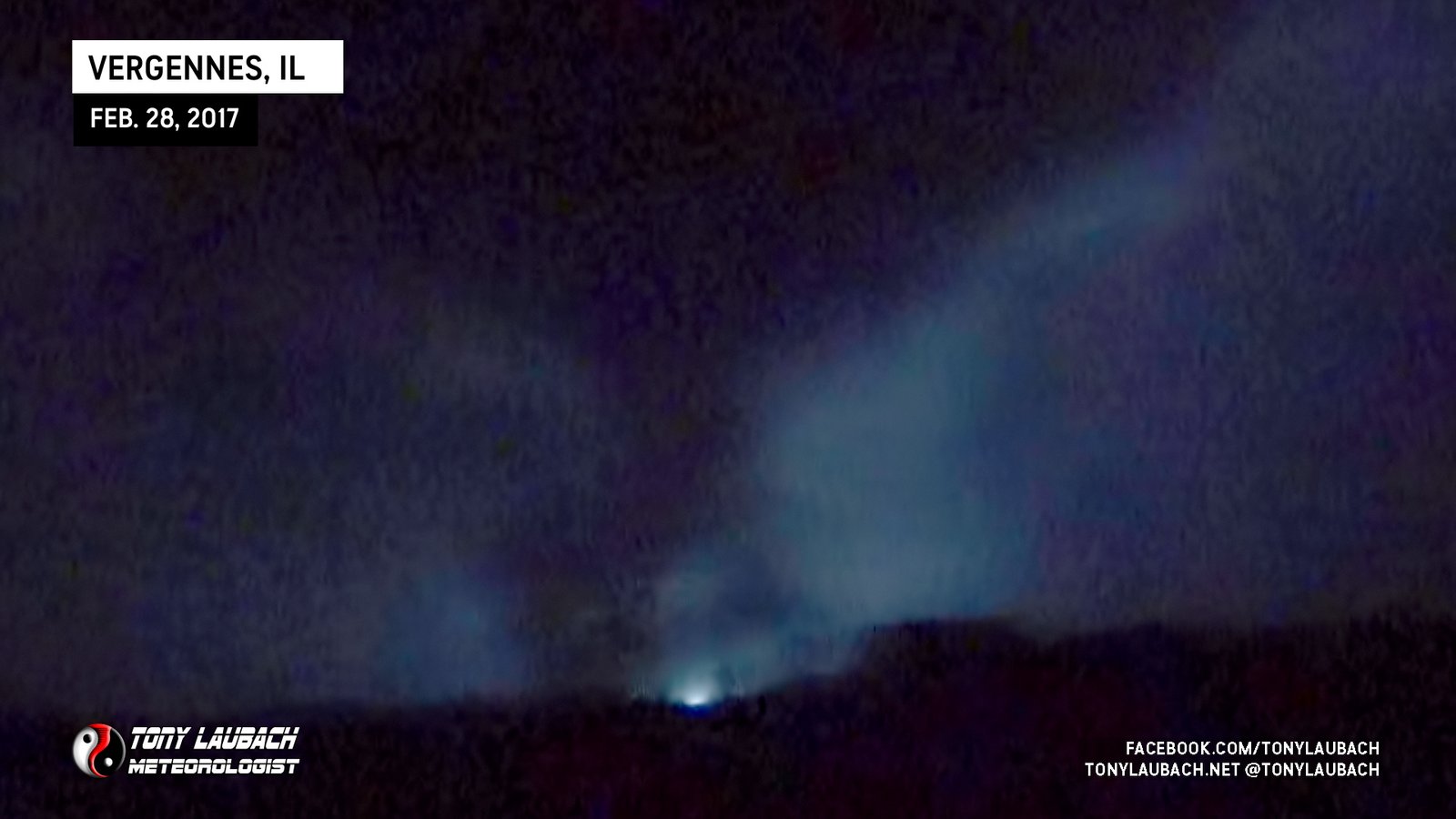
Chase Log: February 28, 2017
Southern Illinois (335 miles)
Easily the biggest tornado chase during my five years in southern Illinois, a close encounter with the nighttime EF-4 long track tornado near Vergennes only a few miles north of my house.
• TORNADOES: 1
• MAX HAIL: 1.25"
• FLOODING: Observed
• Lightning Imagery: Not Captured
In Progress
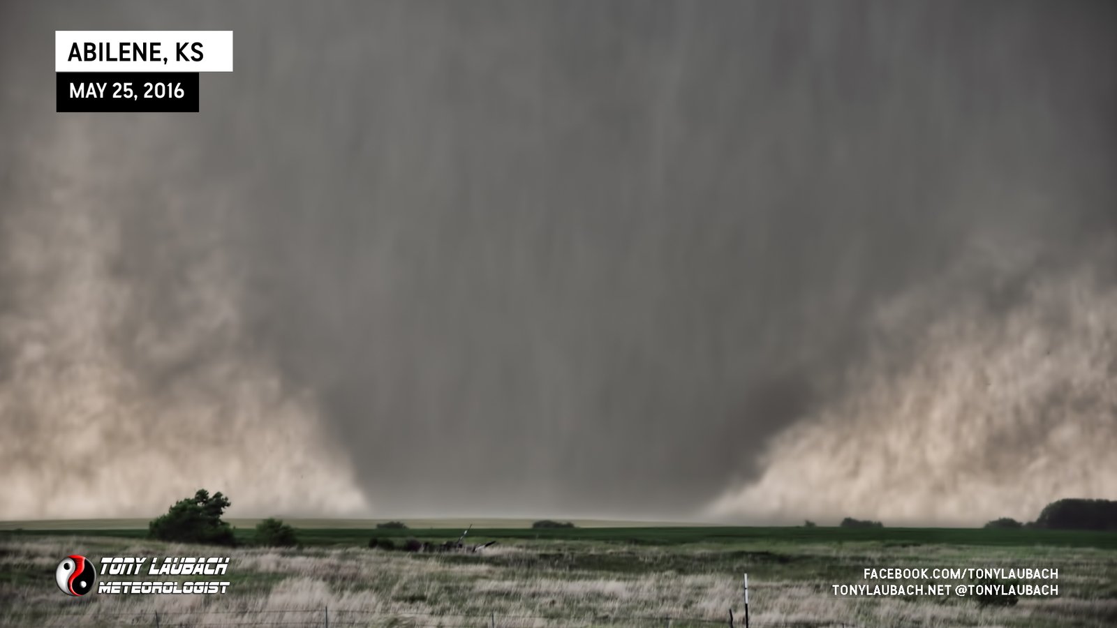
Chase Log: May 25, 2016
Northern Kansas (447 miles)
We started the day with no intention to chase and ended up watching half of the 90-minute life of a monster, ground-shaking EF-4 wedge.
• TORNADOES: 1
• MAX HAIL: None
• FLOODING: Observed
• Lightning Imagery: Not Captured
Full Write-Up
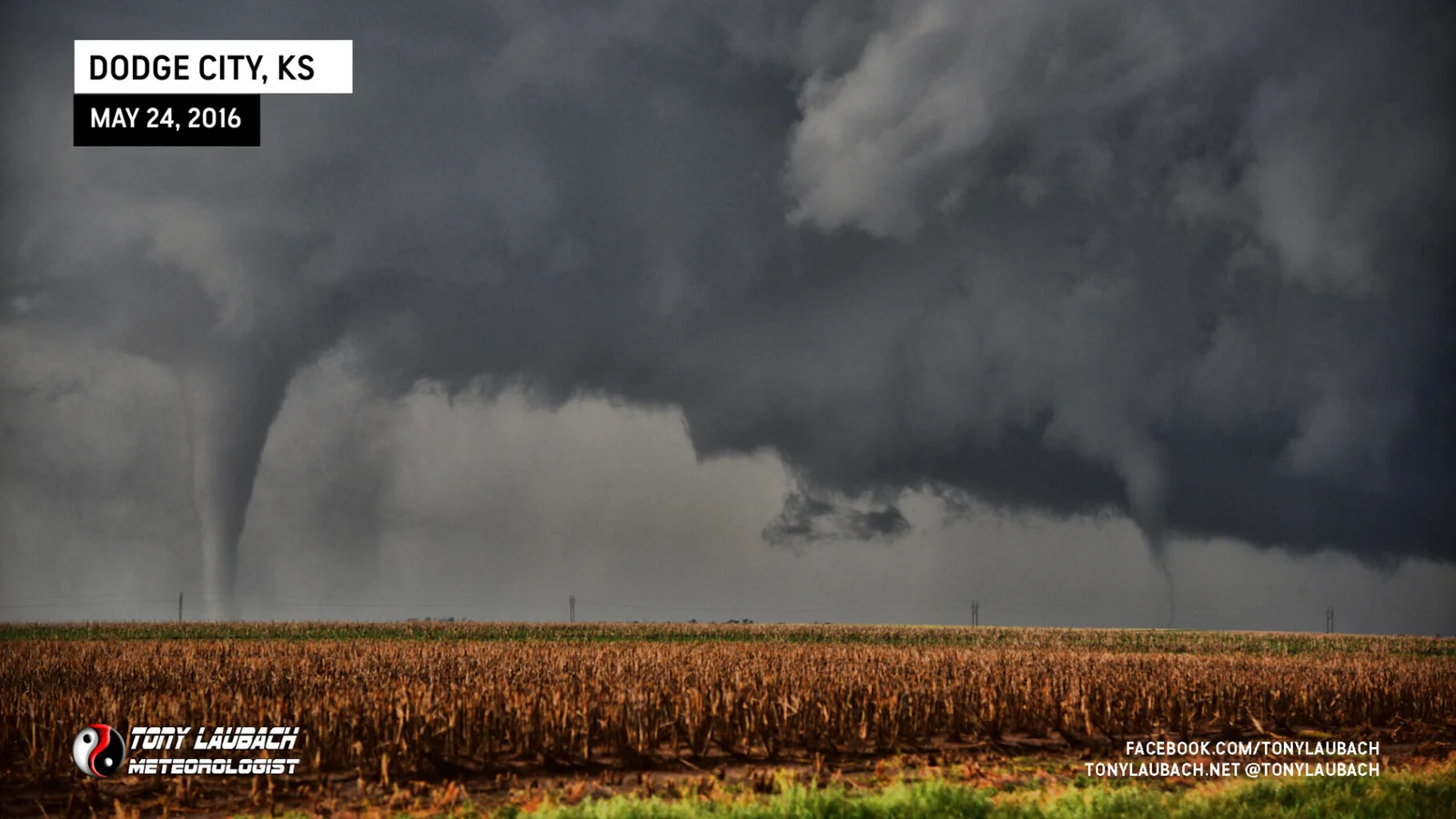
Chase Log: May 24, 2016
Southwest Kansas (281 miles)
An incredible, Top 5 all-time tornado intercept chase that included dozens of tornadoes around the Dodge City area in southwest Kansas. Also included my 300th career tornado.
• TORNADOES: 12
• MAX HAIL: 1.00"
• FLOODING: Observed
• Lightning Imagery: Not Captured
Full Write-Up
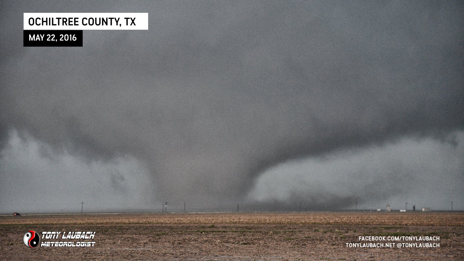
Chase Log: May 22, 2016
Texas Panhandle (381 miles)
Patience paid off in a big way as a series of picturesque tornadoes plopped down after multiple storm mergers southeast of Spearman, Texas.
• TORNADOES: 5
• MAX HAIL: 1.00"
• FLOODING: Observed
• Lightning Imagery: Not Captured
Full Write-Up
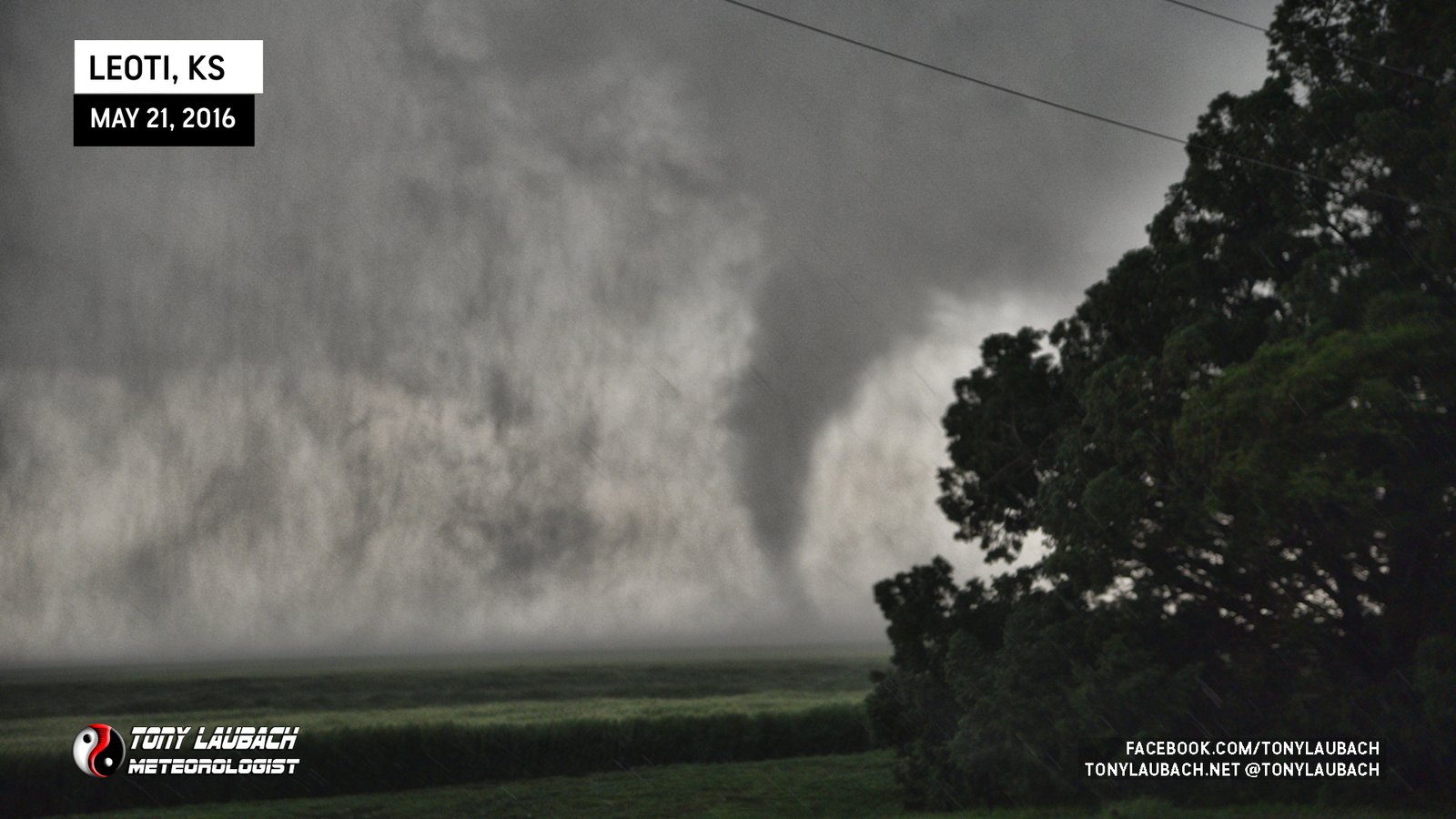
Chase Log: May 21, 2016
Western Kansas (402 miles)
Two tornadoes on a CRAZY beautiful supercell near Leoti, Kansas kicked off one of the most prolific tornado weeks in recent chase memory.
• TORNADOES: 2
• MAX HAIL: 2.00"
• FLOODING: Observed
• Lightning Imagery: Not Captured
Full Write-Up
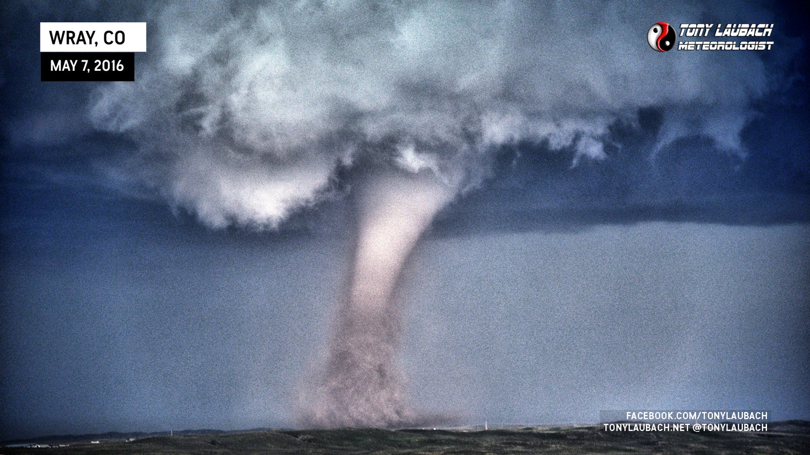
Chase Log: May 7, 2016
Northeast Colorado (406 miles)
Incredible Colorado tornado intercepts, including yards from a large, dusty landspout followed up by an incredibly photogenic EF-2 north of the town of Wray.
• TORNADOES: 2
• MAX HAIL: 1.25"
• FLOODING: Observed
• Lightning Imagery: Not Captured
Full Write-Up
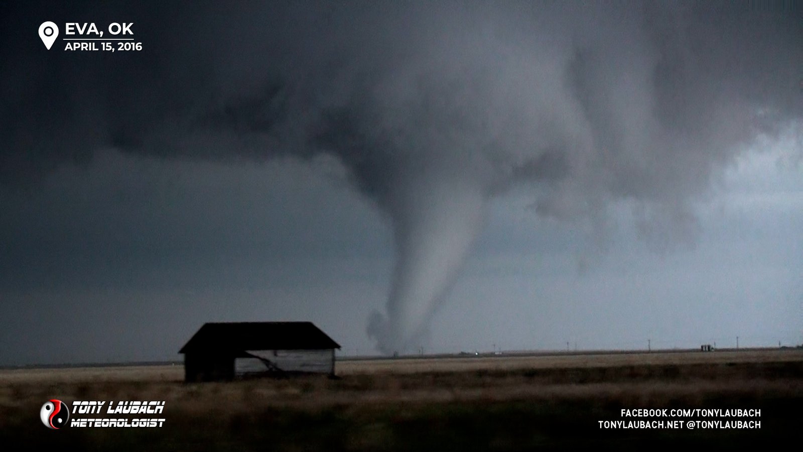
Chase Log: April 15, 2016
TX/OK Panhandles (0 miles)
Caught a couple close tornadoes on some slick, muddy roads in the Oklahoma Panhandle and got pummeled by big hail down in Dalhart, Texas.
• TORNADOES: 2
• MAX HAIL: 2.00"
• FLOODING: Observed
• Lightning Imagery: Not Captured
Full Write-Up
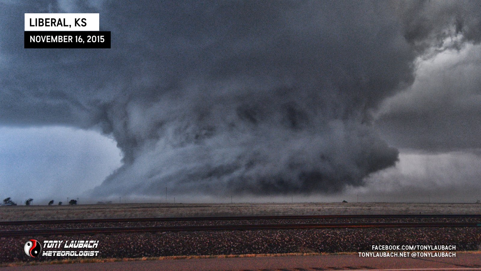
Chase Log: November 16, 2015
Southwest Kansas (1,774 miles)
Easily my best ever off-season chase on a historic outbreak of tornadoes where I tracked an incredible supercell across southwest Kansas into the night.
• TORNADOES: 3
• MAX HAIL: 1.75"
• FLOODING: Observed
• Lightning Imagery: Not Captured
In Progress
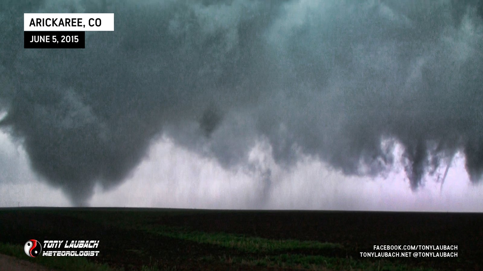
Chase Log: June 5, 2015
Eastern Colorado (480 miles)
A rather surprising day in eastern Colorado 24 hours after missing Simla where one of my good friends saw her very first tornadoes!
• TORNADOES: 5
• MAX HAIL: 1.00"
• FLOODING: Observed
• Lightning Imagery: Not Captured
In Progress
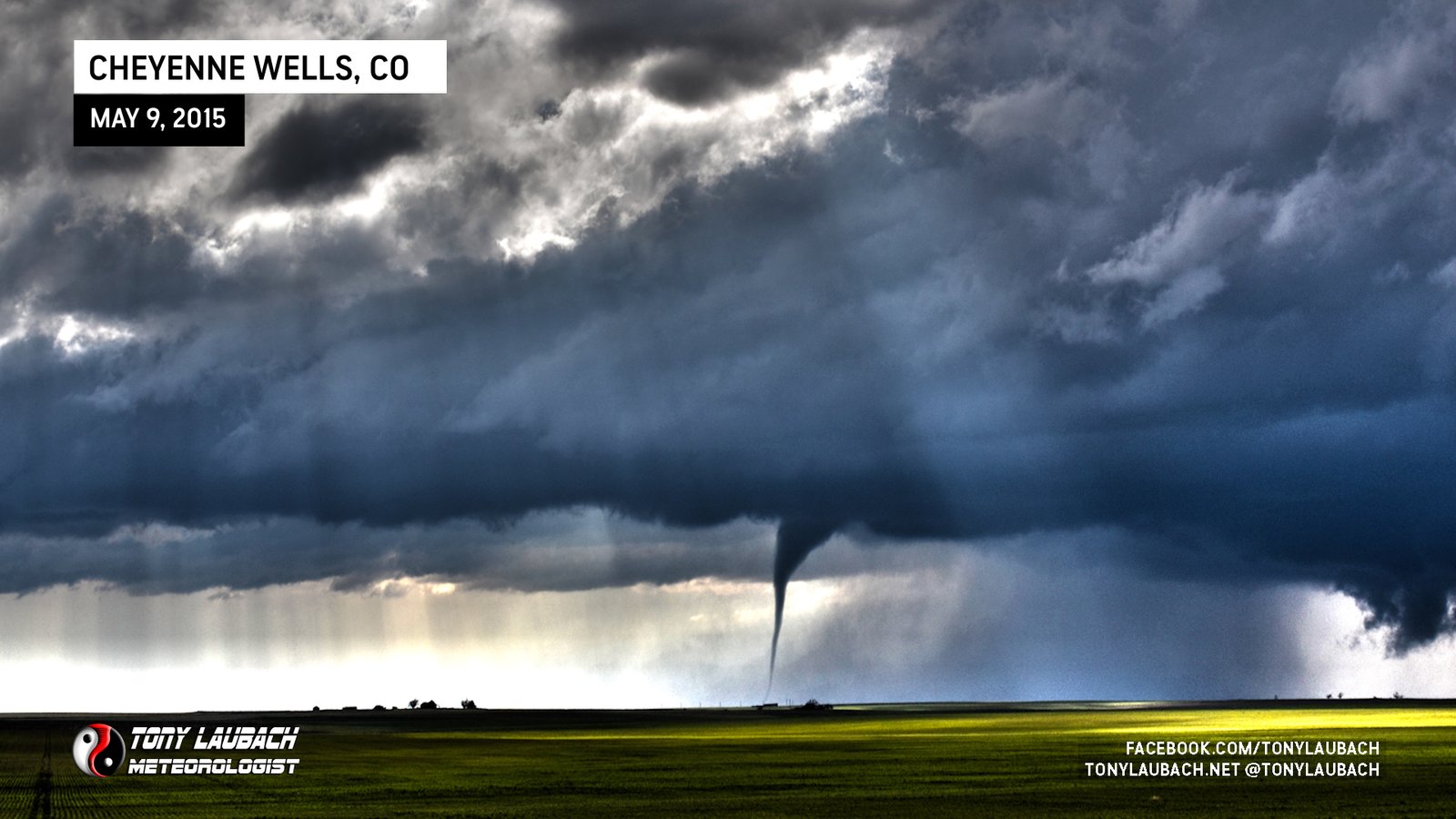
Chase Log: May 9, 2015
Eastern Colorado (690 miles)
Easily my best Colorado tornado chase day to date! We documented four tornadoes, including one from nearly 50 miles away in Kansas.
• TORNADOES: 4
• MAX HAIL: 1.25"
• FLOODING: Observed
• Lightning Imagery: Not Captured
In Progress
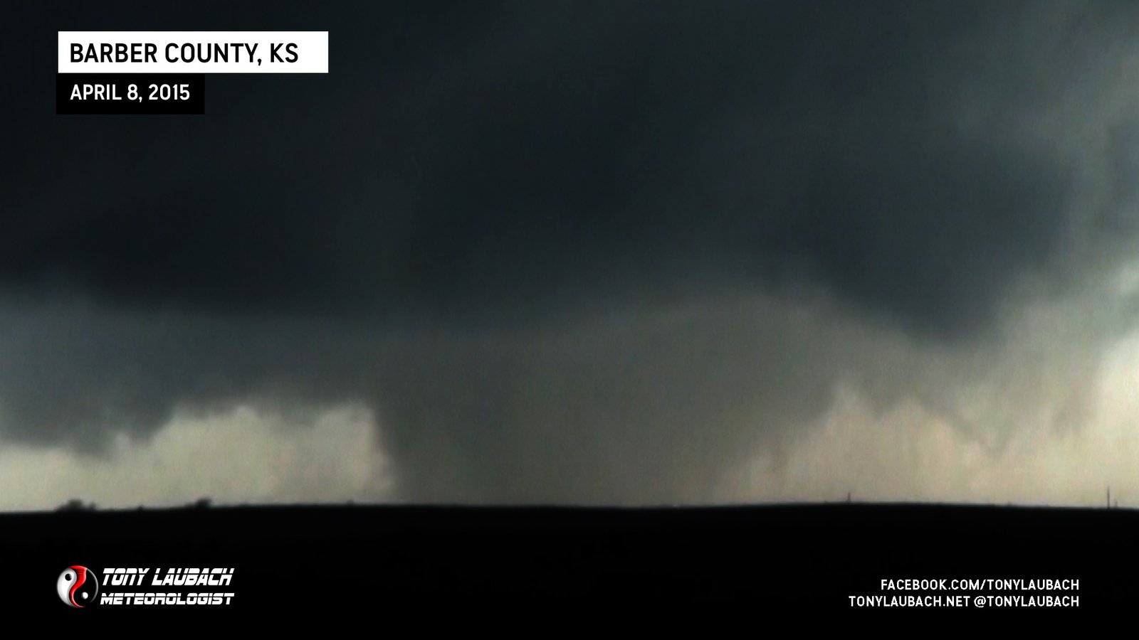
Chase Log: April 8, 2015
Southern Kansas (1,010 miles)
Documented the world's shortest-duration wedge tornado southwest of Medicine Lodge before getting cored in golfball-sized hail.
• TORNADOES: 1
• MAX HAIL: 1.75"
• FLOODING: Observed
• Lightning Imagery: Not Captured
Full Write-Up
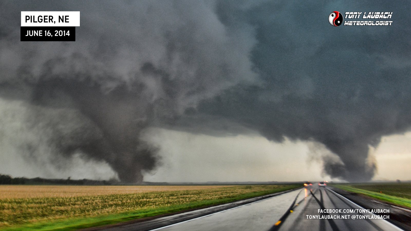
Chase Log: June 16, 2014
Northeast Nebraska (987 miles)
A once-in-a-generation tornado event that included the infamous Pilger twin EF-4 tornadoes. A total of FOUR EF-4 tornadoes touched down within a few hours of each other in northeast Nebraska.
• TORNADOES: 5
• MAX HAIL: None
• FLOODING: Observed
• Lightning Imagery: Not Captured
Full Write-Up

Chase Log: May 10, 2014
Central Missouri (649 miles)
A trip across Missouri yielded the intercept of a massive rain-wrapped wedge tornado outside the town of Marshall.
• TORNADOES: 1
• MAX HAIL: None
• FLOODING: Observed
• Lightning Imagery: Not Captured
In Progress
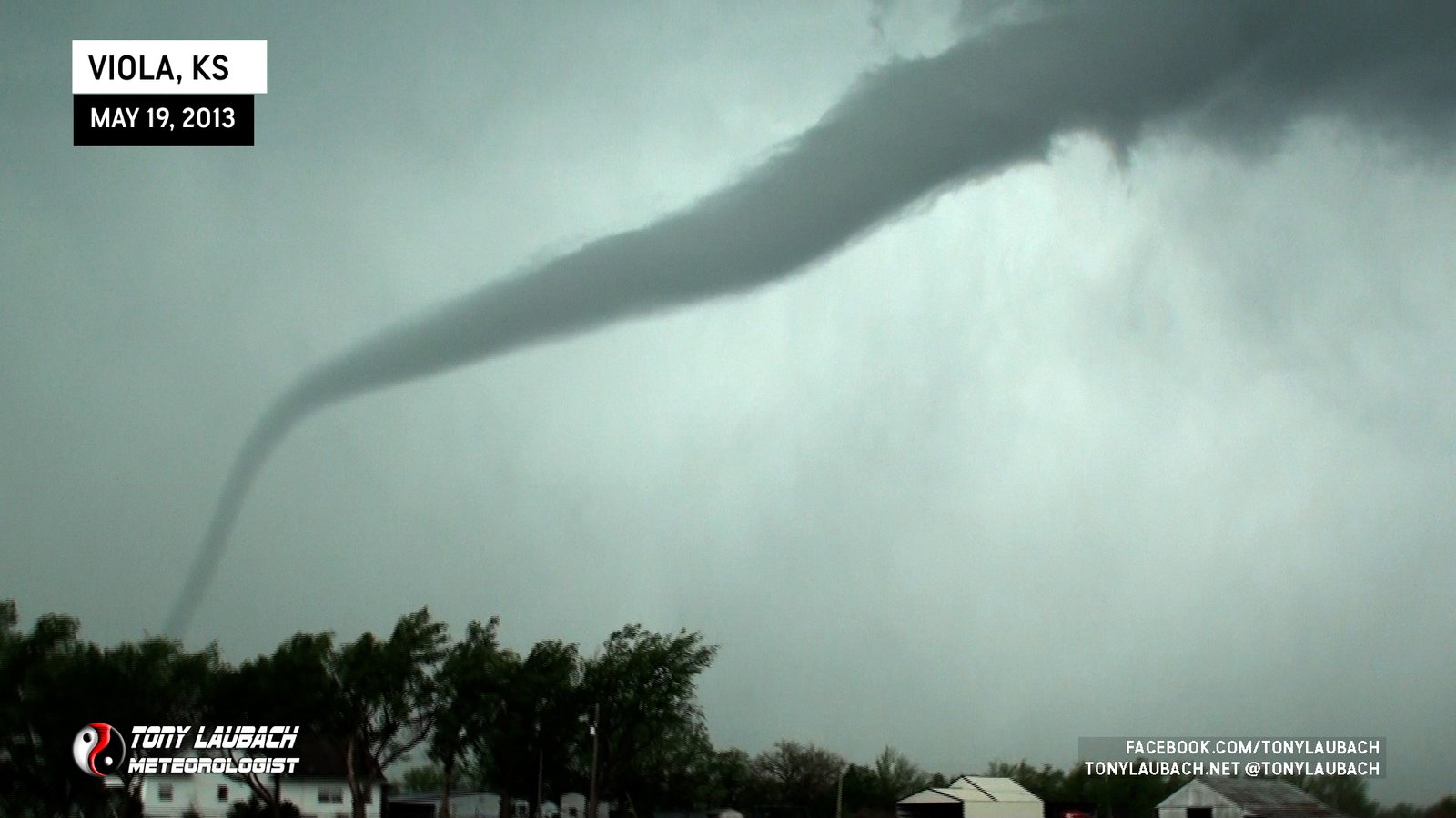
Chase Log: May 19, 2013
Southern Kansas (312 miles)
I tracked multiple tornadoes dangerously close to Wichita on a high-impact day in southern Kansas, including a rather pretty elephant trunk near Viola.
• TORNADOES: 4
• MAX HAIL: N/A
• FLOODING: Observed
• Lightning Imagery: Not Captured
In Progress

Chase Log: May 18, 2013
Central Kansas (1,296 miles)
A day I saved after missing the Rozel tornado, I managed to get down in time to see a pink tornado at sunset near Sanford, KS.
• TORNADOES: 2
• MAX HAIL: 1.00"
• FLOODING: Observed
• Lightning Imagery: Not Captured
In Progress

Chase Log: April 14, 2012
Central Kansas (989 miles)
One of my top Kansas chases ever with several close, incredibly photogenic tornadoes across central Kansas on this historic High Risk day!
• TORNADOES: 7
• MAX HAIL: 1.25"
• FLOODING: Observed
• Lightning Imagery: Not Captured
Full Write-Up
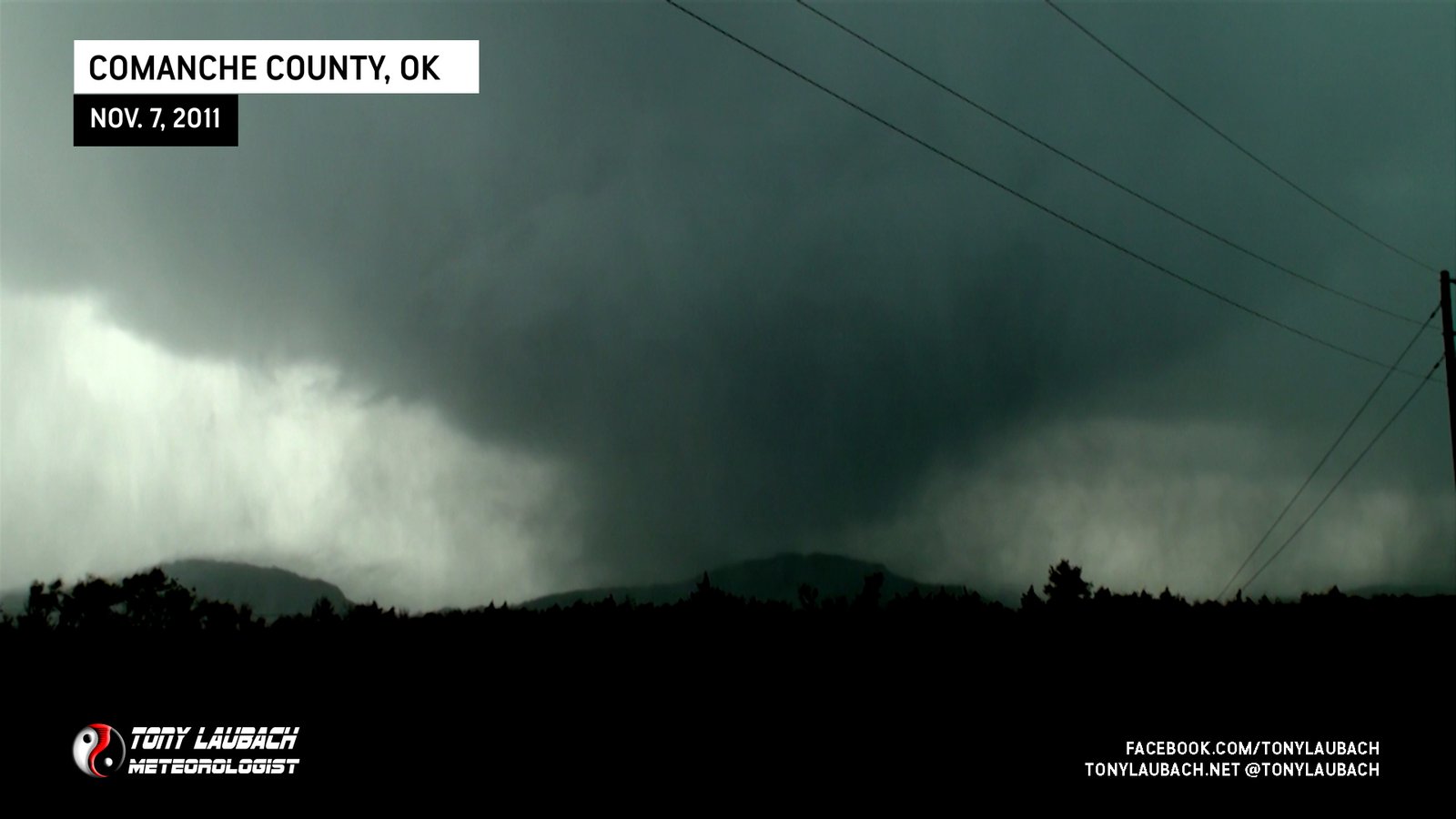
Chase Log: November 7, 2011
Southwest Oklahoma (1,525 miles)
Quakenado, literally all that needs to be said for this crazy Oklahoma day where I documented four tornadoes. Oh yeah, there was an earthquake, too! Just another day in Oklahoma.
• TORNADOES: 4
• MAX HAIL: 1.25"
• FLOODING: Observed
• Lightning Imagery: Not Captured
In Progress

Chase Log: June 20, 2011
Central Nebraska (742 miles)
Our finale chase with Discovery Channel yielded one of the most photogenic tornadoes of the year and the afterparty that will live on forever!
• TORNADOES: 3
• MAX HAIL: N/A
• FLOODING: Observed
• Lightning Imagery: Not Captured
In Progress
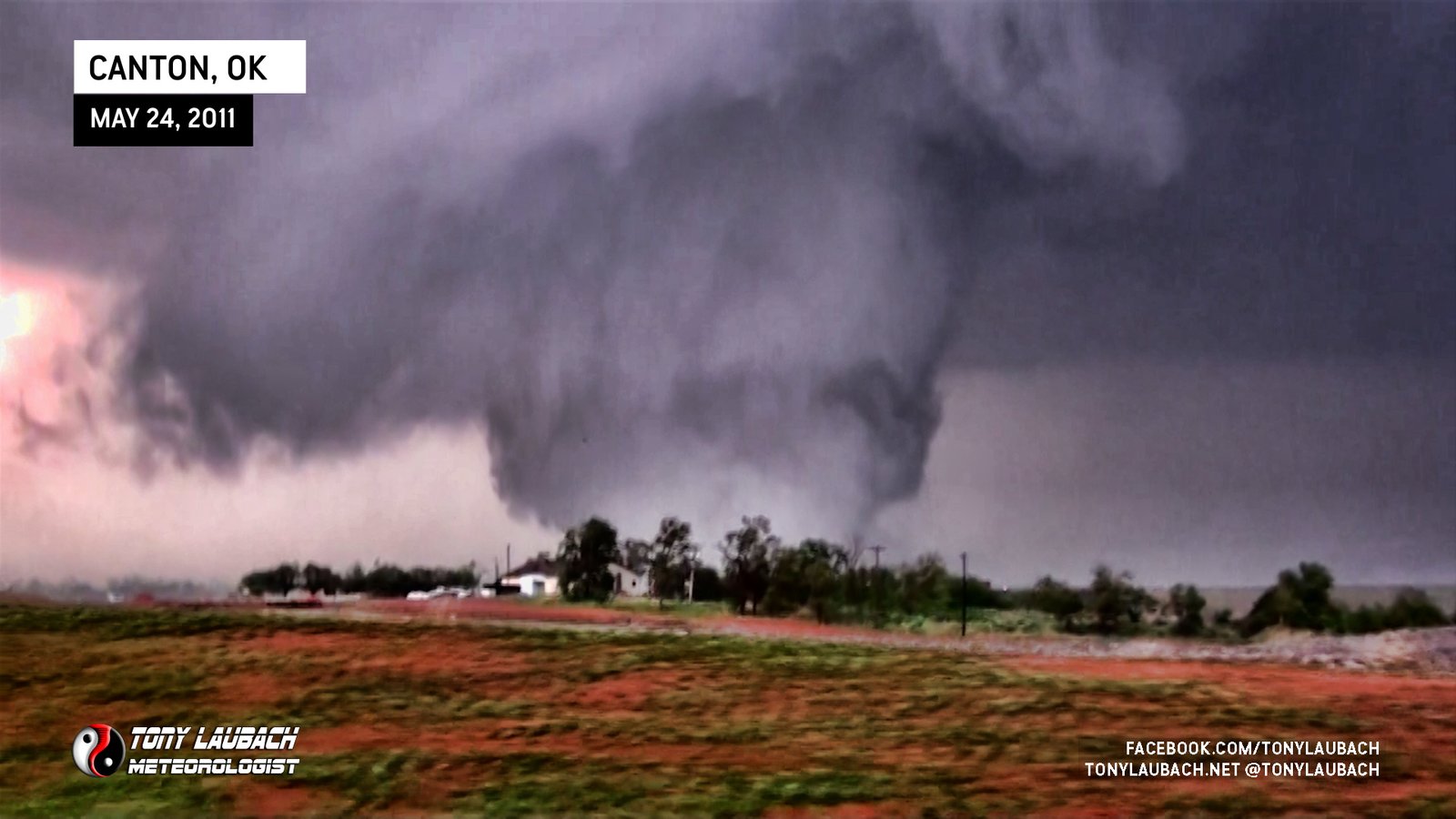
Chase Log: May 24, 2011
Central Oklahoma (403 miles)
A historic tornado outbreak across the Central Plains as our TWISTEX crew documented several large, violent tornadoes around Canton Lake, including a large EF-3 and my 200th career tornado near Fairview.
• TORNADOES: 2
• MAX HAIL: 1.00"
• FLOODING: Observed
• Lightning Imagery: Not Captured
Full Write-Up

Chase Log: April 27, 2011
Eastern MS/Western AL (2,000 miles)
It was one of the biggest tornado outbreaks in history, and we barely observed four of the countless tornadoes on this insane high risk event.
• TORNADOES: 4
• MAX HAIL: None
• FLOODING: Observed
• Lightning Imagery: Not Captured
In Progress
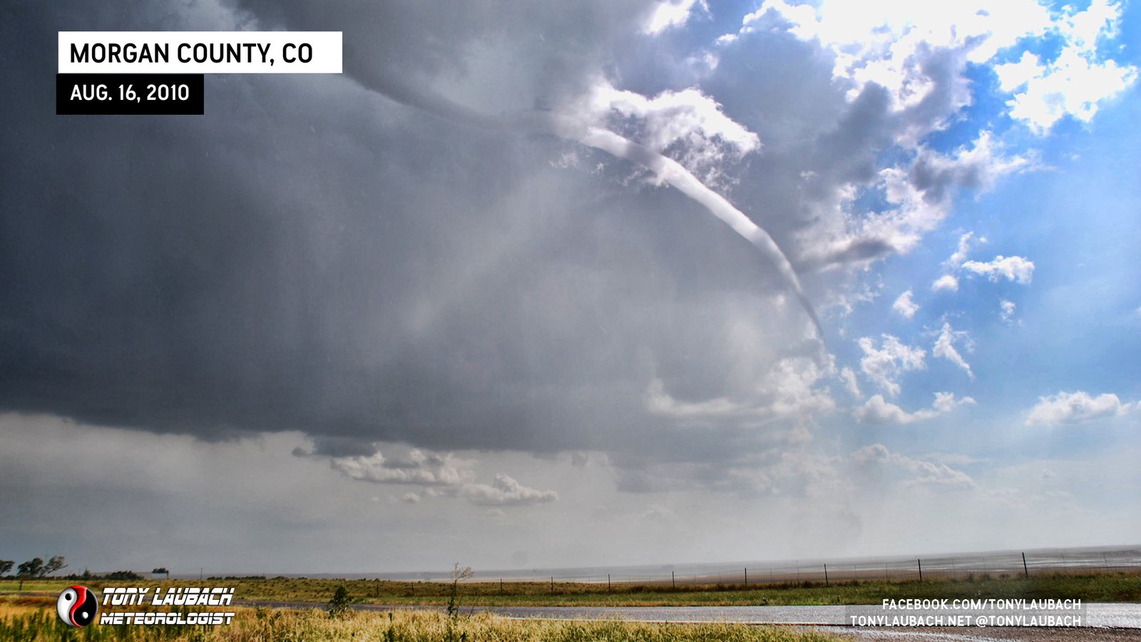
Chase Log: August 16, 2010
Northeast Colorado (260 miles)
It was eight years in the making, but I finally destroyed the Colorado curse that has plagued me for years! After many Colorado misses, I finally nabbed some beautiful Colorado tornadoes!
• TORNADOES: 3
• MAX HAIL: 1.00"
• FLOODING: Observed
• Lightning Imagery: Not Captured
Full Write-Up

Chase Log: May 24, 2010
Northern SD/Southern ND (891 miles)
This was THE weirdest, most unusual tornado chase day of my entire career! TWISTEX crews intercepted multiple tornadoes in the Dakotas on a cool, foggy, dreary warm-front setup.
• TORNADOES: 9
• MAX HAIL: None
• FLOODING: Observed
• Lightning Imagery: Not Captured
In Progress

Chase Log: May 22, 2010
Northeast South Dakota (546 miles)
Easily one of the best TWISTEX chase days, including multiple deployments on the Bowdle EF-4 monster! Six other tornadoes documented and deployed on as well!
• TORNADOES: 7
• MAX HAIL: 1.00"
• FLOODING: Observed
• Lightning Imagery: Not Captured
Full Write-Up
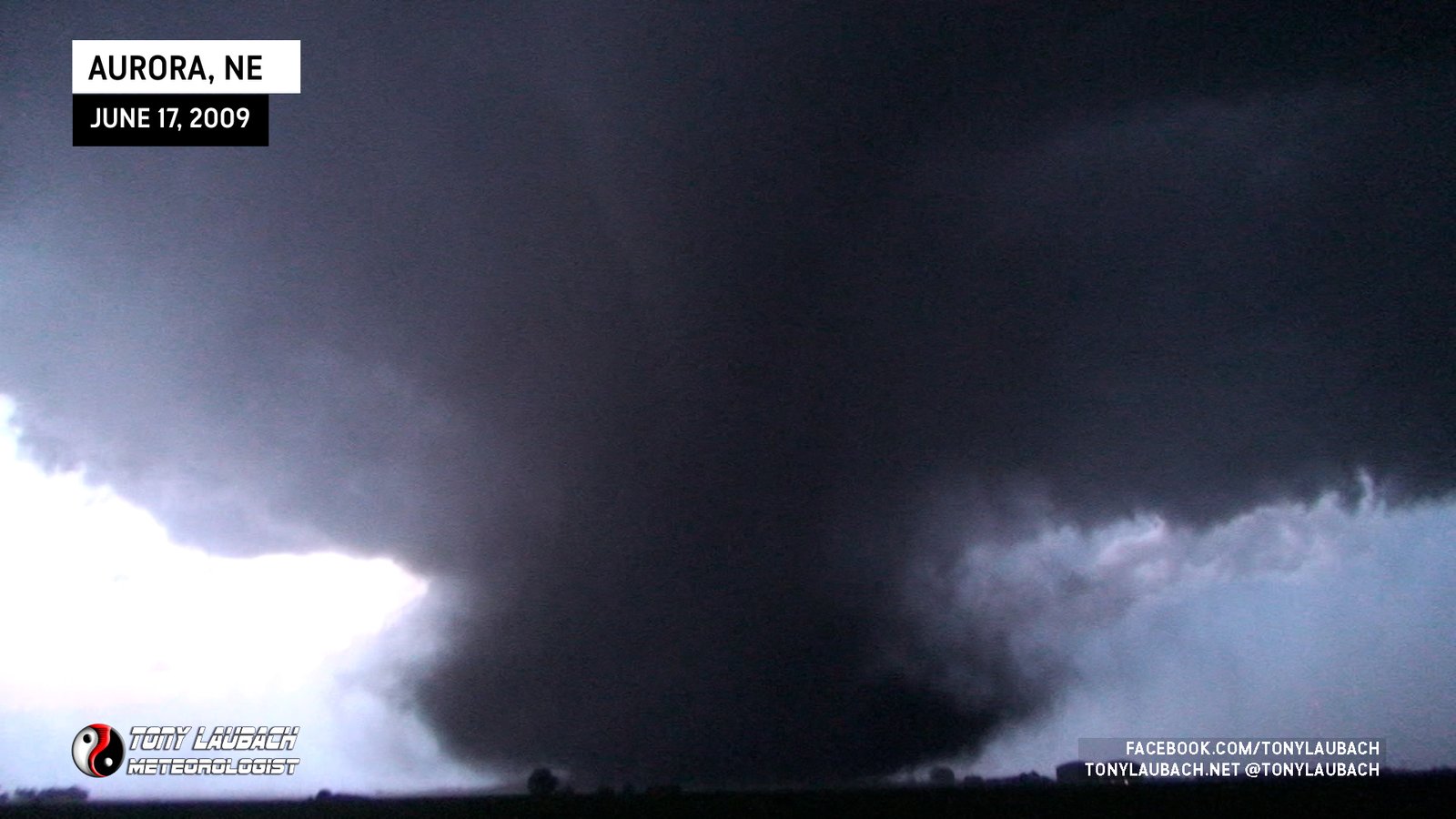
Chase Log: June 17, 2009
Central Nebraska (645 miles)
This was the best TWISTEX tornado deployment to date! In all, we documented nine tornadoes, including the large, dusty headliner EF-2 near Aurora, Nebraska.
• TORNADOES: 9
• MAX HAIL: N/A
• FLOODING: Observed
• Lightning Imagery: Not Captured
Full Write-Up
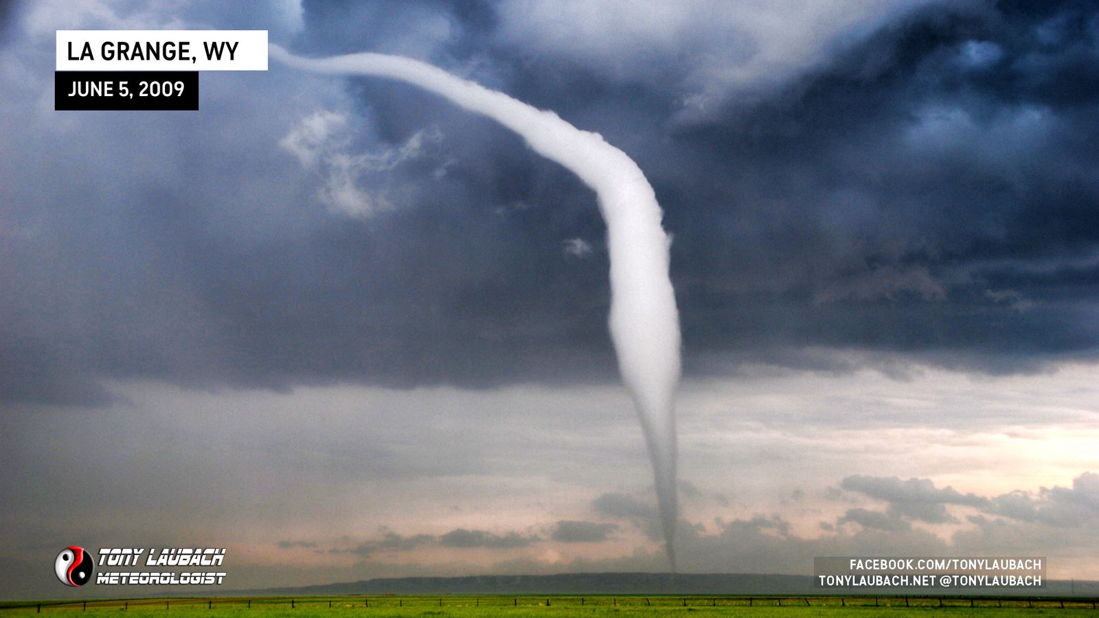
Chase Log: June 5, 2009
Eastern Wyoming (511 miles)
TWISTEX contributed to one of the most documented and researched tornadoes in history on a beautiful long-lived tornado in eastern Wyoming.
• TORNADOES: 1
• MAX HAIL: 3.00"
• FLOODING: Observed
• Lightning Imagery: Not Captured
In Progress
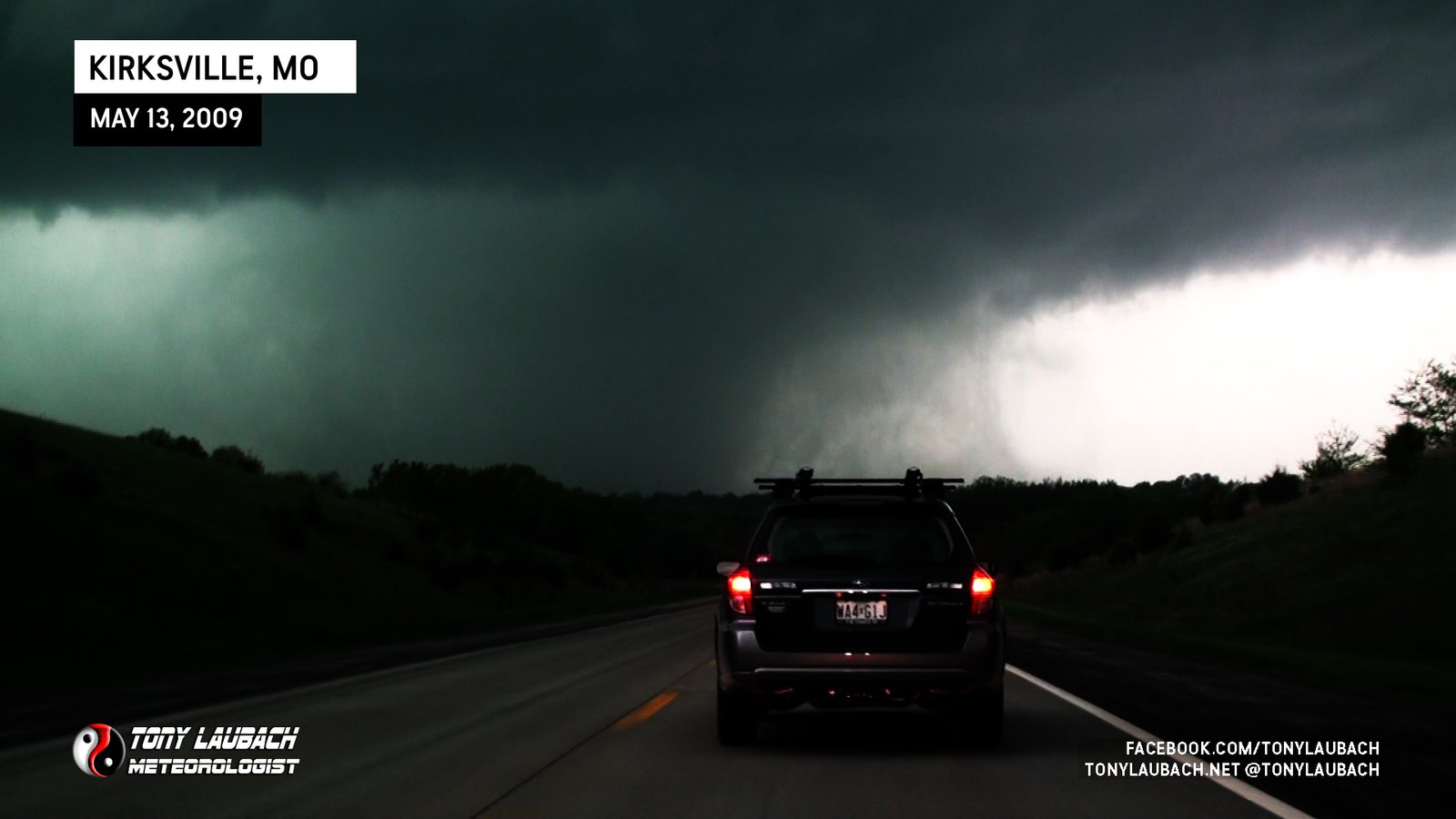
Chase Log: May 13, 2009
Northern Missouri (1,108 miles)
Less than 24 hours after my last Meteorology final, I documented my first tornado as a degreed Meteorologist and the TWISTEX team celebrated with me dressing in my #81 jerseys.
• TORNADOES: 2
• MAX HAIL: N/A
• FLOODING: Observed
• Lightning Imagery: Not Captured
In Progress
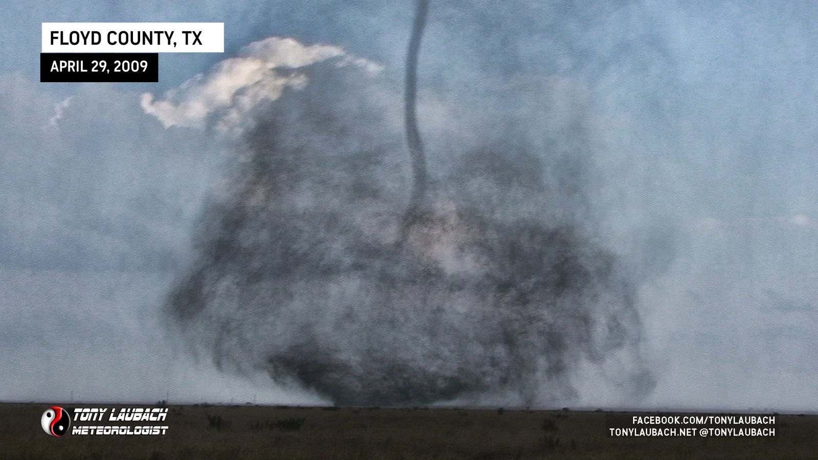
Chase Log: April 29, 2009
Texas Panhandle (1,146 miles)
TWISTEX intercepted multiple tornadoes east of Plainview, Texas and would later get stuck on muddy roads outside Cedar Hill.
• TORNADOES: 4
• MAX HAIL: 1.00"
• FLOODING: Observed
• Lightning Imagery: Not Captured
In Progress
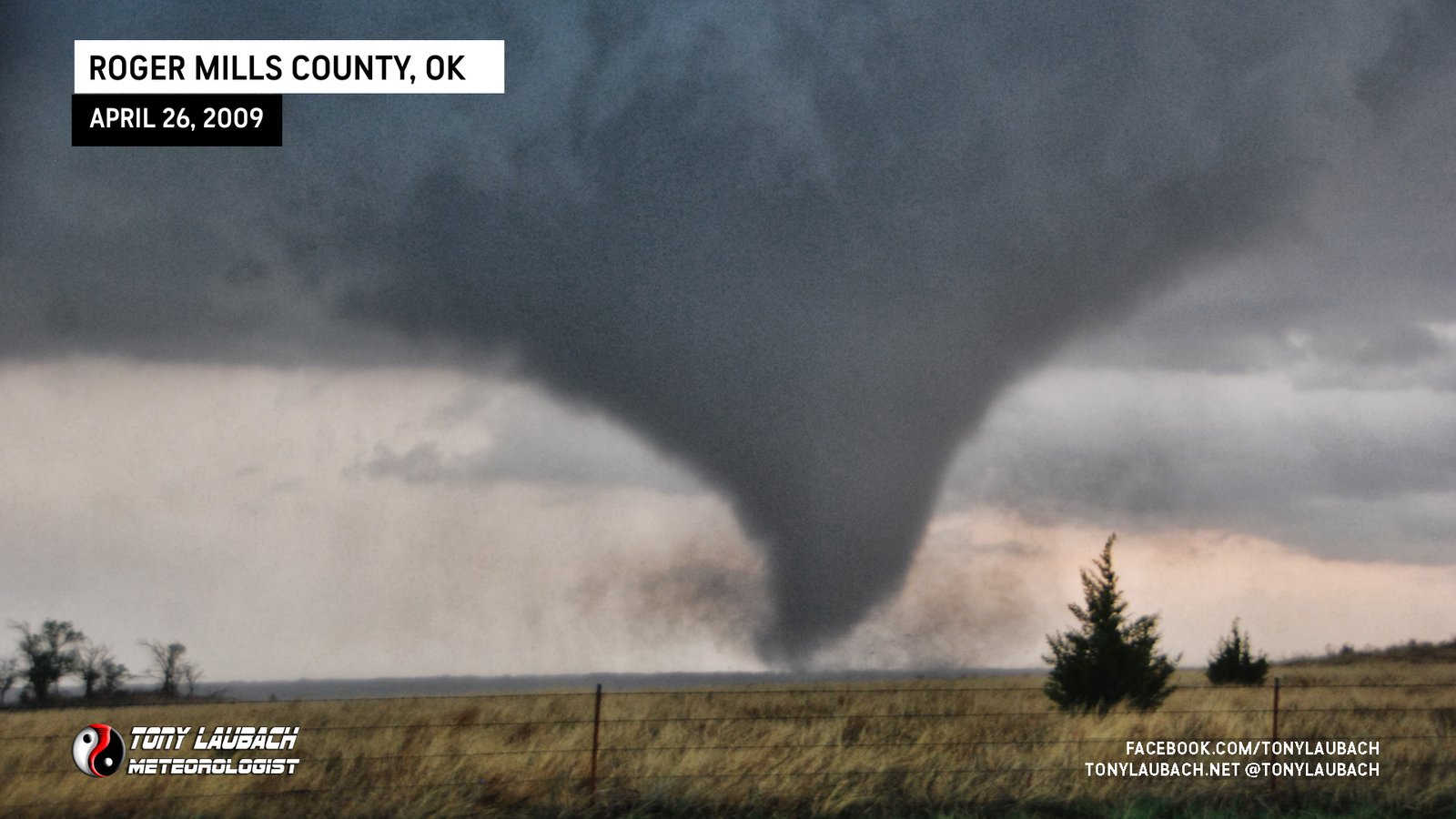
Chase Log: April 26, 2009
Western Oklahoma (1,091 miles)
A high risk in western Oklahoma that yielded only a couple tornadoes which we intercepted with TWISTEX on our second chase of the season.
• TORNADOES: 2
• MAX HAIL: None
• FLOODING: Observed
• Lightning Imagery: Not Captured
In Progress
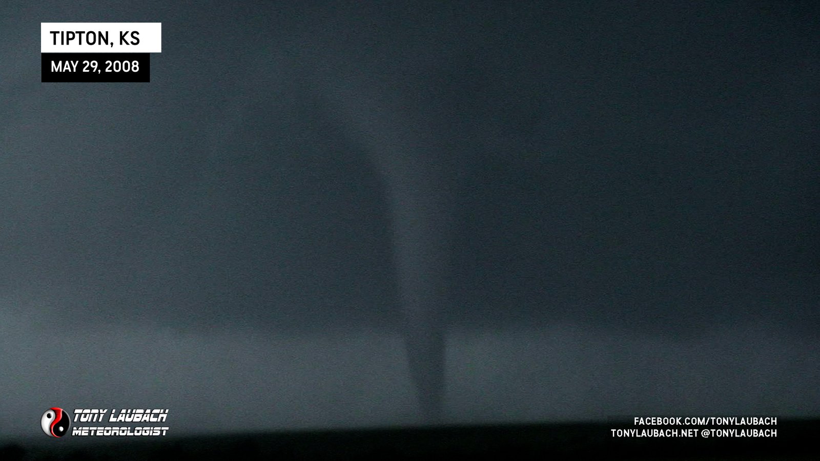
Chase Log: May 29, 2008
Southern NE/Northern KS (1,343 miles)
My first major probe deployment with TWISTEX! Double-digit tornadoes across Nebraska and Kansas including a direct impact after dark after a wild chase of a multi-vortex monster!
• TORNADOES: 16
• MAX HAIL: 2.50"
• FLOODING: Observed
• Lightning Imagery: Not Captured
Full Write-Up
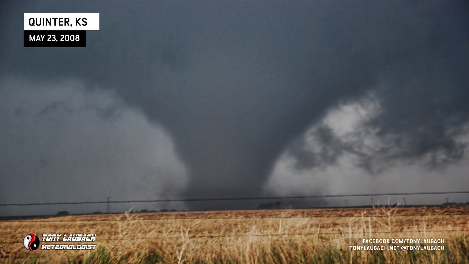
Chase Log: May 23, 2008
Northwest Kansas (275 miles)
Seven tornadoes intercepted by the TWISTEX team, including one that blows a mesonet vehicle into the ditch and knocks down powerlines on another vehicle.
• TORNADOES: 7
• MAX HAIL: 1.75"
• FLOODING: Observed
• Lightning Imagery: Not Captured
Full Write-Up
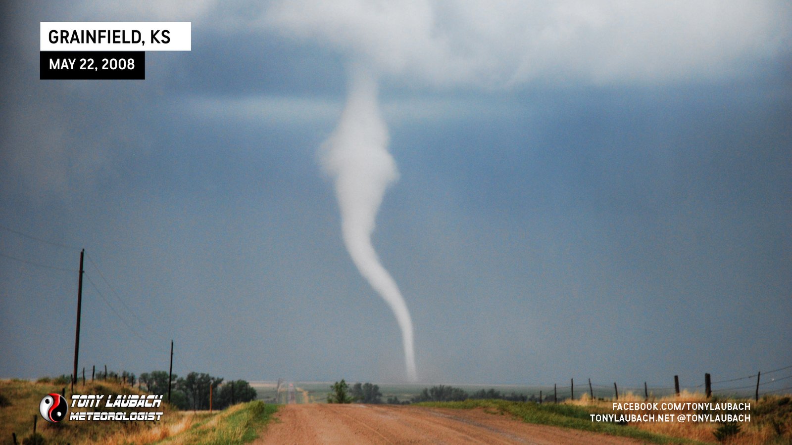
Chase Log: May 22, 2008
Northwest Kansas (486 miles)
While we missed the Windsor, Colorado tornado, northwest Kansas put on a show with several tornadoes intercepted along I-70; including one we watched from a ditch.
• TORNADOES: 5
• MAX HAIL: 2.00"
• FLOODING: Observed
• Lightning Imagery: Not Captured
Full Write-Up
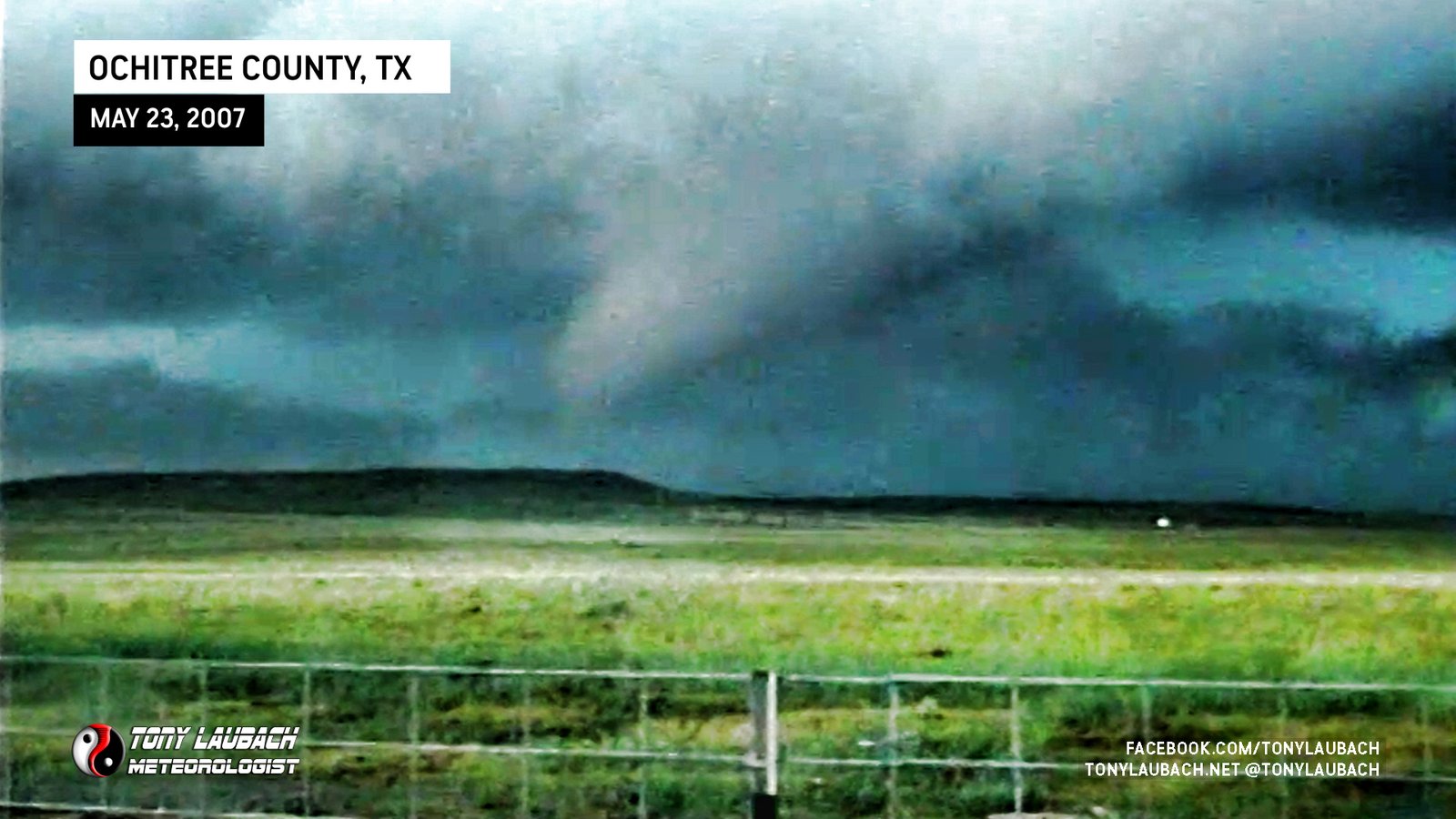
Chase Log: May 23, 2007
Texas Panhandle (899 miles)
TWISTEX team intercepted two tornadoes east of Lake Fryer in Ochiltree County, Texas while trying to gather hail data on an HP storm.
• TORNADOES: 2
• MAX HAIL: 1.00"
• FLOODING: Observed
• Lightning Imagery: Not Captured
Full Write-Up
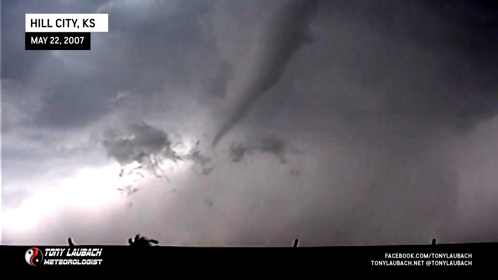
Chase Log: May 22, 2007
Northern Kansas (545 miles)
TWISTEX crews intercepted a tornado southwest of Hill City, Kansas and got into some hail before hijinks at a drive-thru later in the evening.
• TORNADOES: 1
• MAX HAIL: 1.00"
• FLOODING: Observed
• Lightning Imagery: Not Captured
Full Write-Up
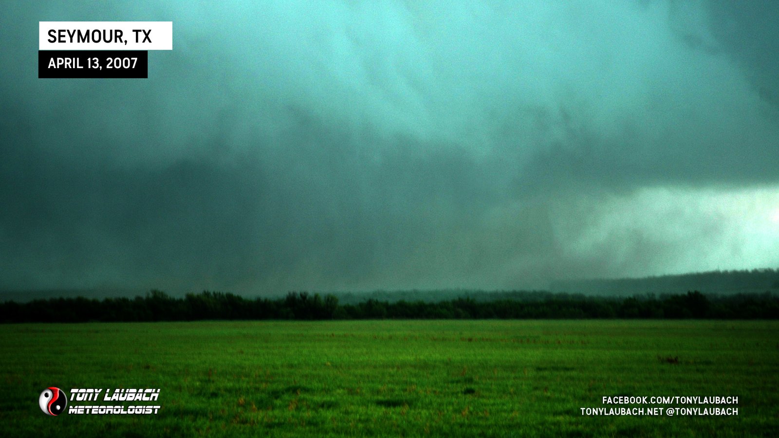
Chase Log: April 13, 2007
Northwest Texas (1,270 miles)
A high risk day that would've busted, except we took the bait on a sucker storm early on and witnessed the biggest, and one of the only tornadoes of the event.
• TORNADOES: 1
• MAX HAIL: 2.50"
• FLOODING: Observed
• Lightning Imagery: Not Captured
Full Write-Up

Chase Log: April 10, 2005
Northwest Kansas (1,186 miles)
My first cold core tornado chase was a massive success as we documented five tornadoes near I-70 in central Kansas.
• TORNADOES: 5
• MAX HAIL: 1.00"
• FLOODING: Observed
• Lightning Imagery: Not Captured
Full Write-Up
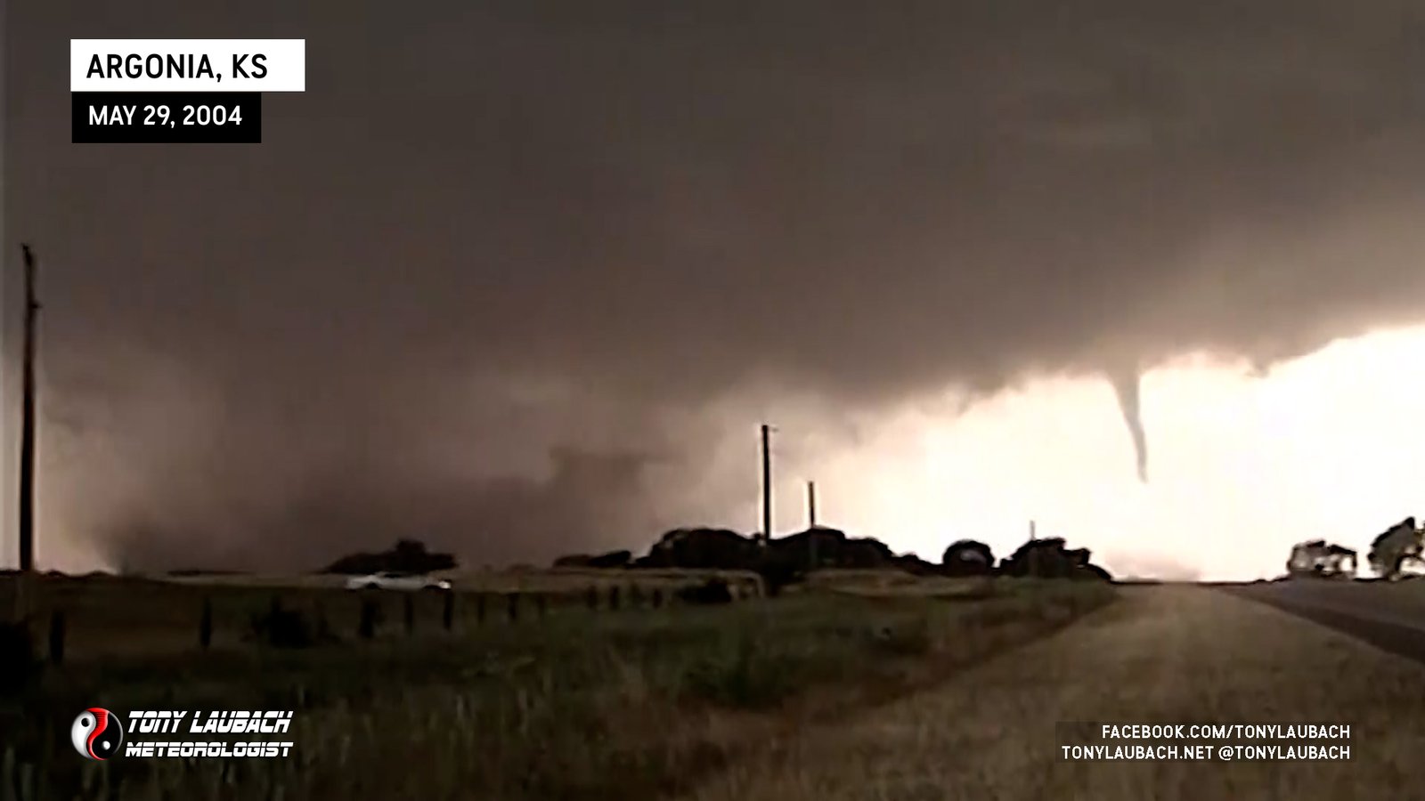
Chase Log: May 29, 2004
Southern Kansas (1,417 miles)
For nearly 20 years, this was my number 1 chase! Over a dozen tornadoes across southern Kansas, including the Conway Springs sequence which included my first ever nationally televised tornado video!
• TORNADOES: 15
• MAX HAIL: 1.00"
• FLOODING: Observed
• Lightning Imagery: Not Captured
Full Write-Up
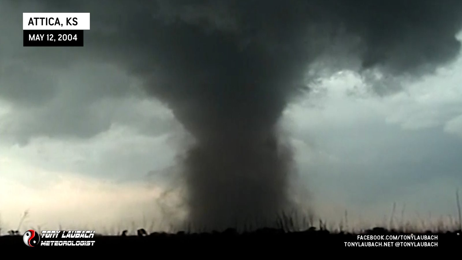
Chase Log: May 12, 2004
Southern Kansas (386 miles)
My first big tornado chase day! In total, I documented 7 tornadoes across southern KS, including the Attica F-2 and a nighttime F-4 with Warren Faidley. My breakout season was well underway.
• TORNADOES: 7
• MAX HAIL: 4.00"
• FLOODING: Observed
• Lightning Imagery: Not Captured
Full Write-Up
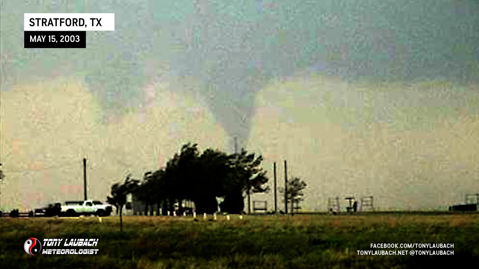
Chase Log: May 15, 2003
Texas Panhandle (968 miles)
I scored my first major tornado chase in the Panhandles between work shifts. Three tornadoes, including the Stratford wedge and it's satellite tornado along with an after-dark tornado near Guymon, Oklahoma.
• TORNADOES: 3
• MAX HAIL: None
• FLOODING: Observed
• Lightning Imagery: Not Captured
Full Write-Up