For the third time in a historical 2011 season, we were chasing a high risk with the potential to be yet another major tornado outbreak. While much more localized than the April 27 outbreak, this day still turned out to be quite deadly in the wake of the Joplin EF-5 that happened the day before.
We kicked off the day in Guthrie, Oklahoma where a short drive to our target allowed for a late morning. Everyone had a chance to sleep in a bit and gave us all a chance to pour over the morning data at breakfast in the hotel.

We gathered the gear and got the vehicles ready for the big day. Meanwhile, I had a chance to meet with my L.A. sister station’s meteorologists, Dallas Raines and Indra Peterson from KABC.

We ventured out east of town straight out OK-33 to Watonga where we stopped for lunch (for the second day in a row) and awaited storm initiation. While relaxing in Watonga over some Sonic, the PDS Tornado Watch went out for Oklahoma.


A cell going up to our southwest offered us the potential, so we ventured up US-281 northwest bound to intercept the storm along OK-51 just east of the US-182 junction.


The storm initially looked pretty meager as it moved to our immediate south, but did drop some 1-inch hail on us as we retreated east toward Canton. We stopped again at the OK-51/OK-58A junction and watched as a wall cloud and several funnels began to form very quickly.


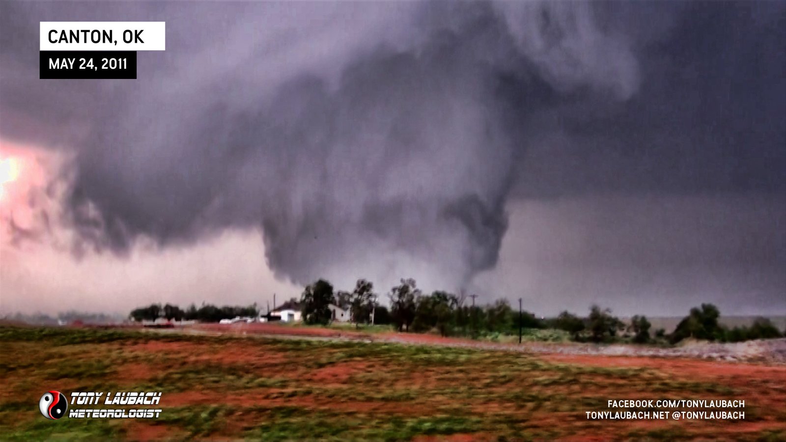
Several plumes of dust got kicked up beneath this feature which indicated the circulation had made it to the ground. With that said, we went into deployment mode. I immediately cut north on OK-58A and stopped about 3/4 mile north to observe the rapidly developing wall cloud.


Several vorticies danced beneath the feature until a full condensation funnel appeared. More vorticies danced beneath the funnel in a wild show to our west.


The tornado finally fully developed into a large cone to our immediate northwest and looked to be making a direct path to a nearby casino. Fortunately the tornado continued a mostly northerly job running nearly parallel to OK-58A toward Canton Lake.

The tornado continued to intensify and grow larger as it moved north toward the lake. We observed a large amount of debris being picked up and thrown by the tornado. Most of it appeared to be vegetation, but unfortunately took aim on a mobile home park in the area.


We continued north on OK-58A with hopes of getting on the dam road and continuing northeast. Unfortunately in our haste, we could not identify the turn we needed to take to pursue the storm across the dam. The option we saw was barricaded off and we assumed it to be the dam road, thus we did not proceed and watched as the tornado sped away across the lake to our northeast.


Once the tornado moved out of view, we circled back down to OK-51 and caught OK-58 along the east side of the lake. Other members of TWISTEX out ahead of us were noting the continuation of the Canton tornado as well as a second tornado that had touched down to the east of the highway. We never saw this second tornado enroute.
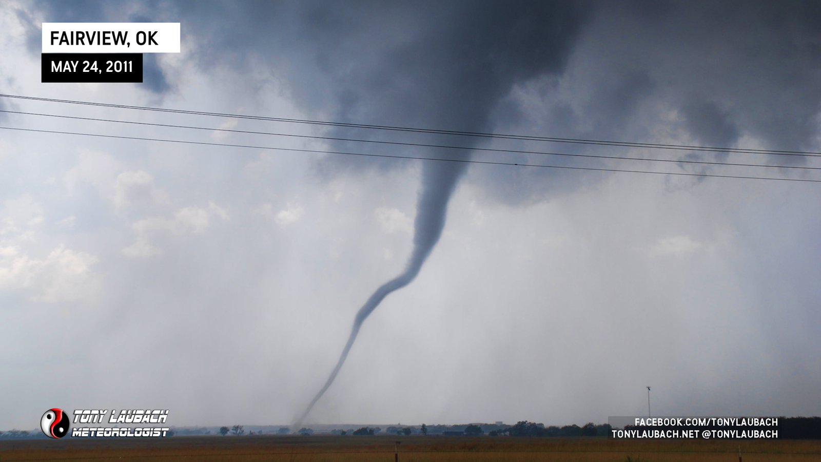
As we moved into the Fairview area from the south, another tornado began to form. This one would touch down and become my 200th career tornado.

With the tornado well off to the west, we took the opportunity to stop and enjoy this tornado for the beauty that it was. I took the opportunity to properly pose with my 200th career tornado.


Of course, given the historical significance of this tornado for me, my chase partner, Ed Grubb, captured an image of me standing in front of my 200th career tornado.


This storm pulled into a merger of several other storms to its north, thus we started making the sprint east and south in hopes of catching the numerous storms putting down strong tornadoes south and west of the OKC metro area. Unfortunately, we were unable to make it down in time to witness any other tornadoes for the day.
We ended up wrapping up the day south of Tulsa and opted to stay overnight in Glenpool. Certainly an amazing day that gave birth to the best tornado footage I have shot to date as well as knocking out tornado #200.