
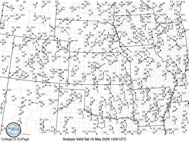
Target continues to shift further east today; a nice break given I start here in Kansas City. Morning surface analysis shows absolute trash dewpoints this morning across northeast Colorado, southwest Nebraska, and northwest Kansas. And you can see on the surface map above, there aren’t favorable wind directions to bring up those juicier numbers. You’ll likely see SOME rise out there, but not enough, even by high plains standards, to make a viable target out there. I have NO IDEA why SPC maintained their 5% tornado probs out there, but I would be shocked if they were not removed in the 1300z outlook.
I still stand by my idea last night that today is not a tornado day… I could see them adding a 5% somewhere in the northeast Kansas/southeast Nebraska and adjacent areas east. And that’s what I am targeting right now, somewhere in the Belleville/Seneca/Nebraska City/Geneva square. Also worth watching is south of Des Moines where hirez CAMS continue to pop a complex of storms. Again, probably a more messy solution in that area, but that seems to be hotspot #2. Again, nothing about today jumps off the page at me, and I still believe any tornado reports will be low in numbers and likely not too exciting, but I would almost (ALMOST) venture to say that we will see nothing tornadic west of US-183 today minus the off chance of some rando landspout, but assuming the dewpoints out that way can even get into the mid-40s, you’re still likely seeing a spread of 40-degrees out there, meaning said spouts would have to be to the level of my closing day tornado in 2021.
So I will await the 13z Day 1, and put $10 down on the western 5% being removed. I’d probably take a low bet on odds that they MAY add a 5% somewhere further east. Right now, given all I am seeing, my primary target is going to be northeast Kansas east of US-81, despite the CAMs insistence on much higher storm chances/coverage further east along I-35 in southern Iowa. I think if there is a place for a tornado, it’ll be if an isolated storm can interact with the wind shift there is deeper moisture. But all signs point to a pretty messy setup regardless. But we’re here to play, so play I will…
That said, a shower and a milking of the checkout here in KC seem appropriate this morning. It’s an easy 3-4 hour haul back toward Belleville, so assuming an 11am departure and enough fuel to get to Belleville, I should be able to do it easily in one sitting. That said, being up at 5am was a useless endeavor, so another hour of sleep may sneak its way in before I load up and head out.