
Tomorrow is likely NOT a tornado day… I will just get that out of the way right now… yes, there probably will be a couple that sneak their way into the reports, but overall, I think tomorrow is likely gonna be a damaging wind and hail day. Today, I wussed out; nothing about today was highly anticipated, and most of the better parameters shifted well north and east, and anything I was going to get on early evening was taking me the opposite direction I needed to go, so I threw a couple chips on some convection that tried to fire west of Kansas City, but nothing took hold. No loss on that.
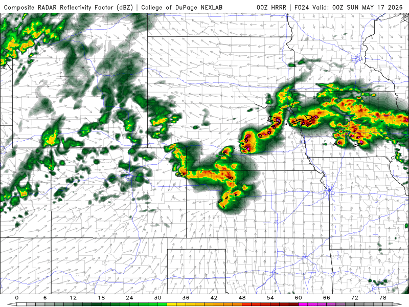
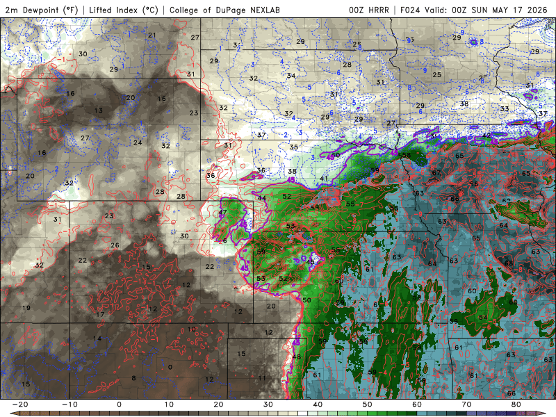
Biggest issue tomorrow seems pretty easy to spot, marginal moisture at the surface. Even the Colorado play is going to struggle to get to what I would consider a minimum dewpoint. If I were coming from the west (home), I would probably give it a bit more attention, but I am coming in from the east, and thus my eyes are drawn to the I-80 Central Nebraska target. Models have been consistent with that area, showing some hefty supercells developing, likely high based with big hail given the spreads of 30+ degrees. Colorado will see similar spreads, maybe slightly more given dewpoints progged in the upper 40s out there. But currently, I do not see enough in the Colorado target to warrant the rolling across the entire state of Kansas or Nebraska for. Also worth a mention, a potential play in southeast Nebraska, north of Kansas City. Not giving that too much at the moment, but it DOES exist. But that said, I am going to aim for Grand Island by 3pm.
Sunday continues to be eastern Nebraska north of I-80 (the NAMNEST takes a HUGE dump all over Sunday, FYI: probably why it is being retired later this year – haha). No significant changes in my thoughts on that right now. I have coordinated with Ed to have him meet me in GI as we’ll saddle up together for the Sunday/Monday plays (maybe Tuesday if warranted). Monday has a couple potential plays; still earmarked as the biggest of the two headliner days, but has TWO potential targets. The first and most obvious would be the Iowa play, likely seeing a lot of storms up that way. The lesser, secondary target, but equally as volatile, could be southern Kansas/northern Oklahoma. While not as quick to get to Monday, it can easily be done if that one looks to be a solid get. Assuming we get a couple storms in that environment, they’ll likely be less overall verses up north, which one of the Iowa failure modes would be too many storms. Too early to tell, too early to worry, but know it’s a thing I will float back to as I look ahead to Monday. Tuesday is nothing more than a mop-up day, which if we stay north on Monday, may have higher odds we play the northern target in Illinois. Anything south would be in play, but to a lesser extent. It would NOT surprise me to see Sunday end up being the bigger day from a chaser perspective, but too much on the plate Monday to say that with any confidence.
So yeah, some late evening thoughts on the days ahead as I watch another abysmal Rockies baseball game. They’re losing to Arizona 9 to 1 in the top of the 9th, and were down 6 to 0 before they ever even came up to bat in the first. Fortunately this will end soon, and I will turn myself in to a pumpkin, get up reasonably early, and hike myself up I-29 into Nebraska, then cut over to Grand Island to set up for tomorrow’s hail chase day.
BTW, snow potential along the lower Front Range locations has all but vanished… not terribly concerned with this particular event for the Front Range. Mountains oughta do pretty good, and still looks like a good heavy-moisture system for northern Colorado, so adding some tornado juice to the region regardless. Now I just do not have to worry about covering the gardens.
See ya on the road tomorrow! We go for real then!