
An answer, that as one of my current favorite songs by Harem Scarem is titled, is ‘Slowly Slipping Away’. Truthfully, what a great album they did there in the early 90s at the tail end of the hair band era (damn you, grunge)… anywoo, I digress…
It was about 36 hours ago when today looked like a sure-fire chase day, but similar to just about every day this past week, things just unraveled, this day a bit slower than the earlier days this week. Honestly, if I had it to do over again, I would’ve chased yesterday and sat out today as yesterday fell into the over-performing mode compared to the models, which have had an ass time resolving the convective potential of every day this past week. Last night, there were glimmers of intent to fire storms late afternoon, perhaps after 4pm, across the Black Hills and slide them southeast into northern Nebraska, but suddenly overnight convection popped into chat and that has thrown a huge wrench into things for today. Now, as the last few morning runs have indicated, nothing is certain with the morning showers and storms which are currently ongoing from North Platte northward and even new development near Julesburg, all of which does nothing but prolong the recovery time, and thus delay storm initiation further and further into the day, and possibly into the night.
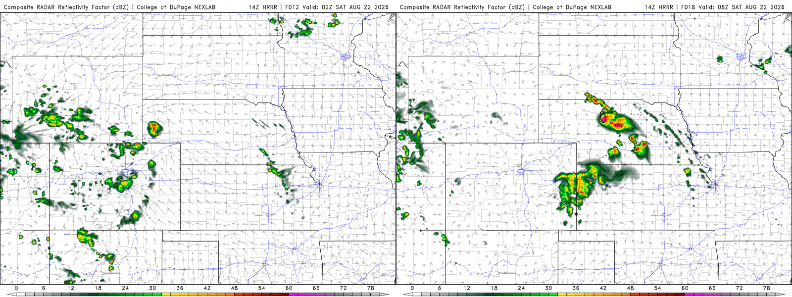
Shown above are the latest HRRR models runs for 8PM and 2AM MDT (9PM/3AM CDT) when models start to initiate the two rounds of storms. The first, which if you eliminate the time, is great due to its location there just north of I-80 in the southern Nebraska Panhandle, meaning it’s less than a 3 hour shot to get up there. The bad news, it’s 8pm. Optimistically, storms COULD fire at or just before sunset, leaving a short daylight window available before darkness sets in. Now, if you’re hunting lightning, which I will not rule out as being Main Mission #1, that may not be a bad thing, and could offer some decent lightning photography opportunities, which if I am being honest is the sole reason I am even keeping this scenario in mind. Right now, there is little to NO indication of initiation closer to say 6pm, which does put a big hurt on potential to head up that way. But the lightning scenario, and perhaps some quicker than expected recovery could still yield a reason to make the run up there come about 3pm, which right now, is slated as my cut-off.
The second round of storms, which likely does not come into play, would be the overnight round, likely the stronger of the two rounds, developing after midnight and sliding southeast toward I-80. Given the after-midnight timing, it’s highly unlikely that factors into my plans, other than the chance such a system is far enough west to impact, say North Platte, where I would probably hunker down for the night. Even in that scenario, history teaches me that I would unlikely put forth any major effort to do anything with those storms, meaning they’d have to actually awaken me from slumber to where I would go out in my pajamas and shoot from the hotel cover out front. Not something I would put any money on me doing.
So right now as of this writing, it’s just after 10am; waiting for the 1630z SPC outlook to probably tell me nothing, but as of now, I sit at a GENEROUS 50% chance to go. Every hour the CAMs continue to lack initiation before 8pm is another 10% drop; by 3pm, that chance will sit at zero. I will need a solid sign of convection ongoing BEFORE 7pm to keep my hopes alive… right now, that’s not happening. 21z runs will be the final ones to convince me.